The Kings Canyon
The Kings Canyon is the largest canyon in the Red Centre and is part of the 72,000-acre Watarrka National Park in the George range. It is located 323 km southwest of Alice Springs and 1316 km south of Darwin. The Kings Canyon is the most western part of the George Gill Range.
Description
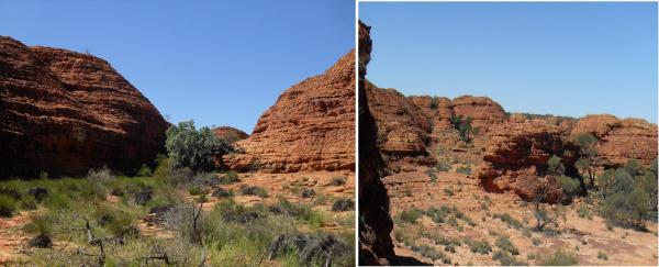
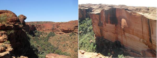
The walls of Kings Canyon are made of red, yellow and white sandstone. The walls of the canyon are a little over 200 m high. The sandstone is red and yellow in color from iron oxides (hematite and limonite) this results in a very ruggedly and intricately formed interesting structures from different colors and drawings. Erosion by wind and sun leaves with rounded sand molds.
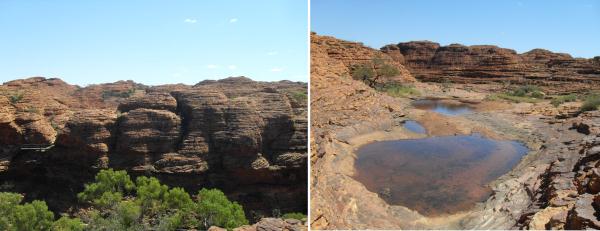
There are two routes leading through the canyon. An approximately 2.6 km long path (Kings Creek Walk) spans Kings Cross on the bottom of the gorge and takes about 1 hour. The end of the path leads to an area with a view of the steep slippery cliffs. There is also a route to the canyon around (Kings Canyon Rim Walk), which crosses over the plateau, about 6 km long and takes on average three to four hours round-time. This begins with a rather steep section, which locals call Heartbreak Hill. Once at the top, a stunning view over the gorge ensues, showing the beehive rock formations of the plateau and over the wide landscape of the entire area. At the foot of the canyon, a little pond is running through it which is called Kings Creek. After about half of the distance of the path, a track descends into a water hole, which is also known as the Garden of Eden, it is always moist and therefore it has a lively fauna and flora. In the Canyon, certain rare sub-tropical plants in Australia, such as the cycads, are maintained in protected shelters.
After a slow descent from the plateau, you can get back to the starting point which is the car park.
GEOLOGY
200million years ago the land masses on the Earth were a single contiguous continent, which is called Pangaea. This "supercontinent" broke apart in the course of time. This resulted in Laurasia and Gondwana. About 100 million years ago tremendous forces led to Gondwana breaking up into individual plates of the earth`s crust. Initially India and Africa separated from Gondwana, leaving South America, Australia and Antarctica together. Eventually they separated too, with Australia a separate plate and continently by about 60 million years ago. The Australian plate is moving northwards and is subducting under the Asian and Pacific plate.
The current 'face' of Australia has been forming since the Mesozoic over 100 million years ago and many of the landscapes we see today are very ancient. During the last glaciation there were small glaciers on the high points of the southern great divide and Tasmania and sea level was low.
Mountain building and flooding, volcanism and glaciations and erosion by wind and water have shaped Australia's present form but over many millions of years.
The geology of the gorge is in the Northern Territory unique. Cracks led to fractures within the sandstone layers of the George Gill Range, and large boulders were left on the surface, which plunged in part down into the newly formed gorges. The square-shaped rocks weathered, finally becoming beehive domes, which now bear the name, `Lost City`.The fracture of rock at the bottom of the gorge is in times of drought, a water reservoir. The geological elevation processes left behind a valley with vertical sandstone walls. In periods of rain, the porous sandstone saves the water like a sponge, so it oozes slowly down to the bottom of the gorge, found in the moist crevices many plants and animals shelter.
Log-requirements:
Begin your hike at
S 24° 15.339 E 131° 34. 227
Here inform yourself on the information board and take the long walk on the plateau (Kings Canyon Rim Walk),
Along the way, you will find some information tables which will help you to answer to the following questions.
1. until when was Australia a windswept plain covered with sand dunes?
2. what caused the crack in the Mereenie sandstones to widen and deepen?
3. please briefly describe how the domes of the lost city were formed?
4. take a nice photo at the photo point S 24° E 131° 15 352 34 242 and write it down in a log book.
The correct answers will then count as log requests!
Please to not forget upload a nice photo of yourself or a personal object in the background of the beautiful location.
Have fun on this geological voyage of discovery and good luck!
Team sissifalke