[ESP]:
El río Ter nace en Ulldeter a 2.480 metros de altitud al pie de un
circo glaciar en la comarca pirenaica del Ripollès, Cataluña
(España), muy cerca de la población de Setcases y, después de una
longitud de poco más de 200 km, desemboca en el Mar Mediterráneo
aguas abajo de Torroella de Montgrí, entre l’Estartit y Pals
en el paraje conocido como la Gola del Ter, frente a las Illes
Medes.
Este multicaché
pretende haceros descubrir este bonito y tranquilo paraje que
formará parte del futuro Parc Natural del Montgrí, Illes Medes i
Baix Ter. Se recomienda hacerlo en bicicleta pues no hay desnivel
alguno y las distancias son cortas.
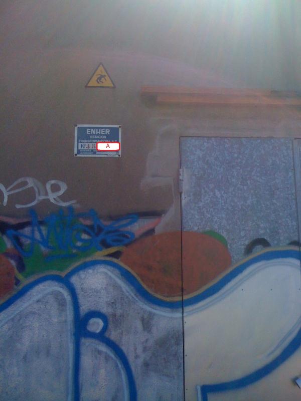
Punto
1:
En la caseta de luz
hay una placa con 5 dígitos rojos. A es igual a los 3 últimos
números de esta placa.
Punto
2:
En este punto hay
un cartel indicativo de las distancias a 3 destinaciones. B es la
suma de las tres longitudes en Km. (conservar
decimales).
Punto
3:
En este otro cartel
indicativo se precisa:
C es el tiempo en horas hasta l’Estartit
D es el tiempo en minutos hasta la Gola
Punto
4:
En este panel
encontraréis la información para resolver la siguiente pregunta. E
corresponde a los Km. que tiene la ruta senderista del
Ter.
Zona
Cache:
El cache se
encuentra en las coordenadas:
N 42º 01.XXX
E 003º 11.YYY
donde:
XXX=
A-5B+C+D
YYY=
2E+3D-C
[ENG]:
The river Ter born in Ulldeter at 2480 meters of altitude to the
foot of a glacial cirque in the Pyrenees region of Ripollès,
Catalonia (Spain), near the town of Setcases and, after a length of
just over 200 km, flows in the Mediterranean Sea between L'Estartit
and Pals in the area known as the Gola del Ter, in front of Medes
Islands.
This multicaché intends to discover this beautiful and quite place
that will be part of the future Parc Natural del Montgrí, Illes
Medes i Baix Ter. Cycling conditions are recommended as there is no
slope and distances are short.
Point 1:
At the house there is a plate with 5 red digits. A is equal to the
last 3 digits. See Photo.
Point 2:
At this point there is a signpost indicating the distances to three
destinations. B is the sum of the three lengths in kilometers
(keeping decimal).
Point 3:
In another indicating sign this is needed:
C is the time in hours to l'Estartit
D is the time in minutes to Gola
Point 4:
In this panel you will find information to slove the next question.
E is the distants en km of walking route of Ter river.
Final Cache:
The cache is located at coordinates:
N 42º 01.XXX
E 003º 11.YYY
where:
XXX=
A-5B+C+D
YYY=
2E+3D-C