Ancient Lake Bottom (The Great Swamp) EarthCache
Ancient Lake Bottom (The Great Swamp)
Related Web Page
Please note Use of geocaching.com services is subject to the terms and conditions
in our disclaimer.
The purpose of this earthcache is to bring you to a geologically
significant place, that due to the work of volunteers and
conservationists has been restored to a more natural, ecologically
beneficial state.
You will walk a trail which is actually the bottom of an ancient
lake. Along the way you may get lucky and observe a Yellow Warbler,
a Painted Turtle, or perhaps a Water Snake.
The Great Swamp National Wildlife Refuge (NWR) is one of more than
550 refuges in the National Wildlife Refuge System that is
administered by the Department of the Interior's U.S. Fish and
Wildlife Service.
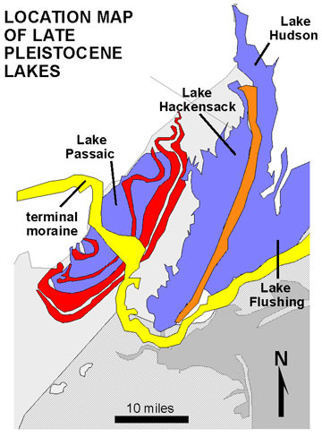
Origin of the Great Swamp
Roughly 25,000 years ago, where the Wisconsin Glacier reached its
furthest point south and stopped.The Great Swamp is the remnant of
a lake bottom of a once-mighty glacial lake called Glacial Lake
Passaic that about 15,000 to 11,000 years ago extended for 30 miles
(48 km) in length and was 10 miles (16 km) wide, in what is
presently northern New Jersey. The lake was formed by the melting
waters of the retreating Wisconsin Glacier at the end of the last
Ice Age. The glacier had pushed a moraine ahead of its advance, a
rubble of soil and rocks that plugged the existing outlet for the
waters that drained into the area normally.
As the retreating glacier melted, the waters rose to create the lake before a new
outlet began to allow the water to exit at a much higher elevation,
hence, the lake became established. The course of the Passaic River
that had drained the swamp prior to the formation of the glacial
lake, became altered due to the plug of its outlet and the water
released as the glacier melted filled the basin before it was able
to seek a new path to vent into the sea.
A range of mountains to
the west of Morristown formed the western boundary of the new lake
and the most easterly line of the Watchung Mountains became the
eastern boundary. The tops of some of the Watchung range became
islands in the great lake. Water that had vented through, or to the
south of the Watchung range found a new path that altered, forever,
the old drainage paths and, when the plug collapsed the river still
was forced to travel north through the length of the range before
finding a new outlet near present day Paterson where it could
manage the eastern turn toward the sea.
Eventually, the retreating glacier uncovered a second outlet at
what is now Little Falls Gap, and the lake waters drained out along
the Passaic River. The lake disappeared and was eventually replaced
by extensive marshes and swamps which would be named Black Meadows,
Great Piece Meadows, Lee Meadows, Troy Meadows, Long Meadow, Bog
and Vly Meadows, Hatfield Swamp, and Great Swamp.
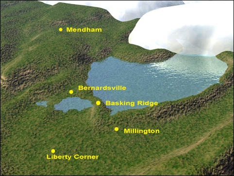
For thousands of years the region was inundated by a lake whose
size and depth fluctuated with time. Fine particles of sediment
carried by the water settled to the bottom of the lake, forming a
thick layer of clay.
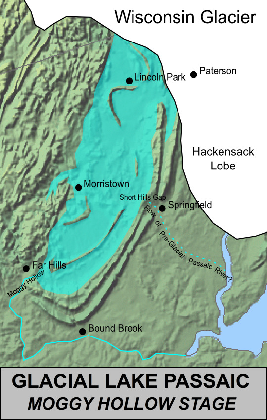
The “Wisconsin Stage” of the glacial epoch, which
lasted 56,000 years, is largely responsible for much of our current
topography. The Wisconsin glacier reached its southernmost advance
in nearby Chatham Township. The forward edge of the advancing
glacier brought enormous amounts of rocky rubble and finer
material, which the melting ice then deposited as a long, low ridge
of debris called a “moraine.” Present day Route 124 now
runs through Chatham Borough, Madison, and into Morris Township
along, or close to, the top of this terminal moraine. The
moraine’s surface appearance is now that of a wide, gently
rolling, wooded hill or ridge with occasional deep potholes, often
filled with water, where glacial ice blocks melted while material
was being deposited around them. Kelly’s Pond, in the eastern
part of the Chatham, is an example of such a pond.
In 1966, the refuge was designated a Registered National Natural
landmark and in 1968 nearly 4,000 acres were designated by Congress
as the Department of the Interior's first Wilderness Area. (Taken
from Great Swamp brochure and other sources)
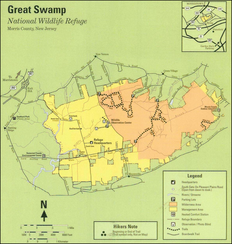
Wildlife Observation Center
I was surprised that this had not already been created as an
EarthCache. My family and I have been enjoying walking through the
pristine area for years. This is also a great place to take scouts
for an easy and informative hike.
I created this earthcache as a 1-1 as I encourage all cachers to
visit the beautiful boardwalk trails here. There is no leaving the
boardwalk and traditional caches are not allowed in the
refuge.
Park at the listed coordinates and I suggest entering the boardwalk
on the right, just behind the information display..
Wheelchair and stroller access is easy as the boardwalks are wide
and mostly flat with very little elevation change. There are many,
many more acres to enjoy in the refuge, but this area is the most
accessible. Geologically speaking, there is not necessarily much to
see in an ancient lake bottom. Its bedrock is covered by a deep
layer of sedimentary soil that has flowed in and out for thousands
of years. However, it contains an excellent sedimentary record for
deciphering previous geologic eras.
Pick up some information at the Welcome Center (open seasonally)
off the parking area. I always like to stop and remain silent for a
few moments and see how many creatures I can identify.
The refuge is open sunrise to sunset. Please bring insect
repellent. In warmer months you will surely need it.
Consider that you are walking in the bottom of an ancient lake. The
mountains off to the east and to the west were islands in this
lake. Can you envision the landscape of NJ as it existed at such time?
To log this cache, I suggest you do the following tasks:
1. If the mountains off to the east and west formed the edges of
this lake, estimate how deep underwater this area was 15000 years
ago. Take a photo of your GPSr at the lowest point of elevation
along your walk and send it to me. Do not post it.
2. On your way in, you may have driven through or close to a town
of which the land was created by the great pile of earth and rocks
pushed forward by the glacier. Once the glacier stopped, a "ridge"
was formed. What nearby town is situated on this "ridge"? (the map
may provide clues)
3. Much of the underlying shale and sandstone was eroded over time
by the lake. Deposits of thick clay make up the Swamp's bottom. The
lake's mountainous boundaries are made up of an igneous rock that
withstood such erosion, as is some of the underlying rock, hence
creating this basin. What is the name of this mineral common to the
area? Search the area while on your trek. Can you find any samples?
If not, why do you think this is? If so, please publicly post the
coords and description.
4. There is a tree just at the exit of the boardwalk, which is
marked with a number. What species of tree is this? You can pick up
a tree guide at the information building at the parking lot.
Please do not disturb any plants or animals. This is their place
and we are only visitors. This earthcache will give you a unique
experience in a nature trek as the surrounding swamp areas remain
completely natural. The boardwalk is the only addition, allowing
you into areas unreachable otherwise without causing damage to the
habitats.
Additional Hints
(Decrypt)
Nf gur fpbhgf fnl: Yrnir ab genpr. Gur Ershtr Znantrzrag vf vagrerfgrq va lbhe pbzzragf naq srrqonpx, abg yvggre be nalguvat gung jbhyq qvfgheo gur nern. Gunaxf!
Treasures
You'll collect a digital Treasure from one of these collections when you find and log this geocache:

Loading Treasures