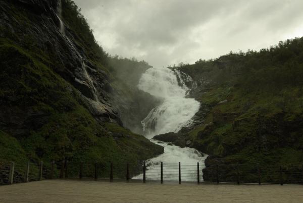
Kjosfossen Waterfall
Norwegian:
Kjosfossen er en foss i Flåmselva i Aurland kommune i Sogn og
Fjordane. Fossen, som er en av Norges mest besøkte
turistattraksjoner, ligger like nedenfor Reinungavatnet, øverst i
Flåmsdalen. Den har en total fallhøyde på 225 meter, fordelt
på flere fall med en horisontal lengde på rundt 669 meter.
Flåmsbana
passerer direkte foran og over den nedre delen av fossen, som er en
av hovedattraksjonene for turistene som tar Flåmsbana. Her ligger Kjosfossen holdeplass, som ble
åpnet i 1951 for at de reisende med banen kunne forlate toget for å
besiktige vannfallet. Fossen og holdeplassen ligger rundt fire
kilometer fra Myrdal stasjon. Under
hovedturistsesongen om sommeren viser huldra seg når toget kommer inn på
holdeplassen, og oppfører en dans og sang ved fossen. Skuespillerne
er studenter ved den norske ballettskole.
Det er bygget et mindre kraftverk i fossen, Kjosfoss
kraftverk, for å gi strøm til baneanlegget.
English:
General
information:
A waterfall is a place where
flowing water rapidly drops in elevation as it flows over a steep
region or a cliff. Waterfalls are considered to be one of the most
beautiful phenomena in nature.
Kjosfossen waterfall
lies in 669 meters above see level and is located between Flam and
Myrdal just next to the railroad. This waterfall supplies
the hydroelectric power for the railroad. You can do several
trekking activities in this very nice area
A waterfall is a place where flowing water rapidly drops
in elevation as it flows over a steep region or a cliff. Waterfalls
are considered to be one of the most beautiful phenomena in
nature.

Formation
Waterfalls are most commonly formed
when a river is young.[1]
At these times the channel is often narrow and deep. When the river
courses over resistant bedrock, erosion happens slowly, while
downstream the erosion occurs more rapidly.[1][2]
As the watercourse increases its velocity at the edge of the
waterfall, it plucks material from the riverbed. Whirlpools created in
the turbulence as well as sand and stones carried by the
watercourse increase the erosion capacity.[1]
This causes the waterfall to carve deeper into the bed and to
recede upstream. Often over time, the waterfall will recede back to
form a canyon or gorge downstream as it recedes upstream, and it
will carve deeper into the ridge above it.[3]
The rate of retreat for a waterfall can be as high as one and half
metres per year.[1]
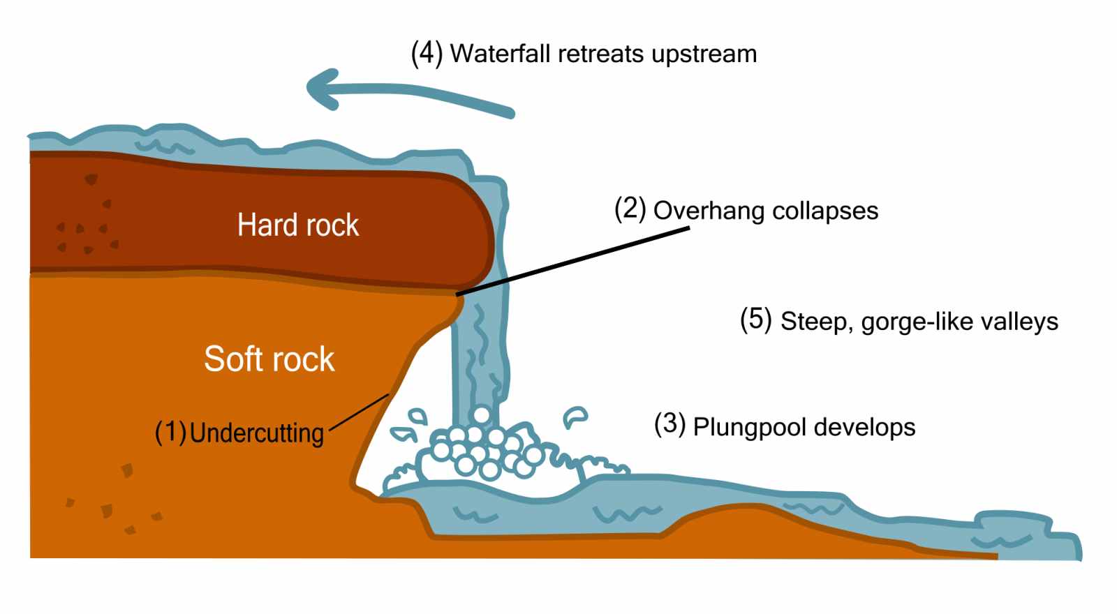
Often, the rock stratum just below the more
resistant shelf will be of a softer type, meaning that undercutting
due to splashback will occur here to form a shallow cave-like
formation known as a rock shelter or plunge pool under
and behind the waterfall. Eventually, the outcropping, more resistant cap rock
will collapse under pressure to add blocks of rock to the base of
the waterfall. These blocks of rock are then broken down into
smaller boulders by attrition as they
collide with each other, and they also erode the base of the
waterfall by abrasion, creating a deep
plunge pool or gorge.
Streams become wider and shallower
just above waterfalls due to flowing over the rock shelf, and there
is usually a deep pool just below the waterfall because of the
kinetic energy of the water
hitting the bottom. Waterfalls normally form in a rocky area due to
erosion. After a long period of being fully formed, the water
falling off the ledge will retreat, causing a horizontal pit
parallel to the waterfall wall. Eventually, as the pit grows
deeper, the waterfall collapses to be replaced by a steeply sloping
stretch of river bed.[1]
A river sometimes flows over a large
step in the rocks that may have been formed by a fault
line. Waterfalls can occur along the edge of a glacial trough, whereby a stream
or river flowing into a glacier continues to flow into a valley
after the glacier has receded or melted. The large waterfalls in
Yosemite Valley are examples of
this phenomenon, which is referred to as a hanging
valley. Another reason hanging valleys may form is where two
rivers join and one is flowing faster than the other.[1]

Classification
Waterfalls are grouped into ten
broad classes based on the average volume of water present on the
fall (which depends on both the waterfall's average flow and its
height) using a logarithmic scale. Class 10
waterfalls include Niagara Falls, Paulo
Afonso Falls and Khone Falls.
Classes of other well-known
waterfalls include Victoria Falls and Kaieteur
Falls (Class 9); Rhine Falls and Gullfoss (Class 8); Angel Falls and
Dettifoss
(Class 7); Yosemite Falls, Lower
Yellowstone Falls and Umphang Thee Lor
Sue Waterfall (Class 6); Sutherland Falls (Class
5).[4]
Types
- Block: Water descends from a relatively wide stream or
river.[5][2]
- Cascade: Water descends a series of rock
steps.[5][2]
- Cataract: A large, powerful waterfall.[5]
- Chute: A large quantity of water forced through a
narrow, vertical passage.[5]
- Fan: Water spreads horizontally as it descends while
remaining in contact with bedrock.[5]
- Frozen: Any waterfall which has some element of
ice.[5]
- Horsetail: Descending water maintains some contact with
bedrock.[5]
- Plunge: Water descends vertically, losing contact with
the bedrock surface.[5]
- Punchbowl: Water descends in a constricted form and then
spreads out in a wider pool.[5]
- Segmented: Distinctly separate flows of water form as it
descends.[5]
- Tiered: Water drops in a series of distinct steps or
falls.[5]
- Multi-step: A series of waterfalls one after another of
roughly the same size each with its own sunken plunge
pool.[5]
Source: free encyclopedia and
other educational materials
Given coordinates will lead you on the platform
near Kjosfossen Waterfall. The best way how to reach this spot is
by the train. The train goes from Flam to Myrdal approximately
every hour.
To log this Earthcache, please:
1. take a picture of youself and your's GPS on the
Flamsbana platform showing the waterfall in the background. IT
IS OPTIONAL
2. send me via email (Aucoin.J@seznam.cz) how are
waterfalls formed.
3. on the left side of the train platform when you are looking at
the waterfall is info table (on the rock). What is written on
this info table ?