<
/>
The coordinates will lead you to the Mississippi River valley
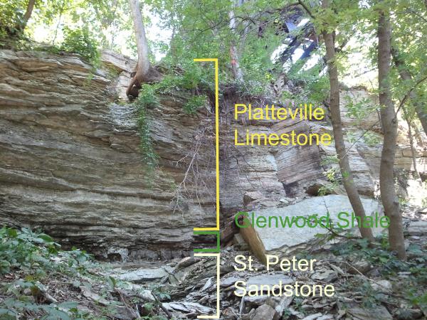
wall with a fine example of exposed Platteville Limestone. The
bluff face along the river is comprised of three main layers.
Underneath the top soil and glacial drift, the three layers from
top to bottom are the Platteville Limestone, Glenwood Shale, and
St. Peter sandstone. The Platteville is buff in color and is
erosionally resistant, which often causes it to overhang above the
easily erodible Glenwood and St. Peter below it. The Platteville,
like the Glenwood and St. Peter, is widespread across the Midwest
and is approximately 30 feet thick in Minnesota. This carbonate
formation is mostly made up of limestone with some dolomite in its
lowest member and some shale beddings in its upper parts (1). The
Platteville formed during the Middle Ordovician era in a shallow
marine carbonate bank environment (2). Whereas the St. Peter was
formed in a windy, shallow marine environment, the Platteville
formed when the inland sea that once covered the land was deeper,
in a marine shelf environment (3). At the time, the Twin Cities
area was a marine basin known as the Hollandale Embayment. To the
northwest laid the shores of the northeast-trending
Transcontinental Arch and to the Northeast laid the shores of the
northwest-trending Wisconsin Arch (2).
The limestone consists of mineral calcite, which formed from
solidified calcareous ooze that existed at the bottom of the marine
basin (4). Geologists now this because of the fossils in the
limestone. Sea life was abundant during the Middle Ordovician, and
several species of brachiopods, cephalopods, gastropods, bryozoa,
crinoids, and trilobites sank into the layers of calcareous ooze to
form fossils (1).

Four foot long Cephalopod found in the Platteville (1).
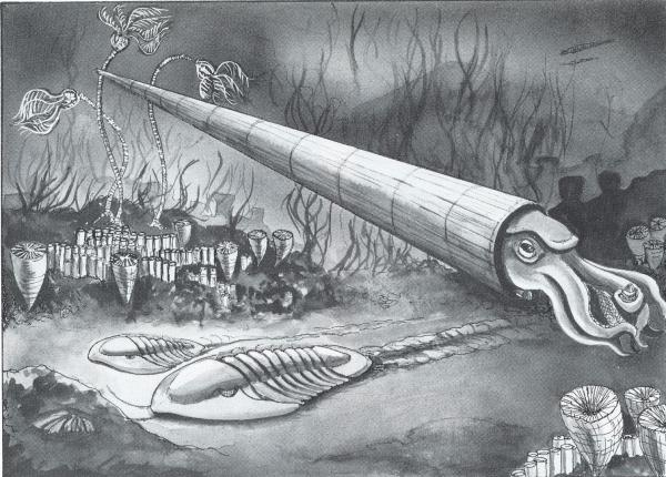 Terror of the Ordivician sea (1).
Some large cephalopods can be found in the Platteville,
including some that are as large as 4.5 meters long and 25 cm in
diameter (1). Geologists have found cephalopods 10 “ in
diameter sunk into the ooze to the depth of two-thirds of their
shell diameters. They found the exposed parts of the cephalopods
planed off at the top of the ooze layer. This meant that exposed
parts had dissolved in the carbonate sea before the deposition of
next layer of ooze bedding and that long intervals must have
occurred between beddings as layer after layer of ooze piled up
(2). When you look at the limestone, you will see horizontal lines.
These lines represent the bedding planes (or layers of calcareous
ooze), which vary in thickness. Thin bedding planes indicate
periods of less deposition and thicker planes indicate periods of
rapid deposition. Cracks in the limestone that are parallel with
the ground are called cleavage, and run along the bedding planes.
Cracks that run perpendicular to the ground are called fracture
(4).
To claim credit for this EarthCache, email us the answers to the
following:
1. Estimate the height of the exposed limestone to determine the
approximate Platteville accumulation at this location. Take an
elevation measurement at the bottom of the limestone formation, and
subtract that from another elevation reading at the rim of the
valley, by the East River Parkway.
2. Examine the limestone. Which visible cracks are the longest?
Those that run parallel to the ground or those that are
perpendicular to the ground? What are these cracks called?
3. Look around you. What evidence do you see that would support
the theory that the Platteville Formation was formed in a shallow
marine bank environment?
Sources used:
1. Ojakangas, R. W., & Matsch, C. L. (1982).
Minnesota’s geology. Minneapolis: University of Minnesota
Press.
2. Webers, Gerald F. (1972). Paleoecology of the Cambrian and
Ordovician strata of Minnesota. In Sims, P. K., & Morey, G. B.
(Eds.), Geology of Minnesota: A centennial volume. St. Paul, MN:
Minnesota Geological Survey. 474-484.
3. Mossler, J. H. (1985). Sedimentology of the Middle Ordovician
Platteville Formation Southeastern Minnesota. In Sloan, R. E.
(Eds.), Report of investigations (Minnesota Geological Survey). St.
Paul, MN: University of Minnesota. 33.
4. GEO 1001/1101: Earth and Its Environments (2010). River
bluffs outcrop. Accessed June 30, 2010 from
http://www.geo.umn.edu/courses/1001/campus/pages/river/river.htm.