
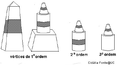
A Rede Geodésica Nacional (RGN) é composta por um conjunto de pontos coordenados - Vértices Geodésicos - que possibilitam a referenciação espacial.
O número de vértices existentes na totalidade do território (Portugal Continental e Regiões Autónomas) é, actualmente, de cerca de nove mil, repartidos por vértices de:
Continente: 1ª Ordem (cerca de 120),
2ª Ordem (cerca de 900)
e 3ª Ordem (com uma densidade aproximada de 1 vértice por cada 10 km²)
Arquipélago dos Açores: cerca de 500
Arquipélago da Madeira: cerca de 150.
A RGN é a infra-estrutura básica onde se apoia toda a cartografia do País, e que serve todos aqueles (empresas, autarquias e outros organismos públicos e privados) que, por força das suas actividades, necessitam de referenciar geograficamente os seus projectos (os Planos Directores Municipais, por exemplo).
Textos retirados de :
http://www.igeo.pt/IGEO/portugues/Frameset-produtos.html
Esta é uma cache mais díficil de alcançar do que a maioria das que estão em VG´s!
Existem dois pontos de partida para a mesma, um pelo Aruil com pouco mais de dois km, mais plano e outro por Á-dos-Cãos com cerca de 2.5km, bem mais inclinado (caminho mais bonito). Este ultimo pode ser a partir da cache -
santos da serra não fazem milagres [Loures]
Eu costumo fazer este caminho de Btt, como podem comprovar aqui - http://ridewithgps.com/trips/99512 - mas pode ser feito a pé, o carro terá de ficar num ponto de entrada ou pouco mais perto da cache pois o caminho não é nada aconselhado, sendo que, por Á-dos-Cãos não dá mesmo.
Boa caminhada!!! :) e aproveitem a vista!
Atenção á época e aos dias de caça sff. Há muitos dias para se fazerem caches!
Deixem tudo como encontrarem, cancelas fechadas, etc.
ENGLISH:
The National Geodetic Network (RGN) is composed by a set of coordinate points - Geodesic Vertex - which allow for spatial referencing.
The number of vertices exist in the whole country (Portugal mainland and islands) is now about nine thousand, broken down by vertices:
Continent: 1st Order (about 120), 2nd order (about 900) and 3rd Order (with an approximate density of 1 node per 10 square km) Azores, about 500 Madeira Islands: About 150
The RGN is the basic infrastructure which supports all mapping of the country, and serving all those (businesses, municipalities and other public and private) which, by virtue of their activities, need to reference geographically their projects (the Municipal Master Plans, for example).
Texts taken from:
http://www.igeo.pt/IGEO/portugues/Frameset-produtos.html
This cache is a more difficult to achieve than most that are in VG's!
There are two starting points for the same, by Aruil with a little over two miles, flat and one from Á-dos-Cãos with about 2.5km, and more inclined (way more beautiful). The start may be from the cache - http://www.geocaching.com/seek/cache_details.aspx?guid=6e240d14-5c0a-43db-bc3d-68a23b963644
I usually make this journey by MTB, you can check it here - http://ridewithgps.com/trips/99512 - but it can be done on foot, the car will have to stay in one point of entry or a little closer to the cache because the path is nothing desirable, and the one from Á-dos-Cãos cant be done by car.
Good walking! :) And enjoy the view!
Attention to the hunting season and hunting days please. There are many days to find caches!
Leave everything as you find it, gates closed, etc..