Geologic Highlights: Remnant of a rock blade left behind
as a recessional cataract carved out the Upper Grand Coulee.
Geologic contact between basalt lava and older granitic basement
rock. Huge glacial erratics and till from former ice sheet that
once buried the summit of Steamboat Rock under a massive
glacier.
Cache Elevation: 2,300 ft
Directions to trailhead: From Steamboat Rock State Park
follow one of the trails that heads west toward the base of the
monolith. The trail to summit requires some scrambling up a steep,
scree-covered slope. Once on top a relatively level, primitive
trail follows the perimeter of Steamboat Rock. From the trailhead
the total distance to the Earthcache is ~1.6 mi. (one way),
vertical climb = 720 ft

Figure 1. Sunrise over the Steamboat Rock
monolith.
Steamboat Rock is an erosional remnant of a rock
blade, created as a dual, recessional cataract passed by on its
northward march up Grand Coulee. In between two amphitheater-like
cataracts a narrow rib of basalt is often preserved. The cataracts
responsible for Steamboat Rock long ago disappeared, having been
consumed by one of the last Ice Age floods that breached the head
of coulee about 15,000 years ago. This event occurred where Grand
Coulee joins the Columbia Valley about 7 miles to the northeast
(Figure 2).

Figure 2. Maximum extent of the
Okanogan Ice Lobe in the vicinity of Steamboat Rock and Grand
Coulee about 20,000 years ago. West of Grand Coulee the furthest
extent of the ice is well defined by the Withrow Moraine. East of
the Grand Coulee the evidence for maximum ice advance was destroyed
by later Ice Age floods and inferred with the dashed white line.
During maximum ice advance some floodwaters may have squeezed
through Grand Coulee (blue arrow) along the leading edge of the ice
sheet. Younger floods carved Grand Coulee when the glacier
didn’t advance across the entire width of the
coulee.
The flat-topped summit of
Steamboat Rock lies at about the same elevation as the cliffs on
either side of the coulee (Figure 3), indicating the basalt lava
rock was once a continuous plateau prior to erosion of Grand Coulee
by Ice Age floods.
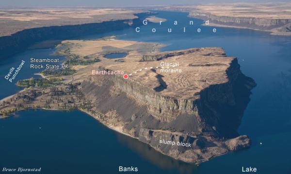
Figure 3. Aerial view of Steamboat Rock
looking south. Ice Age floods removed up to 900 ft of basalt during
the formation of Upper Grand Coulee. The interior of a glacial
moraine (dashed line) is exposed at the Earthcache (see Figure
5).
So why does Steamboat Rock sit out
in the middle of the coulee all by itself (Figure 3) and why
wasn’t it wiped out by flooding like everything else within
this part of Grand Coulee? One reason is that rock blades like
Steamboat Rock are often preserved within the central coulee as
cataracts recede upvalley (Umatilla Rock below Dry Falls is another
example). A second reason is that Steamboat Rock is located where
the coulee widens (Figures 2 and 3) and where the water velocity
and erosion were not as powerful.
Steamboat Rock lies along the
northern boundary of the Columbia Plateau, an area covered with
multiple flows of volcanic Columbia River basalt. Altogether there
were nearly 300 separate eruptions of basalt that spilled into the
Columbia Plateau. The Columbia Plateau was like a giant bowl so
many more flows of basalt exist in the deeper center of the bowl
than around the sides. In the center of the plateau, near the Tri
Cities, the basalt flows altogether are nearly 3 miles thick! In
contrast, only a few flows are present at Steamboat Rock (Figure
4), which lies along the perimeter of the volcanic
plateau.

Figure 4. Granititic basement rock, 40-60
million years old, forms the base of Steamboat Rock, overlain by
several lava flows of younger (~15 million year old) columnar
basalt. That means tens of millions of years of geologic time are
missing between the formation of these two rock types. Geologists
call this large gap in time a hiatus. The contact between these
very different kinds of rock is exposed along the trail to the
summit of Steamboat Rock. The basalt contains many more cracks that
formed as the molten lava cooled and solidified. Ice Age floods
were much more effective at eroding the basalt because of these
cracks.
Two clues reveal the top of
Steamboat Rock was once covered with glacial ice. One clue is
sediment debris called till, piled up into distinctive ridges
called moraines (see Figures 3 and 5). The other clue is erratics -
huge boulders of granite sitting on top of the basalt bedrock
(Figure 6). The moraines piled up in front of the melting glacier,
while erratic boulders were carried down with the slowly advancing
ice sheet and left behind after the glacier retreated. One thing we
know for sure about the glacier that covered Steamboat Rock is that
more Ice Age floods occurred afterwards, since no evidence for
glacial ice occurs in the canyon below Steamboat Rock. Later floods
must have erased this evidence.

Figure 5. The interior of a glacial moraine is
exposed here at the Earthcache. Several meters of unsorted glacial
till making up the moraine were built up in front of the glacier as
it made its final retreat back to Canada many thousands of years
ago. One especially large granitic erratic boulder is visible
within the till deposit.

Figure 6. Like calling cards, erratic boulders
of granite (arrows) sit atop basalt bedrock on Steamboat Rock,.
These tell of a time when its summit was covered with a thick sheet
of slowly moving ice. These erratics were left behind by the
melting ice sheet and not by Ice Age floodwaters. A steep,
sometimes vertical, 800-ft wall of basalt surrounds the
monolith.
View the YouTube video from
the Earthcache.
To recieve credit for this Earthcache answer the following
question: How many glacial erratic boulders are on knoll ~100
yards west of the Earthcache?
Email answer to bjorn99352@yahoo.com