What did exactly happened?
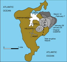
It started in the night, on 23rd January with several weak tremors about one km east from the town. At about 01:55 a fissure opened up on the eastern side of the island and crossing the island from one shore to the other. Spectacular lava fountaining 50 to 150 metres high. Activity soon became concentrated on one vent, about 0.8 kilometre north of the old volcanic cone of Helgafell. The rate of lava and tephra emission from the fissure was estimated to be 100 cubic metres per second. The eruption finally came to an end in early July, when Eldfell was about 220 metres high.
And what was happening during the eruptions on the island?
Firstly, the evacuation started really quickly. There was a plan, developed for a such situation. Some sources said, that the day before eruption, there was such a bad weather around the island, that most of the fishing boats stayed in the harbour. Most of the 5300 inhabitans was evacuated by boats to Thorlakshőfn and the rest of the people (elderly, patients etc.) by planes. All domestic animals died or were slaughtered.
But there was another problem. Flowing lava in to the harbour entrance. If the harbour was destroyed, the island's fishing industry would be devastated. The possibility of lava flows cutting off the harbour was the most significant threat facing the town. The first attempt to slow the lava flow by spraying the leading edge with sea water began on 7 February, and although the volume of water being pumped on was rather small at 100 litres per second, the flow was noticeably affected. By the end of March, thirty-two pumps, each with a capacity of up to 1000 litres per second, were brought in from the USA. After these pumps began to cool the flow advancing towards the town, its movement slowed dramatically and soon stopped. The entrance to the harbor was saved.
The resume
Lava flows also moved into the sea east of the island, creating new land that add over 2 square kilometres to the island, and into the eastern parts of town, destroying several hundred houses. The houses were destroyed by the flowing lava, burned down by fires caused by lava bombs and many houses did not resisted the weight of the ash fall (in the town, there was a layer of the ash 4 to 5 metres thick).
Geological context
The Vestmannaeyjar (Icelandic for Westman islands) archipelago lies off the south coast of Iceland, and consists of several small islands, all formed by eruptions in the Holocene epoch. Heimaey also contains some material from the Pleistocene era. The most prominent feature before 1973 was Helgafell, volcanic cone formed in an eruption about 5,000 years ago.
The Vestmannaeyjar archipelago was settled in about 874 AD and since the settlement, no eruptions had been known to occur on the islands until 1963, when a new member of the archipelago, Surtsey, was formed by a four-year eruption. Scientists have speculated that volcanic activity in the archipelago may be increasing due to the southward propagation of the rift zone which crosses Iceland.
Eldfell is a composite volcanic cone. But what is much more interesting – in year 1990 was found a new mineral on Eldfell. Along with opal and tamarugite, it forms soft and fragile aggregates built of thin, platy crystals of micrometre size. The mineral is yellowish-green to greenish-white, with a white streak.
Source: Loosely constructed with help from www.wikipedia.org
For further information visit these links:
http://en.wikipedia.org/wiki/Eldfell
http://geo.web.ru/Lectures/Plechov/lecture-1/Eldfell.htm
Climb the volcano up to the highest place, where can you have all-round view. When you are climbing up, pick up two lava stones, each with a different color and take an optional photo (on the top of the volcano), where appear you or your team with gps in one hand and the stones in other hand.
Your obligatory tasks:
1) Send me via profile answers for these questions (with your email address):
- describe in simple words, why do you mean, the color of stones is different
- how many houses are on the islands, when you look northern-east from Eldfell, in direction of mainland
- in the surrounding of given waypoint find an information board and tell me, how many degrees of Celsius is still under the surface of volcano. Edit: The info-board disappeared, so please try to find out this info in the town museum, tourist information or via internet.
- tell me the name of new mineral, which is mentioned in the listing
Don´t wait for my permission to log this cache. If there is a mistake, I´ll contact you.