Above coordinates take you to Kirkgate Park, Kinross, on the shore of the loch, where you will find ample parking, a children's playpark, a nearby boathouse bistro and a walk which now takes you all the way round Loch Leven, along which there are more than just a few caches. You can even take a boat trip to Castle Island during the summer months, up until the end of October.
Loch Leven is a fresh water loch in Perth and Kinross council area (formerly Kinross-shire), with the town of Kinross nestled at its western end. It sits in the shadows of the Ochill Hills to the north, the Lomond Hills down its east side and Benarty Hill across its south. The loch itself is a National Nature Reserve and an Important Bird Area.
Loch Leven is probably most famous for being the location where Mary, Queen of Scots was imprisoned in 1567, the full details of which are well documented elsewhere. More recently, in the early 19th Century, the loch underwent a major transformation when the River Leven, located at the loch's south east corner (and its only outlet), was straightened to form a canal for use by nearby mill workings. This caused the water level of the loch to drop by 1.4 metres and as a consequence, much more surrounding land was created and a few new islands were exposed, giving us the seven we see today.
Although the loch's more recent history has been well researched, its origins are a little more unclear. The common belief has been that the loch was formed as a result of glaciation which occurred about 11,000 years ago.
At that time, most of this area was covered by more than a 1 km thick layer of ice and as the last main ice sheet retreated from its maximum extent, meltwaters were released which deposited sand and gravel spreads, or Outwash. Some of these spreads were in the form of mounds and ridges, known as eskers, and a feature of such a landscape was the formation of closed hollows, or Kettle Holes, where buried ice, calved from the main glacier and left behind, melted in situ.
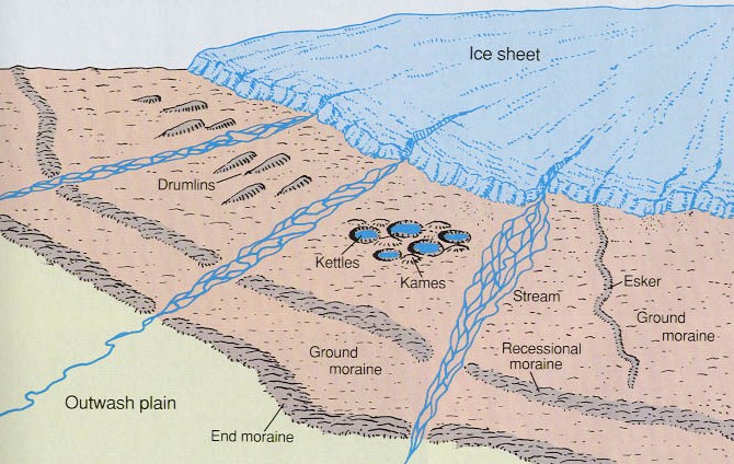
The Formation of Kettle Holes
In most cases Kettle Holes eventually fill with sediment, vegetation, or in this case, water, forming a Kettle Lake. The depth of most Kettle Lakes is less than 10 metres, with the vast majority of Loch Leven being nearer 4 metres deep. Loch Leven was formed as a result of such a glacial process.
Or was it?
Recent research has cast an exciting new light on the possible origins of Loch Leven, with the cause of its formation being not of this World...
Evidence supporting this theory:
1. The River Devon, situated out to the west, forms a complete U turn at Crook of Devon, as a consequence of the same glacial meltwaters which caused the formation of the nearby Rumbling Bridge Gorge. The original course of the river was clearly eastwards, in the direction of Loch Leven. On this basis, the Loch Leven basin therefore existed BEFORE the last Ice Age.
2. The Ochill Hills bear evidence of large quantities of rocks which have been injected in a molten or semi-molten state into the pre-existing volcanic rocks. These intrusive rocks hail from a different era to the rocks they are embedded in.
3. Rocks retrieved from the bottom of Loch Leven were identified as basalt, a dark volcanic rock melted at extremely high temperatures. A substance known as lechatelierite, a type of glass that is formed when quartz melts at temperatures above 1700 degrees was also found.
4. Examination of rocks obtained from a nearby open cast quarry indicate that some of the quartz grains in this rock demonstrate damage to their structure, known as Planar Deformation Features (PDFs).
Only one event is known to cause PDFs and could explain the other inconsistencies described above....

Asteroid Impact!
Asteroids with a 1 km diameter strike the Earth every 500,000 years on average. Large collisions – with 5 km objects – happen roughly once every ten million years. The last known impact of an object of 10 km or more in diameter was at the Cretaceous-Tertiary extinction event 65 million years ago.
As of May 2010, 7,075 near-Earth asteroids are known to astronomers and the number over 1 km in diameter is estimated to be 500 - 1,000. At least one known asteroid with a diameter of over 1 km (29075)1950DA, has a possibility of colliding with Earth on March 16, 2880, so start making plans now!
Objects with diameters over 50 metres strike the Earth approximately once every thousand years, producing explosions comparable to the one known to have detonated above Tunguska in 1908.
Asteroids with diameters of 5 to 10 metres enter the Earth's atmosphere approximately once per year, with as much energy as the atomic bomb dropped on Hiroshima, approximately 15 kilotonnes of TNT. Fortunately, these usually explode in the upper atmosphere, and most or all of the solids are vapourised.
Objects with diameters smaller than 10 metres are called meteoroids (or meteorites if they strike the ground). An estimated 500 meteorites reach the surface each year, but only about 5 or 6 of these are typically recovered and made known to scientists.
According to the theory, rather than collide directly with the Earth, the 80 metre wide asteroid from the Loch Leven Impact Event, would have struck the planet at such a low angle that it would have skimmed across the surface like a stone skimming on water, dredging up rock, liquefying it and depositing the molten debris for miles around, before breaking up completely. In its wake, a crater measuring 13 kilometres long, 5 kilometres wide and 1.8 kilometres deep would have been formed. This would have undoubtedly been a Global Event and it coincided with the disappearance of the great Carboniferous Forest, which covered the Northern Hemisphere.
So, instead of Loch Leven being formed 11,000 years ago through glaciation as previously supposed, the original asteroid crater could have been formed 219 million years ago.
Of course, the subsequent Ice Age would still have manipulated the features of the crater and the loch does have some much deeper Kettle Holes, thought to have been formed at that time in the same manner as described above.
To log this Earthcache, visit Loch Leven and post a photograph of you or your GPS with Castle Island in the background. Then go to co-ordinates N56 12.048 W003 24.353 (you can get a car to within a few metres) where you will find a curved metal Information Bar. Please then email me with the answers to the following questions (please don't post your answers here):
1. There are 7 islands on Loch Leven. From your current location, how many can you see that DO NOT have trees on them?
2. We have already learned about 'eskers' from the description above, but this Information Bar describes another residual formation caused by glacial retreat, also present around Loch Leven. What is it called and give a brief explanantion?
3. One of the islands which appeared here after the loch's water level was lowered in 1830 is named after a bird. Which island is it and which bird gives it its name?
4. What meteoroligical invention was made in this area and by whom was it made?
Regardless of which theory you believe, (and I know which one I prefer!), it does prove that geology is a dynamic science, with new theories and discoveries being made all the time, which can only be a good thing.
Thanks for visiting and keep looking to the skies!

