 Deutschsprachige Version
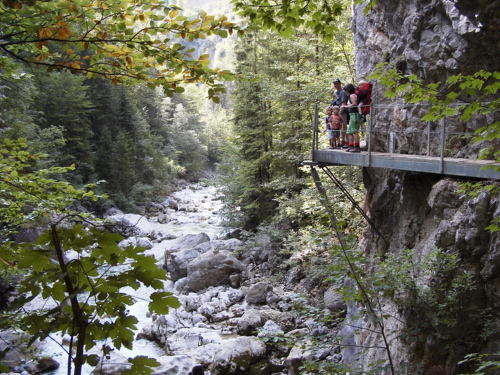
Neben der Kaiserklamm existiert auf dem Gemeindegebiet von
Breitenbach noch eine zweite Schluchtenlandschaft, welche ebenfalls
sehr sehenswert ist - die Tiefenbachklamm. Die Tiefenbachklamm
befindet sich zwischen Brandenberg und Kramsach und ist ein
unvergessliches Stück Naturerlebnis. Die reine Gehzeit durch die
Klamm beträgt hin und retour ca. 1 1/2 bis 2 Stunden.
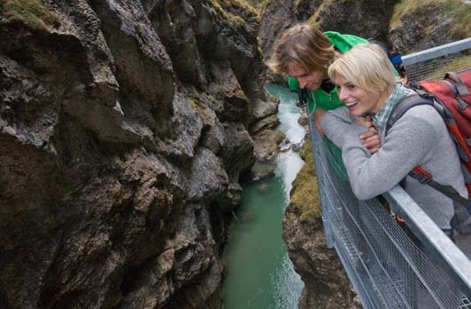
Besonderes Highlight: Die Aussichtsplattform an der
höchsten Stelle der Klamm.
Der Eintritt in die Tiefenbachklamm ist
kostenlos. An starken Regentagen, sowie von November bis April, ist
die Klamm aus Sicherheitsgründen allerdings gesperrt!
Geologie
Klammen sind magische Orte, an denen das Land gespalten und
Berge geteilt sind. Die alpinen Schluchten wurden in der letzten
Eiszeit vor etwa 10.000 Jahren gebildet und haben sich seitdem
stetig verändert, wenn auch nur sehr langsam. Zeit und Wasser
formten und modellierten ihre schroffen Wände über die
verschiedenen Jahreszeiten. Unmittelbar nach dem Winter beginnt das
große Tauen. In dieser Zeit donnern gigantische Mengen an
Wildwasser selbst durch die engsten Stellen in den Alpen und graben
sich immer tiefer in den Fels. Im gleichen Moment, in dem sich die
Gewalt der Natur in ihrer vollen Kraft entfaltet, bereitet sich
dieses Schauspiel bereits für das nächste Jahr vor. Der Kreislauf
beginnt von vorne.
Die Brandenberger Ache durchbricht mit zwei begehbaren
Schluchten die beiden wichtigsten Gesteine der nördlichen
Kalkalpen: Mit der Kaiserklamm nördlich von Brandenberg den
Wettersteinkalk und mit der Tiefenbachklamm weiter südlich nahe
Kramsach den etwas jüngeren Hauptdolomit. Zwischen den beiden
Klammen, bestehen die Berghänge aus ca. 80 Millionen Jahre alten
Gosauschichten. Da diese hier großteils durch weichen Sandstein
aufgebaut werden, verwittern sie leichter und das Tal wird
weiter.
Beim Blick taleinwärts in die Tiefenbachklamm erkennt man gut
den nach rechts in schrägen Schichten abfallenden Dolomit. Der
Moränenschutt am Boden enthält dagegen sehr viel kristallines
Urgestein, das im Kalkgebiet an sich nicht vorkommt. Der
Inntalgletscher hat hier in der letzten Eiszeit allerlei Geröll aus
den Zentralalpen abgelagert, woraus man schließen kann, dass die
Klamm schon recht alt sein muss. Wie die Dolomitbildung vor sich
ging, ist bisher noch nicht völlig geklärt. Die häufigste Form ist
der "Hauptdolomit". Dieses 200-220 Millionen Jahre alte Gestein aus
der Obertrias gehört zu den verbreitetsten Felsen der Kalkalpen und
ist etwas jünger als der Wettersteinkalk.
Logbedingungen
Um diesen Earthcache loggen zu
dürfen, musst du zuerst drei Aufgaben lösen. Wir empfehlen die
Aufgabe 1 auf dem Hinweg, die Aufgabe 2 auf dem Rückweg und die
Aufgabe 3 begleitend zu absolvieren! Um die Aufgaben erfolgreich zu
meistern, musst du vor Ort gewesen und die Klamm komplett gegangen
sein. Es ist also nicht ausreichend Fotos vom letzten Urlaub
hochzuladen oder die Antworten auf die gestellten Fragen im
Internet zu recherchieren!
Um dir die Orientierung innerhalb der Klamm zu erleichtern,
haben wir die Abstände von Header-Koordinaten und den einzelnen
Stationen mit angegeben. Diese Abstände verstehen sich immer als
Luftlinie zwischen dem in den Header-Koordinaten angegebenen
Einstieg in die Klamm und der Position der zu lösenden
(Teil-)Aufgabe. Wir empfehlen die Header-Koordinaten in deinem
GPS-Empfänger eingestellt zu lassen und so lange auf dem Weg
weiterzugehen, bis die angegebene km-Zahl erreicht ist. Anhand der
Aufgabenbeschreibung solltest du die Stationen eindeutig erkennen
können, wenn du sie erreichst! Es ist also nicht notwendig ständig
neue Koordinaten einzugeben, genieße stattdessen lieber die
Schönheit der Natur um dich herum :-)
Aufgabe 1
Um dir die Wartezeit auf die übliche Logfreigabe zu ersparen, haben
wir eine Automatisierung vorgesehen. Ziel dieser Aufgabe ist es,
die E-Mail-Adresse für die automatische Logfreigabe herauszufinden.
Die E-Mail-Adresse setzt sich aus drei Teilen zusammen, die du wie
folgt bestimmen kannst:
1. a) nach 1,47 km (N 47° 29.477 E 011°
52.466)
Unweit der Aussichtsplattform findest du eine Gedenktafel mit einem
Datum darauf. Notiere dir die Jahreszahl dieses Datums als
AAAA.
1. b) nach 1,76 km (N 47° 29.586 E 011°
52.663)
An dieser Stelle findest du ein verfallenes Gebäude. Notiere dir
die Jahreszahl oberhalb des Eingangs als BBBB.
1. c) nach 2,51 km (N 47° 29.864 E 011°
53.134)
Hier befindet sich eine Brücke, eindeutig erkennbar an den
achteckigen Aussparungen in Form des Verkehrszeichen für "Stop!" an
ihrer Unterseite. Unterhalb dieser Brücke erkennst du eine kleine
Plattform, die auf der Südost-Seite über eine kurze Leiter im Fels
erreicht werden kann. Klettere auf diese kleine Plattform und
notiere dir das deutschsprachige Wort, das du dort
an der Unterseite der Brücke findest als
CCCCCCCCC.
Aufgabe 2
Innerhalb der Tiefenbachklamm ist der Hauptdolomit allgegenwärtig.
An den folgenden Positionen ist dieser besonders gut erkennbar.
Notiere dir für alle drei Positionen in welcher Himmelsrichtung
sich der Hauptdolomit ungefähr befindet. Beispiel: 2. a) N, 2. b)
SW, 2. c) NE
2. a) nach 1,65 km (N 47° 29.557 E 011°
52.555)
Du stehst hier auf einer Brücke, den Hauptdolomit findest du auf
der anderen Flußseite.
2. b) nach 2,20 km (N 47° 29.743 E 011°
52.947)
Zwischen den Zweigen hindurch solltest du von hier aus den
Hauptdolomit auf der anderen Seite des Flusses besonders gut
erkennen können.
2. c) nach 2,51 km (N 47° 29.864 E 011°
53.134)
Unter dieser Brücke findest du auch die Antwort auf Frage 1. c).
Findest du auch den Hauptdolomit?
Sende uns deine Antworten per E-Mail. Sollten die angegebenen
Himmelsrichtung grob abweichen, werden wir uns bei dir melden.
Aufgabe 3
Deine letzte Aufgabe ist es deinen Weg durch die Tiefenbachklamm
mit mindestens drei Fotos festzuhalten und deine Eindrücke im Log
festzuhalten. Die Fotos sollten dich bzw. dein Team und/oder deinen
GPS-Empfänger an für dich besonders schönen, interessanten, oder
spektakulären Stellen der Tiefenbachklamm zeigen. Bitte sende uns
die Fotos nicht per E-Mail, sondern hänge diese an dein Log an!
Weitere Fotos sind natürlich willkommen ;-)
Wieder zuhause sende uns eine kurze E-Mail mit dem Namen deines
Teams gemeinsam mit dem Datum, an welchem du die Aufgaben gelöst
hast und deiner Antwort zu Aufgabe 2, an folgende Adresse:
AAAA-BBBB-CCCCCCCCC@mus162.com
"AAAA-BBBB-CCCCCCCCC" ist ein Platzhalter, den
du natürlich erst durch die Antworten auf die gestellten Fragen aus
Aufgaben 1. a) bis 1. c) ersetzen musst. Falls deine Antworten
korrekt waren, erhälst du sofort eine automatische
Logreigabe zurück. Danach darfst du deinen Besuch der
Tiefenbachklamm loggen. Bitte dank daran, die drei obligatorischen
Fotos aus Aufgabe 3 an dein Log anzuhängen!
Logs ohne Logfreigabe bzw. Fotos werden
kommentarlos und ohne Ausnahme wieder gelöscht!
 Anglophone Version
Apart from the "Kaiserklamm" (= Emperor Gorge) in the
municipality of Breitenbach there exists a second canyon, which is
also well worth seeing - the "Tiefenbachklamm" (= Deep River
Gorge). The Tiefenbachklammm is located between Brandenberg and
Kramsach and is an unforgettable piece of nature. The hike through
the gorge and back again takes about 1 1/2 to 2 hours.
An unforgettable experience for the whole
family.
The entrance into the Tiefenbachklamm is
free of charge. On days of heavy rain and from November to April
the gorge is closed for safety reasons!
Geology
Gorges are magical places, where the land is split and mountains
are divided. The alpine canyons were formed in the last ice age
around 10,000 years ago and have being changing ever since, albeit
ever so slowly. Time and water has shaped and sculptured their
curved walls with the seasons. Right after the winter the big thaw
begins, which amounts to a sudden thunder of white water gushing
through the narrowest parts of the Alps and constantly digging
deeper into the rock. The noise of nature, in full force relieves
itself as it prepares itself for the next season. The cycle begins
again.
Within two walk-in canyons the Brandenberger Ache breaks through
the two main rocks of the northern Alps: The Kaiserklamm north of
Brandenberg mostly consists of a special kind of limestone called
"Wettersteinkalk" and the Tiefenbachklamm to the south near
Kramsach is formed of the slightly younger main dolomite. Between
the two gorges, there are mountain slopes with about 80 million
years old "Gosau" layers. Since these are here largely built up by
soft sand stone, they weather easier and the valley is getting
wider.
By looking into the valley of the Tiefenbachklamm one can well
see the sloping diagonal layers of dolomite on the right side. The
moraine at the bottom constists of crystalline bedrock, that does
not typically appear as such in the limestone region. The Inn
valley glacier has deposited it here during the last ice age from
all kinds of debris from the Central Alps, from which one can
conclude that the gorge has to be quite old. How the dolomite
formation was going on, is still not fully understood. The most
common form is the "main dolomite". This 200-220 million year old
rock from the Upper Triassic is one of the most common rocks of the
Limestone Alps and is slightly younger than the
Wettersteinkalk.
Logging Requirements
To log this cache, you first need
to solve three tasks. We recommend to complete task 1 in one
direction through the gorge, task 2 on the way back and task 3
accompanying along your way! To successfully solve the tasks, you
must have been at the site recently and have walked through the
gorge completely. It is not enough to upload photos from your last
vacation or to research the answers to the given questions on the
internet!
To help you keeping your orientation within the gorge, we have
tracked the distances from the header coordinates for each stage.
The distances should be interpreted as beeline between the given
header coordinates at the entry into the gorge and the position on
which the (sub-)tasks have to be solved. We recommend you to keep
the header coordinates selected on your GPS receiver and to walk
along the trail until the specified distance is reached. Based on
the task description you should clearly perceive the stages when
you reach them! So there is no need to constantly set new
coordinates, instead you should enjoy the beauty of nature around
you :-)
Task 1
In order to spare you the wait time to the usual log approval, we
have provided some kind of automation to this. The goal of this
task is to assemble the e-mail address needed for the automatic log
approval. The e-mail address is composed of three parts, that you
can determine as follows:
1. a) after 1.47 km (N 47 ° 29 477 E 011 ° 52
466)
Not far from the viewing platform you'll find a memorial plaque
with a date on it. Write down the year of that date as
AAAA.
1. b) after 1.76 km (N 47 ° 29 586 E 011 ° 52
663)
At this point, you'll see a ruined building. Write down the year
above the entrance as BBBB.
1. c) after 2.51 km (N 47 ° 29 864 E 011 ° 53
134)
At this position there is a bridge that is unambiguously
recognizable by the octagonal recesses in the form of the road sign
for "Stop!" on its underside. Right below this bridge there is a
small platform that can be reached from the southeastern side of
the brige over a short ladder in the rock. Climb up on this little
platform, and write down the english-language word
that you'll find there on the underside of the bridge as
CCCCCCCCC.
Task 2
Within the Tiefenbachklamm the main dolomite is ubiquitous. At the
following locations it is especially clearly visible. Write down
for all three positions in which cardinal direction the main
dolomite can be seen approximately. Example: 2. a) N, 2. b) SW, 2.
c) NE
2. a) after 1.65 km (N 47 ° 29 557 E 011 ° 52
555)
As you are standing on a bridge, the main dolomite can be found on
the other side of the river.
2. b) after 2.20 km (N 47 ° 29 743 E 011 ° 52
947)
From here you should have a good sight on the main dolomite on the
other side of the river.
2. c) after 2.51 km (N 47 ° 29 864 E 011 ° 53
134)
On this bridge you will find the answer to question 1 c). Can you
also discover the main dolomite?
Send us your answers by e-mail. If your measured directions are
roughly off, we will contact you.
Task 3
Your final task is to document your way through the Tiefenbachklamm
with at least three photos and write down your impressions in your
online log. The photos should show you resp. your team and/or your
GPS receiver at your favorite, most beautiful, interesting, or most
spectacular points of the Tiefenbachklamm. Please do not send us
your photos by e-mail, but add these to your online log! More
photos are welcome ;-)
Back home send us a brief e-mail with the name of your team
together with the date when you've solved the tasks and your answer
to task 2 to the following address:
AAAA-BBBB-CCCCCCCCC@mus162.com
"AAAA-BBBB-CCCCCCCCC" is a placeholder. Of
course you have to replace it by the answers to the questions of
task 1. a) to 1. c) first. If your answers were correct you should
get an automatic log approval immediately. Then
you are allowed to log your visit of the Tiefenbachklamm online.
Please attach the three obligatory photos of task 3 to your log as
well!
Logs without a valid log approval or
photos will be deleted without exception and comment!