Gum
(Friendship) Spring is located
on KY Hwy 453, 6.2 miles (7 minutes) south of Smithland and
8.5 miles (14 minutes) north of Grand Rivers. It is located across
the highway from Friendship Baptist Church. There is parking
at the spring.
To Log this earthcache, complete the
following:
1.
|
Send me an email with the
following information (do not post answers with your on-line
log): |
|
A.
|
What is the temperature of the spring? Is it below or
above the current air temperature. |
B.
|
The flow of the spring is from (choose one): a. under a
bridge. b. from under the road or c. from under the spring
house. |
C.
|
What is direction (in degrees) of the flow of the spring?
Use your GPSr to take a heading. |
D.
|
Look up the
precipitation for the past year in
Grand Rivers and compare it to the magnitude/flow from the
spring that you observe. (You will need to bring a measuring device that you know
the amount the device will hold.) |
|
2.
|
(Optional) Post a picture of yourself and your
party with GPSr in hand and sitting beside the
spring. |
Natural Springs
of Livingston County:
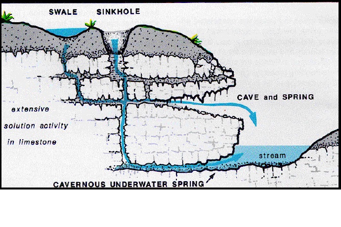
Limestone
springs, such as Gum Spring, are located throughout Livingston
County. Springs occur at the base of many limestone formations
where they crop out on escarpments and hillsides. Ground
water is replenished through the water cycle via sink holes.
Sinkholes are common karst features
throughout Livingston County. Sinkholes commonly form in row crop
fields as small openings, 1 to 2 feet in diameter, as seen above.
Spring Water moves downhill through soil or cracks in rock until it
is forced out of the ground by natural pressure. The amount,
or yield, of available water from springs may vary with the time of
year and rainfall. Groundwater obtained from springs is similar to
water pumped from shallow wells.
Dependent upon
the constancy of the water source, a spring may be ephemeral
(intermittent) or perennial (continuous). When water issues from
the ground it may form into a pool or flow downhill, in surface
streams. Most of the limestone springs in Livingston County flow
year around and are used as drinking-water sources.
Minerals become
dissolved in the water as it moves through the underground rocks.
This gives the water flavor and even carbon dioxidebubbles,
depending upon the nature of the geologythrough which it passes.
Springs that contain significant amounts of minerals are sometimes
called 'mineral springs'. Springs that contain large amounts of
dissolved sodiumsalts, mostly sodium carbonate, are called 'soda
springs'.
Gum Spring: Spring or Seep? Artesian or
Gravity? Cool or Thermal?
Water which
emerges at the surface naturally with a distinct current is called
a spring. When a
distinct current is not present, the flow is called a seep. Most springs and seeps
represent water from rain or snow on some nearby higher ground
which moves underground to where it comes up out of the ground. In
some springs, the water bubbles up with a measurable force,
indicating that it is under pressure, these are called artesian springs. Any spring
having a temperature higher than the yearly average temperature for
a given region is termed a thermal spring. This indicates
a source of heat other than that of the surface climate, of which
magmatic heat is an example. Based upon the pressure of the
emergent water, any spring or seep which is not artesian may be
classified as the gravity type. Gravity springs
and seeps are those in which subsurface water flows by gravity from
a high point of intake to a lower point of issue.
Discharge
Classification
The amount of
water that flows from springs depends on many factors, including
the size of the crevices or caverns within the rocks, the water
pressure in the aquifer, the size of the spring basin, and the
amount of rainfall. If the groundwater is under sufficient
pressure, the spring (or a well) might shoot water into the
air-artesian well or spring. Human activities also can influence
the volume of water that discharges from a spring—groundwater
withdrawals in an area can reduce the amount of water and the
pressure in an aquifer, causing water levels in the aquifer system
to drop and ultimately decreasing the flow from the
spring.
Magnitude
|
Flow (ft³/s, gal/min, pint/min) |
Flow (liters/s)
|
1st
|
>100
ft³/s |
2800
L/s
|
2nd
|
10 to 100
ft³/s |
280 to
2800 L/s
|
3rd
|
1 to 10
ft³/s |
28 L/s to
280 L/s
|
4th
|
100 US
gal/min to 1 ft³/s (448 gal/min)
|
6.3 to 28
L/s
|
5th
|
10 to 100
gal/min
|
0.63 to
6.3 L/s
|
6th
|
1 to 10
gal/min
|
63 to 630
mL/s
|
7th
|
1 pint to
1 gal/min
|
8 to 63
mL/s
|
8th
|
Less than
1 pint/min
|
8
mL/s
|
Zero
|
no
flow
|
no
flow
|