Arkansas Coal Mine's EarthCache
-
Difficulty:
-

-
Terrain:
-

Size:  (other)
Please note Use of geocaching.com services is subject to the terms and conditions
in our disclaimer.

HOW COAL WAS FORMED
According to the American Coal Foundation Coal was formed in the
following matter. Scientists believe that during the Carboniferous
period (280 to 345 million years ago) large amounts of plant life
and other organic matter grew in the swampy areas and lagoons that
covered much of the earth. As the plants and other life forms died,
they drifted down to the bottom of the swamps, slowly decomposed,
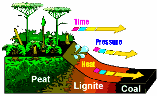
and formed peat—a soggy, spongelike material. The peat became
buried and compressed under the earth's surfaces over a long period
of time. Over millions of years and through the forces of heat and
pressure, the compressed peat became coal. The greater the heat and
pressure, the harder the coal was that formed Coal is now
classified into four different categories. The differences in the
types of coal are based on the amount of carbon in the coal and how
it responds to increasing heat and pressure beneath the
earth’s surface.
The Four Type's of Coal are
Lignite, Subbituminous, Bituminous and Anthracite.
Coal fields in Arkansas are located in the Arkansas River Valley
between the western border of the state and Russellville (Pope
County) Until about 1880, most coal mined in Arkansas was used near
its original location, often to fuel the fires of blacksmiths.
Between 1880 and 1920, coal was Arkansas’s first mineral/fuel
output, used especially for locomotives and steam-powered machines,
as well as for heating homes and businesses. After 1920, oil and
oil byproducts pushed aside the popularity of coal as a fuel, and
mining of coal decreased. Much of the coal mined in Franklin County
and Sebastian County around the year 2000 was used in the
manufacture of charcoal briquettes for outdoor cooking. However,
rising oil prices in the twenty-first century have led to increased
interest in burning coal to generate electricity. The thickness of
the coal beds in Arkansas rarely exceeds nine feet. The fields are
often small because the coal beds are lenticular and may have been
folded, faulted, or eroded during or after deposition. Arkansas
River Valley coals vary from one type in the western portion of the
area to another type in the eastern portion. One of the principal
advantages of Arkansas coal is that it gives off little smoke when
it burns. Another advantage is low sulfur content as compared to
many coals mined in the United States. Because of its high carbon
content, Arkansas coal is a more efficient fuel than coal from
other parts of the country—Arkansas coal has been rated at
13,000 to 15,000 BTU, as compared to 7,500 BTU for
Pennsylvania
The coal mining industry has been a part of the history and growth
of Paris, Arkansas almost from its beginnings. At first, coal was
only for local use. With the coming of the railroads, coal mining
became a major industry.
The first coal mine near Paris was located near Short Mountain
Creek in 1880.This mine was called the “Lone Star” The
coal sold at seventy-five cents a bushel. .
The Coordinates at the top will take you to the Paris Coal Miner's
Memorial Where you will need to search the plaque for answer to
the.following Question.
#1.What year was coal found in Logan County?
#2.What year did commercal mining begin?
#3.What is the number found on the bottom left hand corner of the
patent tag on the steam engine ?
#4. What is the date on the Seal in the middle of the
Memorial?

You will need to send me a email wth your answers in order to claim
a find on this cache
Please do not post your answers in your online log
Feel free to post a photo of yourself at the Memorial if you so
chose to do so.
Additional Hints
(No hints available.)