The 'Roaring Linn' in the Moffat
hills:
Grey Mare's tail waterfall in the Moffat Hills, or 'the Roaring Linn' as it is referred to locally drops some 200 meters to the main valley floor below, making it one of the highest waterfalls of this type in Britain, The water flows from down from Loch Skeen, which is the highest large, natural upland loch in the Southern Uplands, sitting at over 500 meteres (1,640ft) above sea level, the water flows into into the 'tail burn' which then plunges over the edge into the valley below and into the Moffat water.
To complete this cache after reading the cache page (it will help you!) please go to the first waypoint (the main cache coordinates) and follow the instructions given later in the 'logging requirements' section
Geology of the area and how the falls were formed:
At the main coordinates you will find yourself
standing at the bottom of the valley, looking upwards to the falls in the distance, the hills all around you that you can see here were sculpted by glaciation during a series of Ice Ages between 2 million and 15,000 years ago, glaciers (massive ice rivers) slowly ploughed thier way through the landscape, gouging and scraping out the ground beneath them as they went with the boulders and rocks they carried with them see diagram below) , the deep 'U' shape that you can see here in the Moffat water valley was actually carved out by one huge glacier, this process is known as 'glacial abrasion'

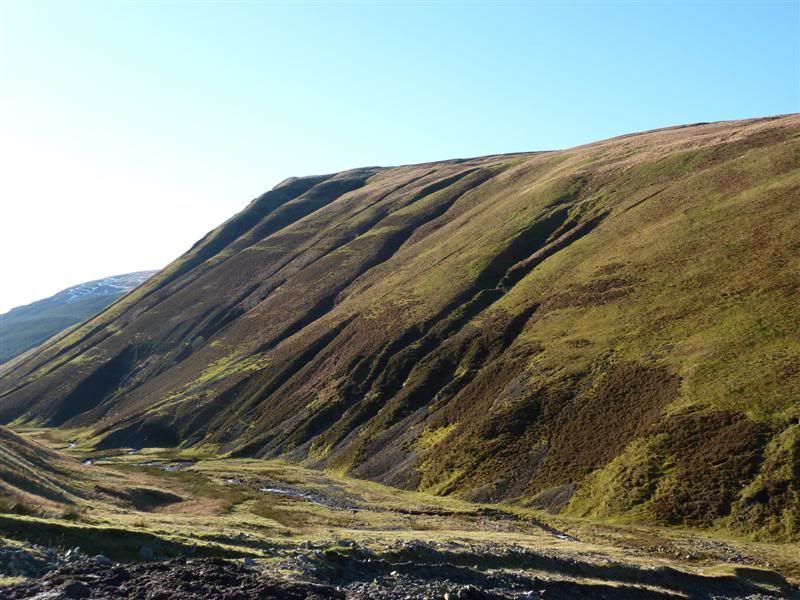
The smaller side valleys, like the one the tail burn flows down were carved out by much smaller glaciers, the tail burn (which is basically the name for the flow of water down from Loch Skeen) would have flowed across ground, after the huge glacier had melted and receded back into the hills the valley had been formed, what was left is now known as a 'hanging valley' leaving the tail burn a 200 meter drop down to the valley floor which would not have been present before the visit of the huge glacier, hence the waterfall was now formed !

If you decide to continue the walk further up to Loch Skeen (recommended but not necessary to complete the cache) you will see mounds of boulders, these are were deposited when the glacier left, they would have been carried along within the huge ice sheets andwhen the glacier melted they were simply left exactly where they were to remain forever, this process can often leave some huge rocks deposited in areas that do not naturally have this type of rock, these rocks or boulders are known as erratics for that reason
The last major period of glaciation when most of Britain was covered in ice ended around 15,000 years ago as previously mentioned, however here in the Scottish Lowlands there was also the Southern outpost of another Ice Age (albeit smaller than the last) about 5,000 years later, this was known as the Loch Lomond re-advance.
There are also some very evident landslips to be seen in the area to be seen, there are 2 very prominent ones that you will not need a waypoint to find !
The way that glaciers moved and forced thier way through the land often led to many differing features being left behind in thier wake, what they left behind in areas with running water woulddetermine what type of waterfall would be formed, there are many different types of falls, below are the waterfall classifications, and also an explanation of how to identify them by their unique features.

Waterfall Types:
Plunge: Waterfalls that drop vertically usually without touching the underlying cliff face fall under this category. Waterfalls typically well into the evolution of waterfall formation evolve into this category Sometimes you can even go behind these types of waterfalls, such as in the Brecon Beacons and at Ingleton Falls in the Yorkshire Dales.
Horsetail: These waterfalls fan out as they drop into a steep slope but maintaining contact with the underlying cliff face usually fall into this category. The name of this category derives from the fact that some might observe the shape the waterfall under this circumstances actually resembles a 'horse's tail'. These types of falls are either younger than the plunge type or the hard rock layer is steeply sloped.
Fan: Waterfalls in this category are quite similar to that of the Horsetail variety as mentioned above. They share the common characteristic in that the waterfall drops and slides along a steep slope while consistently maintaining contact with the underlying cliff. However, the difference is that the shape of the waterfall is such that it looks more like a fan shape facing upside down.
Punchbowl: This describes the shape you get when you have a stream chanelled into a narrow hanging gorge and shooting over a drop that results in a deep plunge pool resembling a punch bowl. It is not uncommon for the pool to be deeper than then fall itself.
Block or Rectangular: These are the types of waterfalls that have a kind of rectangular shape. The underlying cliff face is usually a vertical wall. Sometimes waterfalls in this category end up being wider than its height. Usually, the wider the river that's plunging, the wider the waterfall and hence the fatter the rectangle. A good example for you to picture this would be Niagra Falls in Canada.
Tiered: These waterfalls have more than one vertical leap or simply put, tier to them from the perspective of one vantage point.
Segmented: Thiscategory of waterfalls have the falling water splitting up into two or more parallel segments Usually the cause of the split is some protruding rock in the middle of the falling water before or during the course of the waterfalling cascade.
Cascades: These waterfalls basically descend along a sloped surface. The falls could be in the early phase of its evolution or the underlying hard rock layer is sloped and water is moving along it. Sometimes you get stepped formations if the individual tiers are too small to count as a tiered waterfall.
Chute: Waterfalls in this category are typically where the falling water is forced into a narrow channel resulting in a violently pressurized ejection of water.
Scree: scree waterfalls flow over loose rock that has accumulated at the base of a mountain or cliff as a result of erosion.
Ribbon: These fall usually fall over a long vertical drop resulting in their ribbon-like appearance. You would usually see this type on mountainous areas where the water falls straight off a ledge and does not contact any rock or obtacle before hitting the ground.
Additional information about the area:
There is a large car park here, which has a £2 charge towards the National Trust for Scotland, here you will also be able to pick up an information booklet (all year round) to guide you on your walk,this will help pick out the features within the valley, in Summer months there is a rangers trailer parked here manned by NT Scotland staff and volunteers, who will be pleased to assist you with any information you may need on the site, also they have a CCTV link to a nearby Peregrine Falcon nest ! It is also possible for a small number of cars to park for free further down the road going away from Moffat direction.
The walks:
To complete the cache alone should take you no more than 15 minutes, although you may well want to spend longer exploring this superb place and extend the walk (highly reccomended! ) the cache walk involves you walking up a steep section of the path to the LEFT of the fall from the viewing point (you will reach a dead end there from where you may view the falls safely) , to continue the walk up to Loch Skeen and beyond to White Coombe at 821 meters (the highest hill in Dumfrieshire) you will need to take the RIGHT hand side path from the viewing point, whichever route you decide to do, sturdy footwear will be required as the ground is steep and uneven in parts, again maps of the routes can be found in and around the car park and also in the information book that is available.
What do I have to do to log this cache ?
Ok, so this being an Earthcache you are required to perform some tasks whereyou will show that you have gained information from your visit that has enabled you to learn about the area here, the processes that created it, and the reason for it looking as it does today, ALL the information you need to answer the questions can be found both on the 3 information boards at waypoint 1, again in the information booklet available, from reading the cache page itself in conjunction with the area, and of course from what you see here, you do not have to search the internet for any information it can all be found around you, and you do not need to leave any footpath at any time.
The answers should be EMAILED to me through my profile and should not appear in your logs, any logs without the requirements met may be deleted.
1. At waypoint 1 - look about a third of the way up the hillside, what do you see here and what does it tell us about the last glacier that was here ?
2. Explain the definition of a 'Moraine' (alternative name given at the waypoint) , and how they appear in this landscape
3. At waypoint 1 - Reading the waterfalls description that I have provided for you, look at the falls and tell me what type of fall this is by its features, once you have your answer you may check it against some information to be found at waypoint 1, say in your log if you were correct or not.at the time
Now leave the viewing area and take the path off to the LEFT to waypoint 2
(please note that if you wish to do the extended walk you may also complete these tasks by taking the very steep path to the right and do the tasks before you reach the very top - photo's at the top also welcomed)
4.At waypoint 2 - what is to be seen 100ft to the right of the main fall, explain how it has been formed.
5.At waypoint 2 please provide a photograph of yourself / gps with the falls in the background -
photographs are welcomed in your logs and provide a great viewing platform for other potential visitors.
I hope you enjoy your visit to the Grey Mare's Tail Nature reserve, please always observe the country code and keep to the footpaths were possible if doing the longer route.
PLEASE NOTE: I receive a very high number of Earthcache emails, I can’t reply to them all otherwise I’d be doing nothing else all day, as has always been the case there is no need to await a reply from me regarding your answers…. However due to numerous people thinking they can just log these caches without emailing any answers, and/or completing the required tasks these will be picked up, and the logs will be deleted without further communication. To facilitate this Please email your information either before, or AT THE SAME TIME OF LOGGING THE CACHE, Thanks.