Recently, I took an introductory geology class and learned much about the geologic history of the Monterey Peninsula. This cache is part of a series that I hope will help educate those who enjoy our beautiful local environment.
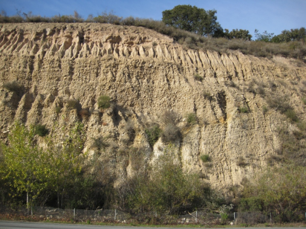
Carmel Valley is intimately tied to the Carmel River. The road cut at this cache site beautifully exemplifies both the past,present, and future of the valley. Starting from the bottom of the outcrop, two distinct types of rocks are evident. First, the lowest layer is the Monterey Formation seen throughout the area. This layer forms in deep marine basins far from continental shelves.
The following layers, the large cobbles with a sandstone like layer separating the individual repeats, gives us clues about the origin of these rocks. Being well rounded and having a variety of sizes, we can compare these cobbles to those that we might currently find in the Carmel River. What we would find are not only similar cobbles, but the same type of energy environment needed to create such rocks. Further from the river, we would find large plains, not unlike the large plains one might see in the valley looking down from this cache spot. Like most things in nature,rivers change course throughout their life. The flood plains are not just a result of periodic flooding, but also from the river meandering accordingly with the environment. As a result, we see sandy layers in the outcrop when the river decides to change course.
For Verification, please send me:
1.)An email with the line "GC2JWVP Geo Lab - Carmel Valley Geologic History" in the beginning.
2.) Your thoughts on how this outcrop ended up in a hillside rather than the valley floor.
3.) Your thoughts on why the lowest layer is tilted while the following layers are laid flat.
4.) The number of rivets attached to a joining section of road barrier with the reflector near GZ
I've listed my answers in the hint section. No cheating! :-)
Other Caches In This Series:
Geo Lab - Anticline
Geo Lab - The Monterey Formation
Geo Lab - Pillow Basalts
Geo Lab - San Gregorio Fault (Earthcache)