You’ve seen the big granite boulders along
the beach, on the side of Lion’s Head, and even in Paarl.
Seasoned Cape geocachers have learned a bit about the cape granites
from other earthcaches (for example:
Froggy Pond Boulder Hop,
Darwinian Contact &
Paarl Rock ), but how did these big bubbles of stone end up
looking the way they are? Where did they come from? The answer is
erosion. Different kinds of rocks erode differently, and at this
earth cache location you will be able to see granite in the process
of eroding.
When the Cape Granites intruded into the
Malmesbury shale, deep under the earth, around 540 million years
ago, they were liquid rock. They cooled slowly forming massive
bodies of granite with large crystals of feldspar, called
megacrysts because they are so unusually large. These bodies of
granite were huge, mountain sized pieces of rock. Later, the Table
Mountain Sandstones (TMS) were deposited on top of these rocks.
But how did these mountain-sized pieces of granite end up as the
characteristic bubble shaped boulders that are so prominent around
the peninsula? They didn’t roll there. Rocks are broken down
by different kinds of erosion into smaller particles that
eventually form sand and dirt. For the granite around Cape Town,
the two most important factors of erosion are fracturing and
chemical weathering caused by water.
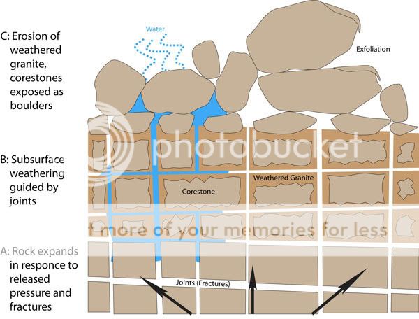
When a body of rock is uplifted, and the layers
above are eroded away, a great weight has been lifted off their
backs. This causes fracturing to occur and joints to appear (See
Figure: A). Water seeps into these joints eroding the rock at these
seams. The more water that can get in, the faster the crack widens.
The large feldspar crystals are altered by acidic water and become
kaolinite, a soft clay mineral. The once rock hard granite can now
be crushed with your bare hands. The resulting kaolinite is mined
around the Cape Region for making ceramics and glossy paper. The
granite blocks that do not erode away are left in place and
referred to as corestones.
At the cache location there is a road cut where
you can see corestones of solid granite in place surrounded by the
transformed eroded granite (See Figure: B). At the cache location,
or maybe in the parking lot next to it to avoid the cars, take a
handful of this eroded granite and crush it in your hand. You will
be able to see the components of granite and the fine powder of the
kaolinite.
Now if you look up at Lion’s Head from the
cache location, you will be able to see large granite corestones
exposed on the surface of the hill. Unlike the corestones that are
still buried in the road cut, these rocks are rounded like those
down at the beach. Why does that happen?
The answer is in the nature of the rock. Granite
is an igneous rock, this means it was molten before it formed.
Unlike sedimentary rocks, that are laid down in layers, igneous
rock does not have any internal structure for cracks to appear in a
regular, predictable way. As a result, when granite weathers, it
exfoliates (See Figure: C). What this means is that it peels off in
layers like the skin of an onion, resulting in a rounded shape.
There are also granite boulders that while
rounded, also seem to be hollowed out inside. I saw quite a few of
these near
Blood Sweat and Sandy Bay recently with Cism. There is also a
stunning example up by the picnic table at
Shrek's Boulder and these kinds of rocks can be found many
other places around the cape. Apparently these unique features are
formed when there is a pervasive wind direction in addition to the
usual methods of eroding granite. As CapeDoc knows, Cape Town has a
pervasive wind direction. What happens is that the water on one
side of the boulder is dried quickly by the wind, and the other
side stays wet longer. This causes the downwind side of the boulder
to erode faster. Once started, a concavity forms and becomes its
own wind shadow, increasing the rate of erosion. Over time, the
rounded granite boulder becomes a hollowed out shell, forming a
perfect hidey hole to place a cache.

To log this earth cache, please email me the answers to the
following questions:
- Based on your direct observations, did the granite here cool
slowly or quickly? How do you know?
- What colour is the powder produced by crushing the eroded
granite?
- Why does granite erode into balls instead of into slabs?
- What will happen to the blocky corestones in the road cut when
the surrounding degraded granite eventually erodes away?
- If you want, take a picture of yourself or your GPS at the EC
location and include it in your log, (THIS IS OPTIONAL)
Sources and further reading:
Compton, J.S. 2004. The Rocks & Mountains of Cape Town.
Double Story, Cape Town.
http://en.wikipedia.org/wiki/Marine_geology_of_the_Cape_Peninsula_and_False_Bay
http://www.travelwild.com.au/the-wild-guide/geology-of-remarkable-rocks-kangaroo-island.php
