*****************************************************************
TO LOG THIS EARTHCACHE: e-mail me (do Not post in your log) the answer to at least ONE of the following questions (OPTION: you can post a photo [of you if you wish] at the geocache, preferably with your GPS in place of an answer): You do NOT need to wait for a response from me.
Because this can be a busy road, A PHOTO CAN BE ANYWHERE AT THE LOCATION AREA (e.g. with the Blue Ridge Parkway sign), YOU do *NOT* have to cross the road to be at the ECD sign!!
1.) From your observation of the sign found at the cache location,
What is the elevation at this point of the Continental Divide? _______ft.
2.) According to the definition of a divide, this point should be at a higher elevation than the surrounding land. a): IS IT? ________. b): If not, explain why _______________.
3.) Drive up onto the Parkway, and, using your GPS:,
As you drive across the bridge, safely observe the elevation.
a): Does it change as you cross the area of the divide? ____________.
b): Tell me the elevation at the point that you believe is where the divide crosses the
Parkway itself._______ft.
4.) What is one natural occurrence that may prevent the precipitation falling along either side of thedivide from reaching it's intended final destination? __________________.
5.) Take a good look at the rocks making up the bridge itself. These were quarried locally from the Grandfather Mountain formation. From your observation:
a): Are these rocks sedementary, igneous, or metamorphic?______________.
b): Describe the features you can see hanging beneath the rocks of the arch.____________.
c): What causes these to form?________________________.
A PHOTO (of you is you wish) (and your GPSr, also if you wish) is optional but always appreciated, and MAY BE USED as Your PROOF of VISIT, BUT, *Please BLOCK OUT or DO NOT SHOW the ELEVATION* in the photo!
Passing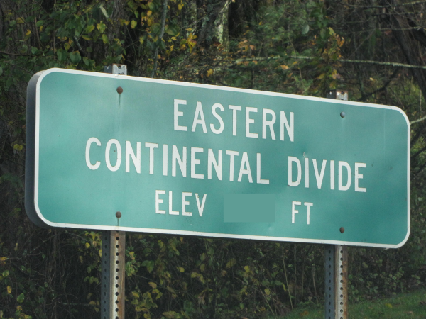
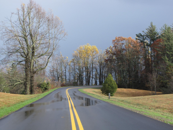 over high summits and along the ridges of the Blue Ridge Mountains in North and South Carolina, The Eastern Continental Divide lies on some of the most spectacular scenery that the Carolinas have to offer.
This is a somewhat unique spot in that this is one of the the few spots where the Continental Divide is marked by a sign along the entire Blue Ridge Parkway(BRP).
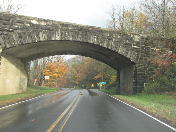
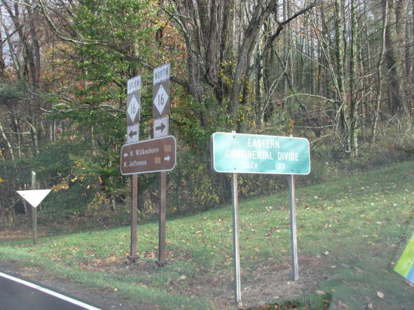 This is an easy EarthCache to get to...just take the exit off the Blue Ridge Parkway near Mile Post 261 where Hwy 16 crosses under. Please be mindful of traffic.
I have rated the terrain a '1', and the cache is completely do-able from a wheelchair, however, while the terrain here is flat, there is some grass, and the traffic could be a problem. It IS possible to do this cache from your vehicle.
A continental divide, sometimes called the backbone of a continent, is a topographic feature, a line of elevated terrain which forms a border between separate drainage basins or watersheds.
The term Continental Divide refers to a particular type of drainage divide. A drainage divide/continental divide is the boundary of a drainage basin. It is the geological boundary that physically separates the drainage of one drainage basin from that of another drainage basin.
Precipitation on one side of a divide will drain into one basin and precipitation on the other side will drain into another basin.
This results in streams, rivers and waterways which make up a drainage basin flowing toward the opposite sides of a continent, depending on which side of the divide they are on. It may be easier to think of a continental divide as being like the peak of a ridge line. It is at this ridge line that we theoreticaly could pour a glass of water off one side of the ridge and it would end up in one watershed and a glass of water poured off the other side would end up in a completely different watershed.
A Continental Divide is found on each of the continents except for Antarctica which has no Continental Divide.
How exactly did these continental divides come to be?
A Continental Divide results over millions of years as the earth's crust folds, forming mountain ranges and their ridges and peaks, which then erode.
We may picture the divide as a line on a map.(see photo). The position and number of divides, including The Great Divide, is strongly affected by climatic and tectonic forces (forces within the earth that cause movements of the earth’s crust), which raise mountains and alter drainage patterns. Surprisingly, the Continental divide is not static. It is dynamic and changes in accordance with these tectonic forces as well as isostatic forces (equilibrium in the earth’s crust where the forces that tend to elevate landmasses balance the forces tending to depress landmasses). Climatic forces also have an impact in that they may alter drainage patterns and growth or loss of continental glaciers.
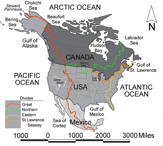
The United States has 4 Continental Divides:
1) The Great Divide which is also known as the Continental Divide
2) The Northern Divide or Laurentian Divide
3) The St. Lawrence Seaway Divide
4) The Eastern Continental Divide
The Continental Divide in North America is the line that divides the flow of water between the Pacific Ocean and Atlantic Ocean. Rain or snow that drains on the east side of the Continental Divide flows toward the Atlantic Ocean while precipitation on the west side drains and flows toward the Pacific Ocean. (However, some rivers empty into the desert and don't end up in the oceans). The continental divide runs north to south from the Seward Peninsula in Alaska, through British Columbia in northwestern Canada, through Montana, Wyoming and Colorado along the crest of the Rocky Mountains to New Mexico. Then, it follows the crest of Mexico's Sierra Madre Occidental, and finally extends to the tip of South America following the crest of the Andes. The Great Divide is the only one of the world’s conitnental divides that divide the river systems of two continents.
The Eastern Continental Divide, (the one we are interested in here), is the name given to the principal, and largely mountainous, hydrological divide of the Eastern US that separates the drainage basins that either drain to the west, toward the Gulf of Mexico, or to the east, toward the Atlantic Ocean.
This Divide runs from a triple point called the Triple Divide at N 41 50’47” W 077 50’ 17” near the town of Gold in Potter County in northern Pennsylvania south of Wellsville (village), New York. It runs down the Appalachian Mountains through Maryland, West Virginia, Virginia, North Carolina, along the northwestern border of South Carolina, and through Georgia and the city of Atlanta, and down through Florida ending at the southern tip of Florida.
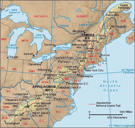
Due to the fact that the Eastern Continental Divide is aligned in this generally southwest to northeast direction following the course of the Appalachian Mountains,
 we find that on the north and west sides of the divide, water flows to the Gulf of Mexico via the watershed claimed by the Tennessee Valley Authority. To the east and south of the divide, water flows to the Atlantic Ocean.
A look at rocks exposed in today's Appalachian mountains reveals elongated belts of folded and thrust faulted marine sedimentary rocks, volcanic rocks and slivers of ancient ocean floor, which provides strong evidence that these rocks were deformed during plate collision. The birth of the Appalachian ranges was some 300 million years ago.
**************************************************************************** 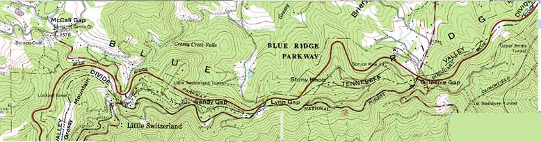 The ECD loosely follows the Parkway and near Little Switzerland crosses the Parkway 7 times in just 10 miles!
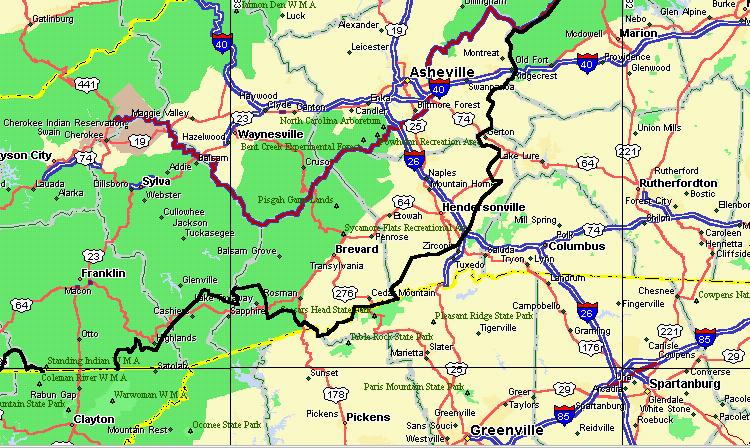 This map shows where the ECD (shown as a black line on the map) intersects the Blue Ridge Parkway (purple) near Mt. Mitchell.
The ECD in North Carolina is clearly mapped, since it is the TVA Boundary that defines all water that drains into the Tennessee River basin. (All the immediate area NW of the ECD  here is part of the TVA watershed). The Divide then follows the Blue Ridge Parkway eastward for about 40 miles to the Linville Falls area, and crosses a few other spots further north.
(Here is a photo of another ECD crossing the BRP at Buck Creek Gap and Highway 80). →
At the location of the cache is the divide. We find it creates a natural boundary line forming the border between two drainage basins. The precipitation falling on one side of this boundary line eventually travels to one side of the continent and precipitation falling on the other side eventually travels to the other side of the continent, provided the water is not evaporated or re-diverted in any way.
Commonly it is said that precipitation falling on opposite sides of the divide always travels to two different oceans. However, snow that melts or water that falls may actually evaporate or be used by vegetation after the water enters into the soil. When this happens, the precipitation may not actually make it to an ocean unless it again falls as precipitation. Also, lot of the precipitation flows to deep underlying aquifers of groundwater. Sometimes, because the divides are underground in the aquifers, they do not match exactly to the above ground Continental Divide. Then the water that falls on one side of the topographical Continental Divide may actually infiltrate the groundwater, travel within the underground aquifer and then be redistributed on the other side of the divide.
Even though it is not possible us to positively determine the destiny of each and every single drop of water that falls along the Continental Divide, we can be fairly certain that for the most part the precipitation falling east of the divide will ultimately reach one body of water and the water falling west of the divide will ultimately reach a separate body of water.
Thank you for visiting the Eastern Continental Divide and learning a bit about earth science.
Happy Caching and Enjoy your travels!
I request that you email your answer(s) to me on the same day that you log your “found it” log. (This does not have to be the day you visit, just the day you log the find on the computer.) I also request that you do not log a “found it” log unless you have actually visited the site of the earthcache and sent the answer(s) to me. The only person who really benefits from your visit is YOU.
I hope you enjoy your visit to this Blue Ridge Parkway Eastern Continental Divide.
Permission granted for this EarthCache by The National Park Service.
I would like to thank the National Park Service (The Blue Ridge Parkway) U.S. Department of the Interior, for approval of this EarthCache. Always obtain approval from land managers before developing an EarthCache.
Remember: All plants and animals on the parkway are protected. You are allowed to gather edible fruits, nuts, & berries for your personal consumption only. Please stay on established trails.
Please note that rock and mineral collecting is NOT PERMITTED along the parkway.
------------------------------------------------------------------------
| I have proudly earned the Geological Society of America's highest level: |
 |
------------------------------------------------------------------------
FTF HONORS GO TO ...litngbug!!!