LOOKING GLASS ROCK is a monolithic piece of exposed granite rising from the valley floor in the midst of the Pisgah National Forest in the Appalachian Mountains of Western North Carolina.

For those caching paperless, I'm including the logging requirements here as well as at the page bottom.
TO LOG THIS EARTHCACHE:
From you observations at the cache location and the interpretive sign located there,
SEND ME Your Best Answer or Educated Guess to at least ONE of the Following Questions, OR , if you take a PHOTO (of YOU, if you wish) ( & YOUR GPS if you can) AT THE CACHE COORDS, THAT CAN COUNT AS YOUR PROOF OF VISIT:
1) Standing at the coordinates, look at the rocks around and behind you.
In your opinion, Are they made of the same material as Looking Glass Rock?. 1) = _____.
2) Why do you think Looking Glass Rock stands exposed above the surrounding rock?.
2) = _____________________________.
3) What kind of activity made Looking Glass Rock form? (Read the information presented on the interpretive sign to help you formulate your answer).
(3)= __ __ __ __ __ __ __ __ __ __ __ - __ __ __ __ __ __ __ __ - __ __ __ __ __ __ __ __.
Irregular in shape and encompassing approximately 60 square kilometers (km),
LOOKING GLASS ROCK is ONE of the LARGEST MASSES of GRANITE in the Eastern United States!
It gets its name from the shimmering effects of sunlight reflecting brilliantly from its granite surface when it is wet or covered with ice.
Our viewpoint is from the VIEW LOOKING GLASS ROCK Overlook, located at Mile Post 417 along The Blue Ridge Parkway looking East.  The Blue Ridge Parkway is the most visited unit in The National Park Service.. The Parkway extends more than 469 miles along the crest of the southern Appalachians and provides a link between the Shenandoah and Great Smoky Mountains National Parks .
The Blue Ridge is a deeply dissected mountainous area of numerous steep mountain ridges, basins and trench valleys that intersect at all angles and give the area its rugged mountain character. The Blue Ridge contains many of the highest elevations and some of the most rugged topography in the Appalachian Mountain system of eastern North America. While Mt. Mitchell is the highest mountain east of the Mississippi, it technically is part of the Black Mountains, rather than the Blue Ridge. The Park Service often gets the question of why Grandfather Mountain is billed as the highest point in the Blue Ridge when Mt. MItchell is the highest point in the eastern U.S. The explanation is that the Black Mountains, the Balsams, Plott Balsams, the Blue Ridge and the Craggies are all "ranges that run rather like rungs on the larger Appalachian ladder". The North Carolina portion of the Blue Ridge is about 200 miles long and ranges from 15 to 55 miles wide. It contains an area of about 6,000 square miles, or about 10 percent of the area of the state.
 Looking Glass Rock is a popular hiking and rock climbing destination. It is located about 5.5 miles(mi.) (9 km) Northwest of Brevard and 25 mi. (40 km) Southwest of Asheville. Trails from Forest Service Road 475 and 475B lead to the top of the mountain. It is a moderate/strenuous trail climbing 1700 ft over 3.1 miles to its peak where panoramic views can be seen of the Blue Ridge Parkway and surrounding mountains of Transylvania County. If you decide to try your hand at hiking this trail, you can tell your friends you've scaled a granitic pluton.
ROCKS CAN TELL A STORY:
The history recorded by humans spans only the past several thousand years on a planet that is 4½ Billion years old. In the course of a person’s lifetime, we see little or no change in the physical features of our planet. The mountains appear to be in the same place and seem just as high. The oceans have the same shores. Rivers follow much the same courses. If earliest man could be brought to our time, the only changes he might notice are that the deltas of some rivers have grown, and some new volcanoes have erupted. The mountains and rivers would appear much the same.
Although we know very little of earliest time, the history of the last billion years is well recorded in the rocks, much like pages in a book. Geologists read these pages with careful research and painstaking observations worldwide. The record is not one of permanence and stability, but one of continual change. On a scale of millions of years, continents and oceans form and disappear, change in shape, and move. Mountains rise out of the sea and later wear down to their roots.
When you view Looking Glass Rock from the Blue Ridge Parkway, it looks like a great stone dome...which is what it is.
Looking Glass Rock itself is a pluton, or an igneous intrusion. Speaking geologically for just a moment, a pluton is a big ball of molten magma that, if it had made it to the surface, would have become the more popularly known 'volcano.' However, the magma (which, again, if it had made it to the surface, could be known by the term 'lava') cooled before it made it to the surface, or erupted. So this big ball of granitic rock lay under the surface of the Blue Ridge mountains in their early formation. As time and weather slowly wore down our mountains (mostly gneiss), this ball of stone became exposed.
More about this in a moment.
PLUTON FORMATION →
HOW DID THE BLUE RIDGE MOUNTAINS COME TO BE?
A Change in Direction - Continental Collision.
About 470 million years ago, the motion of the crustal plates changed, and the continents began to move toward each other. Due to PLATE TECTONIC FORCE continental plates moved closer together, fragments of oceanic crust, islands, and other continental masses 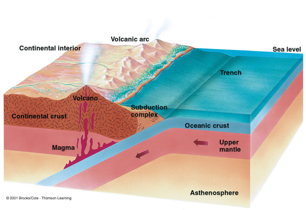 collided with the eastern margin of ancestral North America. About 300-400 million years ago, the continents that were ancestral to North America and Africa collided, causing a forcing down, or (SUBDUCTION), of the Oceanic Crust underneath the North American Conitnent. This resulted in tremendous friction-generated heat in excess of 2000 degrees F which melted the surrounding rock 9 to 15 miles below the surface.This IGNEOUS molten rock was generated under intense pressure. Huge masses of rocks were pushed westward along the margin of North America and piled up to form the mountains that we now know as the Appalachians. This caused some earlier sedimentary rocks to melt due to great pressures within the earth, forming large magma bodies which solidified into rocks (here granite) that were much harder than later rocks which overlay the magma.
As touched on above, as these blocks of continental crust rode across one another, some rocks became so hot that they melted. Molten rock at the Earth's surface erupts to form either volcanoes or quiet lava flows. When molten rock remains deep below ground, it cools and crystallizes to form bodies of rock that called igneous plutons. These Plutons are composed of granite and similar rocks, and are scattered throughout the Southern Appalachians like plums in a pudding. Some plutons are now exposed at the land surface due to erosion of the overlying rock; they weather to form unusual, smooth-sided domes like Looking Glass Rock.
**********************************************************************
More GEOLOGY of LOOKING GLASS ROCK and some DEFINITIONS:
A Pluton is defined as a body of rock formed from magma (molten rock) migrating and solidifying deep in the subsurface, creating an igneous rock.
Magma: - Molten matter within the Earth’s crust, from which igneous rocks form by cooling.
Igneous rocks (from the Greek word for fire) form when magma crystallizes and solidifies. The melting originates deep within the Earth near active plate boundaries or hot spots, then rises toward the surface.
Igneous rocks are divided into two groups, intrusive or extrusive, depending upon where the molten rock solidifies. Looking Glass Rock is an intrusive igneous rock.
Intrusive, or plutonic igneous rock forms when magma is trapped deep inside the Earth. Great globs of molten rock rise toward the surface. Some of the magma may feed volcanoes on the Earth's surface, but most remains trapped below, where it cools very slowly over many thousands or millions of years until it solidifies. Slow cooling means the individual mineral grains have a very long time to grow, so they grow to a relatively large size. Intrusive rocks have a coarse grained textureand typically display visible mineral grains that are fairly easy to recognize with a little training.
Extrusive igneous rock is formed from the solidification of lava on or above the surface. Rapid cooling from exposure to air or water results in rapid crystallization of their component minerals, normally creating a fine grained texture as opposed to intrusive igneous rock which has a coarser texture.
Granite: Granite is a coarse-grained igneous rock that is composed of four minerals. These minerals are quartz, feldspar, mica, and usually hornblende. Granite forms as magma cools far under the earth's surface. Because it hardens deep underground it cools very slowly. This allows crystals of the four minerals to grow large enough to be easily seen by the naked eye.
Note that the word "granite" is used fairly liberally. Many rocks called "granite" are technically something different. The word "granitoid" or "granitic" implies felsic to intermediate intrusive rocks of many varieties, including granite.
Granitic: A general term for intrusive igneous rocks that look similar to granite but may range in composition from quartz-diorite to granite. All granitic rocks are light colored; feldspar and quartz are visible in hand specimen.
Quartz: A very common rock-forming mineral consisting of silicon dioxide.
Feldspar: A group of widespread aluminum-silicate minerals containing oxides of sodium, calcium, or potassium, which constitute 60 percent of the rocks of the Earth’s crust. Feldspar minerals occur as components of most rock types, especially igneous and metamorphic rocks.
Granodiorite: A type of plutonic igneous rock in which two or more varieties of feldspar are accompanied by quartz and smaller amounts of dark minerals such as biotite mica and hornblende.
Hornblende: The most common mineral of the amphibole group, a complex hydrous aluminum silicate in which calcium, sodium, iron, and magnesium are present in varying amounts; commonly black, dark-green, or brown and occurring in distinct long, slender crystals or in columnar, fibrous or granular forms. It is a primary constituent of many felsic and intermediate igneous rocks and less commonly of mafic igneous rocks.
Mafic igneous rocks: Ones composed chiefly of dark minerals, such as hornblende and iron-and magnesium-rich biotite mica.
Mica: A group of hydrous aluminum-rich silicate mineral, all of which have perfect basal cleavage that allow them to be peeled apart in thin layers.
Minerals: Naturally occurring inorganic chemical elements or compounds having an orderly internal atomic structure and characteristic chemical composition. Most minerals have a definite crystal form and physical properties.
******************************************************************
Again, TO LOG THIS EARTHCACHE:
From you observations at the cache location and the interpretive sign located there,
SEND ME Your Best Answer or Educated Guess to at least ONE of the Following Questions:
1) Standing at the coordinates, look at the rocks around and behind you.
In your opinion, Are they made of the same material as Looking Glass Rock?. 1) = _____.
2) Why do you think Looking Glass Rock stands exposed above the surrounding rock?.
2) = _____________________________.
3) What kind of activity made Looking Glass Rock form? (Read the information presented on the interpretive sign to help you formulate your answer).
(3)= __ __ __ __ __ __ __ __ __ __ __ - __ __ __ __ __ __ __ __ - __ __ __ __ __ __ __ __.
While Not Required, A Photo of you, (if you wish) (and your GPS if possible) at the cache is Always Appreciated, AND, CAN COUNT AS YOUR PROOF OF VISIT in place of answers to the questions.
Thank you for visiting the Looking Glass Rock EarthCache and learning a bit about earth science.
Happy Caching and Enjoy your travels!
I request that you send your answers to me on the same day that you log your “found it” log. (This does not have to be the day you visit, just the day you log the find on the computer.) I also request that you do not log a “found it” log unless you have actually visited the site of the earthcache and sent the answers to me. The only person who really benefits from your visit is YOU.
I hope you enjoy your visit to this Blue Ridge Parkway EarthCache.
Permission for this cache has been granted by The National Park Service.
FTF HONORS GO TO ...duos perquisitor!!!
I would like to thank the National Park Service (The Blue Ridge Parkway) UnitedStates Department of the Interior, for their approval of this EarthCache. Remember: All EarthCache sites developed must have prior approval of the landowners before submission.
NOTE: All plants and animals on the parkway are protected. You are allowed to gather edible fruits, nuts, & berries for your personal consumption only. Please stay on established trails.
Please note that rock and mineral collecting is NOT PERMITTED along the parkway.
I used the publication "A Geologic Adventure Along The Blue Ridge Parkway in North Carolina" (Bulletin 98, North Carolina Geological Survey Section, Department of Environment and Natural Resources) for much of the information included here, after calling and obtaining permission to do so from Mike Medina of The North Carolina Geological Survey.
As well, I utilized the USGS publication "Birth of the Mountains, The Geologic Story of the Southern Appalachian Mountains", United States Department of the Interior, United States Geological Survey.
------------------------------------------------------------------------
| I have proudly earned the Geological Society of America's highest level: |
 |
------------------------------------------------------------------------