Background
This earthcache will guide you to some miniature folds (folds
you can wrap your arms around or close anyway) as well as give you
more information on what caused the folding in this area. A fold is
a structural feature that is formed when planar surfaces are bent
or curved (Van Der Pluijm and Marshak, 2004). In this case, the
planar surface is the rock itself. Folds have very similar
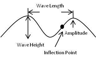
terminology when compared to wave terminology from physics. A fold
has a wavelength, an amplitude, inflection point, crest, trough,
and wave height. As well, folds have what is called a hinge line,
and an axial surface. These terms are defined below.
Remember these definitions because you will have to answer
questions relating to them below.
Crest: The highest point of a fold.
Trough: The lowest point of a fold.
Wavelength: The distance between two adjacent crests or troughs of
a fold.
Wave height: The vertical distance between a crest and trough of a
fold.
Inflection point: The point on a fold where the curvature changes
from convex to concave.
Amplitude: The distance from the crest to the inflection point of a
fold.
Hinge line: The line of greatest curvature in a fold.
Axial surface: The surface containing the hinge lines of individual
folds stacked on top of each other vertically.
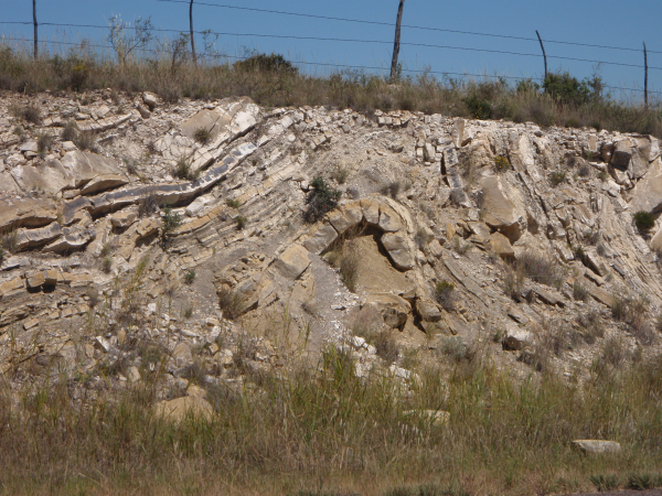
 All of the folding that you see is the direct result of what is
called the Ouachita Orogeny which extends for about 1300 miles from
Mississippi to this region of West Texas. About 80% of this orogeny
is buried in the subsurface. The two major areas exposed are the
Ouachita Mountains in Oklahoma and Arkansas and the Marathon region
of West Texas (Wicander and Monroe, 2000). This area is very
important because geologists are able to examine the rocks and
folds and determine why they formed in the way they did and how
this area has developed into what you see today.
All of the folding that you see is the direct result of what is
called the Ouachita Orogeny which extends for about 1300 miles from
Mississippi to this region of West Texas. About 80% of this orogeny
is buried in the subsurface. The two major areas exposed are the
Ouachita Mountains in Oklahoma and Arkansas and the Marathon region
of West Texas (Wicander and Monroe, 2000). This area is very
important because geologists are able to examine the rocks and
folds and determine why they formed in the way they did and how
this area has developed into what you see today.
Tasks
Go to Waypoint 1 and answer the following questions:
1. What is the name of the continent that collided with North
America to form this mountain building event?
2. Who put together the fold sequence diagram?
Go to Waypoint 2 and answer the following questions:
1. Estimate the amplitude of one of the folds at the posted
coordinates. (Don’t forget the definition!)
2. Estimate the wavelength of the fold from question one.
3. Is this fold cylindrical or non-cylindrical? (Is the hinge line
vertical or near vertical? If so, then it is cylindrical, if not it
is non-cylindrical).
4. Take an optional picture with you and the fold in it.
References
Hickman, R. G., Varga, R. J., and Altany, R. M., 2009.
Structural style of the Marathon thrust belt, West Texas. Journal
of Structural Geology, 31, 900-909.
Wicander, R., and Monroe, J. S., 2000. Historical Geology:
Evolution of Earth and Life Through Time 3rd Edition.
Van Der Pluijm, B. A., and Marshak S., 2004. Earth Structure 2nd
Edition.