The published coordinates will take you to the entrance gate of the Island but to get there you will have to take a ferry from Cape Town. The Ferry Terminal is situated at Nelson Mandela Gateway, at the V&A Waterfront (DEPART, S33° 54.395 E018° 25.345). Ferries depart at 9am, 11am, 1pm and 3pm, weather permitting. It is a good idea to buy your tickets beforehand as Robben Island is a very popular destination, especially during the tourist season.
For updated ticket prices and schedules go to the Robben Island Museum website.
What makes Robben Island so special?
Robben Island lies on the Western Coast of Africa a short distance from Cape Town, across the icy, shark-ridden waters of the Atlantic. Windswept and waterless, the 518ha Island has long been a place of banishment and despair. Infamous as a Maximum Security Prison from the 1960s to the 1990s, its most famous prisoner was Nelson Mandela. Today, the Island is a National Monument and World Heritage site, celebrating the triumph of the human spirit over the shackles of the past.
Geology of Robben Island
 Geological map of the island showing the basement metasediments of the Neoproterozoic Malmesbury Group (brown) exposed around the shore, while the flat interior of the island is covered by Pleistocene calcretised dune sands (coastal limestone - yellow). Image sourced from UCT Department of Geological Sciences website.
Robben Island is roughly oval in shape, 3.3 km long north-south, and 1.9 km wide, with an area of 5.07 km². The Island is actually the summit of an ancient, now submerged mountain, linked by an undersea saddle to the Blouberg. Below is an image (left) that shows what the coastline looked like when the sea level was 125m lower at the time of maximum ice build-up during cold periods – the most recent being 20 000 years ago. Those days Robben Island was a hill on a coastal plain with the sea a few kilometers west of the island. The image on the right show the coastline approximately 1.5 million years ago when the sea level was 25m higher than now. Both images also indicate the current South African coastline for reference. The position of Robben Island is visible in the top left corner.

 Image sourced from Wikipedia website.
The island is flat with the highest point (Minto Hill) only 24 metres above sea-level. The climate is Mediterranean, as in nearby Cape Town, but the Island experiences stronger winds and comparative extremes in temperature. The low, flat profile is the product of wave action during a higher sea level stand. The island's lower strata consists of Precambrian metamorphic rocks belonging to the Malmesbury Group, forming a somewhat inhospitable coastline.
"The late-Precambrian age Malmesbury group is the oldest rock formation in the area, consisting of alternating layers of dark grey fine-grained greywacke, sandstone and slate, seen along the rocky Sea Point and Bloubergstrand shorelines, and from the Strand to Gordon's Bay. These sediments were originally deposited on an ancient continental slope by submarine slumping and turbidity currents.
Most of the exposed shoreline Malmesbury rocks are steeply dipped, and weathered to form sharp edged ridges where more resistant layers stand out among the softer strata. The rocks are generally dark in colour where fresh rock has been exposed by erosion, and may be finely laminated" - Wikipedia
Above the Precambrian Malmesbury slate lies a thick limestone and calcrete deposit covered by windblown sands and shell fragments. It is in this layer that you will find the now famous Limestone quarry where political prisoners like Nelson Mandela had to work from between 1965 and 1994.
The quarrying of the island's blue slate and lime was one of the first industries of the colonial Cape and it commenced shortly after Jan van Riebeeck established the first way station in 1652. The quarry originally used is now known as Van Riebeeck's Quarry. It is unlikely that you will be able to explore this quarry but it is visible (near Alpha One) from the road. The hard greywacke sandstone of the Malmesbury Group quarried here provided excellent building material for early colonial buildings, such as the Cape Town Castle.
 Schematic cross section through Roben Island showing its rock basement (Malmesbury Group metasediments) and the thin veneer of Quaternary dunes (from a poster by De Beers Marine). Image sourced from UCT Department of Geological Sciences website.
Logging Requirements
EarthCaches are a special type of Virtual Cache that are meant to be educational. Therefore, to log, you must demonstrate that you learned something from the site and experience. The bus tour around Robben Island focuses mainly on the old prison compounds, formerly occupied by anti-apartheid political prisoners. You might find it difficult to go and explore the island’s geological features on your own.
To log this EarthCache you must identify the Precambrian Malmesbury Slate, determine the thickness of the limestone layer which rests on top of it and estimate the altitude at the Limestone quarry. The bus tour will take you to the Limestone quarry and Alpha One so it will be possible to perform the following tasks.
1.) At Alpha One (ALPHA1, S33 49.064 E018 22.781) – the rocks that you see along the shore is of the Precambrian Malmesbury Group. Give a brief description of the rocks. Why do you think so many ships (at least 31 within one nautical miles around the island) were wrecked off Robben Island?
OPTIONAL - Take a photograph showing your navigation device with the exposed rocks and Table Mountain in the background - similar to this image:

2.) At the Limestone quarry (LIMEST, S33 48.299 E018 22.446) – estimate how thick the limestone deposit is. It is possible that you won’t be able to walk into the quarry so you might have to do this from the bus - use the cave opening for scale.
3.) To determine what the altitude is at the top of the Limestone Quarry do the following:
When you are walking to (or from) the ferry stop at waypoint SIGNPO (S33 47.939 E018 22.535). You will see a signpost indicating the direction to Prison, Kramat, Visitors Block and XXXXXXX XX?X. Assuming A=1, B=2 etc. what is the value of the second last letter? The answer = the altitude of the floor of the Limestone quarry. Now just add the depth of the quarry to get the height above sea level.
4.) OPTIONAL - Remember to also visit the Castle in Cape Town to see how the rock from Van Riebeeck Quarry was used in its construction.
Please send answers to sa.urbancampers@gmail.com
You are welcome to log your visit before you get confirmation from us, however, logs without emails will be deleted.
Robben Island - Brief history and interesting facts
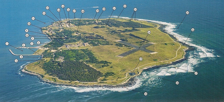 Image sourced from "Robben Island", ISBN 1-920380-04-3
| 1. Murray's Bay Harbour |
11. Faure Jetty |
21. WWII Batteries |
| 2. Main Penguin Nesting area |
12. Garrison Church |
22. Funjong shipwreck (1975) |
| 3. Kramat |
13. Commissioner's House |
23. WWII Searchlights |
| 4. Old Prison Buildings |
14. School |
24. Aircraft landing strip |
| 5. Female leper quarters |
15. Irish Cemetery |
25. Long Bay |
| 6. Maximum Security Prison |
16. Barracks |
26. Bath of Bethesda |
| 7. Leper graveyard |
17. Alpha One |
27. Han Cheng shipwreck (1998) |
| 8. Robert Sobukwe Complex |
18. Limestone Quarry |
28. Rangatira Bay |
| 9. Church of The Good Shepherd |
19. Van Riebeeck's Quarry |
29. Blue Stone Quarry |
| 10. Medium B Prison |
20. Lighthouse on Minto Hill |
30. Sea Challenger shipwreck (1998) |
Since the end of the 17th century, Robben Island has been used to isolate people — mainly political prisoners. The Dutch settlers were the first to use Robben Island as a prison. Its first prisoner was probably Harry die Strandloper in the mid-17th century. Amongst its early permanent inhabitants were political leaders from various Dutch colonies, including Indonesia. After a failed uprising at Grahamstown in 1819, the fifth of the Xhosa Wars, the British colonial government sentenced African leader Makanda Nxele to life imprisonment on the island. He drowned on the shores of Table Bay after escaping the prison.
The island was also used as a leper colony and animal quarantine station. Starting in 1845 lepers from the Hemel-en-Aarde (Heaven and Earth) leper colony near Caledon were moved to Robben Island. Initially this was done on a voluntary basis and the lepers were free to leave the island if they so wished. In April 1891, the cornerstones for 11 new buildings to house lepers were laid. After the introduction of the Leprosy Repression Act in May 1892 admission was no longer voluntary and the movement of the lepers was restricted. Prior to 1892, an average of about 25 lepers a year were admitted to Robben Island, but in 1892 that number rose to 338, and in 1893 a further 250 were admitted.
During the Second World War, the island was fortified and guns were installed as part of the defences of Cape Town. During this time it was also used as a prison. It is of particular note as it was here that future President of South Africa and Nobel Laureate Nelson Mandela and future South African President Kgalema Motlanthe, alongside many other political prisoners, spent decades imprisoned during the apartheid era.
The Moturu Kramat, a sacred site for Muslim pilgrimage on Robben Island, was built in 1969 to commemorate Sayed Abdurahman Moturu, the Prince of Madura. Moturu, one of Cape Town's first Imams, was exiled to the island in the mid-1740s and died there in 1754. Muslim political prisoners would pay homage at the shrine before leaving the island.
Jan van Riebeeck first set a navigation aid atop Fire Hill (now Minto Hil,), the highest point on the island. Huge bonfires were lit at night to warn VOC ships of the rocks that surround the island. The current Robben Island lighthouse, built on Minto Hill in 1864, is 18 metres (59 ft) high and was converted to electricity in 1938. It is the only South African lighthouse to utilise a flashing light instead of a revolving light. Its light is visible for 24 nautical miles.
Reference
On Route in South Africa by BPJ Erasmus ISBN: 1 868 42025 6
Robben Island by C Smith ISBN: 978 1 86872 062 0
Robben Island out of despair, hope ISBN: 1 920380 04 3
Geological Journeys by N Norman & G Whitfield ISBN: 978 1 77007 062 2
The Geology of Robben Island – University of Cape Town Department of Geological Sciences website
Sedimentology, geochemistry and tectonic setting of the Neoproterozoic Malmesbury Group (Tygerberg Terrane) and its relation to neighbouring terranes, Saldania Fold Belt, South Africa by W Buggisch, Erlangen, G Kleinschmidt, Frankfurt am Main, and S Krumm, Erlangen.