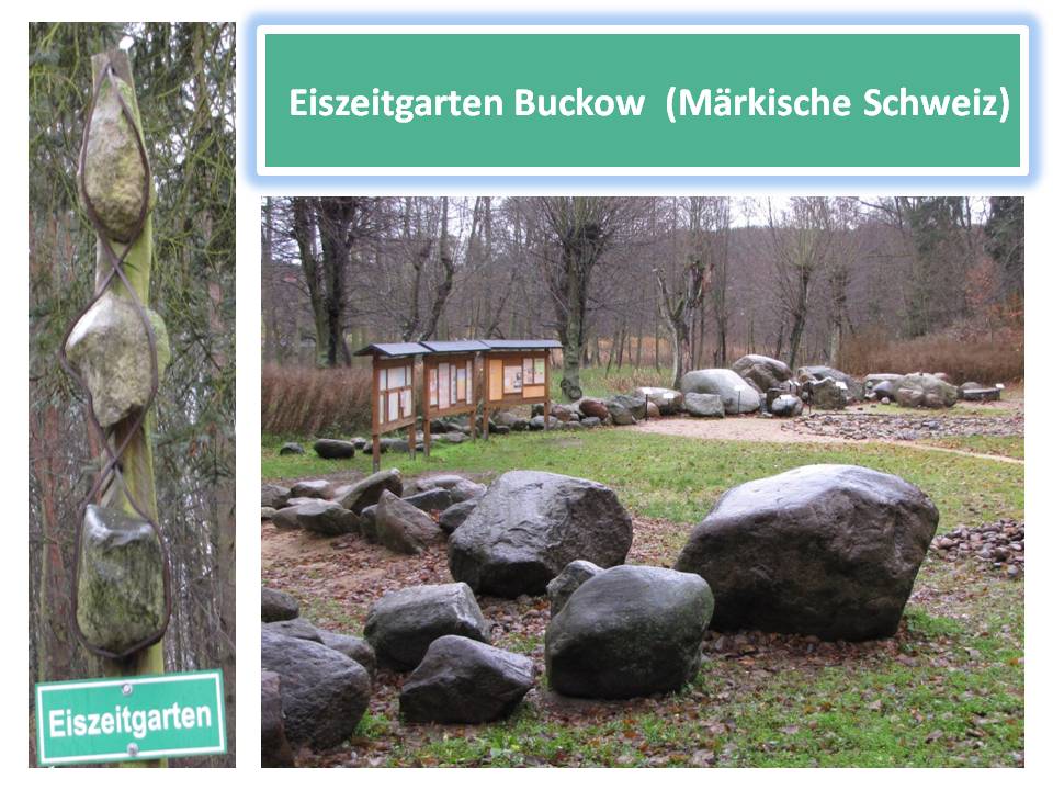
Buckow – die Perle der Märkischen Schweiz- liegt in einer von verschiedenen Eiszeiten geprägten Region. Riesige Eismassen, die über Buckow eine Dicke von bis zu einigen hundert Metern hatten, und die nachfolgenden Schmelzwasser gaben der heutigen Landschaft ihre Form: Höhenrücken und Hochflächen, Seen, Täler und Schluchten sowie Sandflächen und Dünen, Geröllpackungen und mit Steinen gesprenkelte Ackerflächen. Der Eiszeitgarten Buckow macht modellhaft die gestaltende Kraft des Eises sichtbar.
Eiszeiten sind Zeitabschnitte, in denen Eis große Teile der Erdoberfläche bedeckte. Sie sind das Ergebnis von Abkühlungen infolge der Abnahme der Sonneneinstrahlung auf der Erd-oberfläche. Das Eis kam von Nordeuropa, wo es gebildet wurde, und es dehnte sich in alle Richtungen aus, auch nach Norddeutschland. Von 400 000 bis 14 000 Jahren vor heute stieß das Inlandeis mehrfach in die Gegend um Buckow vor: es gab drei Eiszeiten, die nach den Flüssen benannt wurden, bis zu denen das Eis maximal vorstieß (Elster, Saale, und Weichsel). Für Buckow und Umgebung ist die jüngste Eiszeit von besonderer Bedeutung: man konnte drei Eisvorstöße nachweisen, von denen zwei die Gegend um Buckow überfuhren bzw. erreichten und die gegenwärtige Landschaft prägten. Zwischen den Vorstößen gab es immer wieder Warmzeiten und kältere Zeiten ohne Eis.
Transport von Steinen durch das Eis: Von Skandinavien und dem Ostseeraum hat sich das mehrere hundert Meter dicke Eis auf seinem 100 bis über 1000 km langem Weg bis in die Buckower Gegend gedrückt und geschoben. Dabei bilden sich im Eis Scherflächen, an denen Eisblätter oder –platten von hinten über bereits vorgestoßenes Eis geschoben wurden. Das vom Untergrund aufgenommene Gesteinsmaterial (eine Mischung von metergroßen Blöcken bis mikrometer-großen Tonpartikeln) wird so in das Eis hinein und später an die Eisoberflä-che geschoben und reist bis dorthin, wo das Eis schließlich schmilzt.
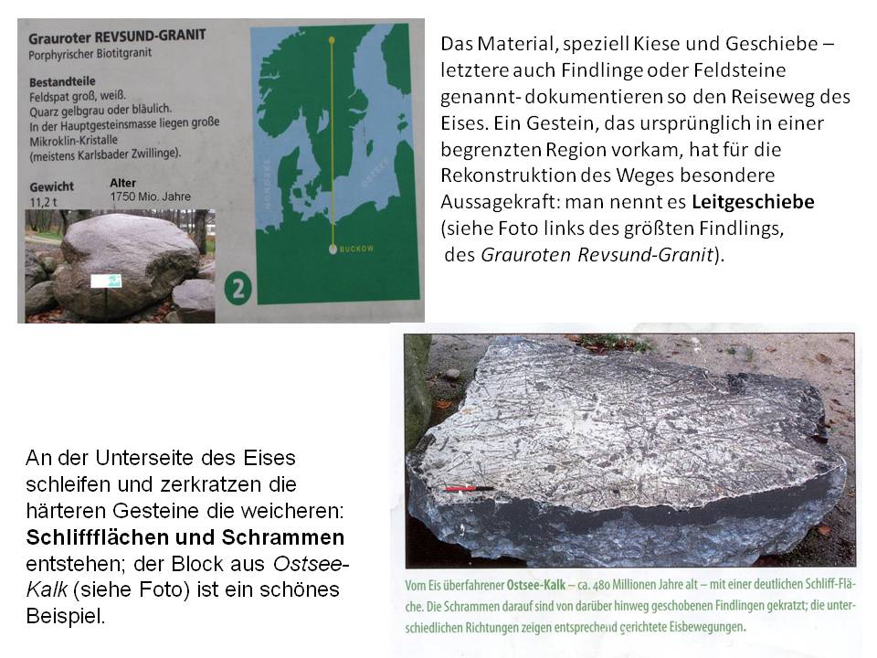
Auch der Wind wirkt, indem er durch Aufnahme von Sand wie ein Sandstrahler die Gesteine „geschliffen“ hat. Es entstanden charakteristische –für die Windrichtung typische stumpf-winklige Kanten- die Windkanter.
An vielen Gesteinen im Eiszeitgarten sieht man die beschriebenen Spuren von Eis und/oder Wind. Mehrere großformatige Hinweistafeln geben einen Überblick über alle Facetten der Eiszeiten.
LITERATUR: - Flyer des Kultur- und Tourismusamts Märkische Schweiz, Buckow.
- Infotafeln vor Ort
Um den Earthcache zu loggen mußt Du folgende Aufgaben lösen:
1. Wie kommt es zu niedrigen Temperaturen auf der Erde, die Eiszeiten zur Folge hatten ?
2. Welches waren die beiden Eisvorstöße der jüngsten Eiszeit, die Buckow überfuhren bzw. erreichten?
3. Wie nennt man Gesteine, mit deren Hilfe man den Weg des Eises rekonstruieren kann (es sind Findlinge, aber sie haben einen speziellen Namen!)?
4. Findet den größten Findling im Eiszeitgarten: Aus welchem Gebiet im nördlichen Mittel-schweden stammt er (genaue Bezeichnung!)?
… Den neuen Bestimmungen zu EC`s entsprechend könnt Ihr sofort loggen, danach die Antworten an den Owner senden; er meldet sich dann im Falle von Unstimmigkeiten. …
… Ein Foto von Dir wäre schön – aber ist natürlich optional …
English text
Buckow- the pearl of the Märkische Schweiz (Brandenburg) lies in a region characterized by several ice ages. Huge masses of ice that had to Buckow a thickness of up to several hundred meters, and the subsequent melt-water gave the current landscape its form: ridges and plateaus, lakes, valleys and gorges and sandy plains and dunes, gravel packs and speckled with stones farmland. The Ice Age Garden Buckow makes the creative force of the ice visible.
Ice agesare periods of time in which ice covered large parts of the earth's surface. They are the result of cooling due to the decrease of solar radiation on the Earth's surface. The ice came from northern Europe, where it was formed and stretched in all directions, even to Northern Germany. From 400.000-14.000 years ago today, the ice pushed repeatedly in the area around Buckow: there were three ice ages, which are named after the rivers by which the ice was maximum protruding (Elster, Saale and Weichsel). For Buckow and its environment the most recent ice age was of particular importance. During this youngest ice age three ice advances have been observed, which markedly gave the landscape its present form; two of which reached the area around and/or run over Buckow. Between the advances there have always been warm periods and colder periods without ice.
Transport of stones by the ice: From Scandinavia and the Baltic Sea region, the several hundred meter thick ice on his 100 up to over 1000 km long way has pushed into the area of Buckow. Ice shear surfaces were formed, where ice sheets or plates from the back were pushed over already existing ice. The rock material taken from the substrate material (a mixture of meter-sized blocks to micrometer-sized clay particles) was pushed into the ice and later slid to the ice surface – travelling in this way to locations where the ice finally melts. This way, the material, called gravel and sediment (boulders bedload) (the latter also called boulders or pebbles) document the path of the ice. Thus, a rock that originally occurred in a limited geographic region is particularly significant for the reconstruction of the ice path: therefore, it is called Leitgeschiebe (see photo of the largest boulder, the Gray-Red Revsund Granite).
At underside of the ice the harder rocks drag and scratch the softer ones: ground surfaces and scratches were formed (the block of Baltic-lime is a good example, see photo). The wind also acts by taking up sand and thus acting like a sand-blasting machine, sharpening the rocks. Wind action formed -characteristic for the wind direction- typical blunt-angled edges, so called ventifacts (windkanter).
At many boulders in the Ice Age Garden you can see the described traces of ice and/or wind. Several large info boards in the garden will give you an overview of all facets of the ice ages.
To log this earth cache you must solve the following tasks:
1. What causes low temperatures on the earth that have the effect of ice ages?
2. Which were the two ice advances of the recent (youngest) ice age, which ran over and/or reached Buckow region?
3. How do you call rocks, from which one can reconstruct the path of the ice?
4. Find the largest boulder in the Ice Garden: From which area in the northern central Sweden it came from? (name the exact location!)
… After the visit you can just log, but afterthat you must send the answers to the owner; He will contact you in case of errors.…
... A photo of you would be nice – however it is optional …