
Entstanden ist der Steinsberg, wie auch der Katzenbuckel bei Eberbach, durch die Verschiebung der Afrikanischen Kontinentalscholle nach Norden. Zur Zeit der Wende, zwischen Kreide und Tertiär, entstand hier an einer Schwächezone in der rund 30 km dicken Erdkruste eine bis in den Erdmantel tief greifende Spalte.
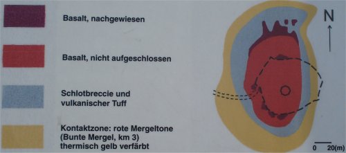
Hier drangen in einer explosiven Phase energiereiche, heiße Gase und Tuffe (vulkanische Aschen) durch das Grund- und Deckgebirge und bildeten mit dem mitgeschleppten und hineinfallenden Nebengestein ein Gas-Tuff-Gesteinsgemisch.
Danach drang in einer effusiven Phase (von lateinisch effusio = das Ausgießen, Verschwendung) flüssiger, glutheißer schwarzgrauer Nephelinbasalt aus der Tiefe des Erdmantels nach.
Der Schlot des Steinsberg-Vulkans hatte einen Durchmesser von ca. 300m. Aus der Bestimmung des Nebengesteins ist anzunehmen, dass die ehemalige Landoberfläche mehr als 300 m höher als heute gelegen hat.
Der Nephelinbasalt ist grauschwarz, besitzt eine mittlere bis feine Körnung und verfügt nur über wenige Einprenglinge. Stellenweise enthält der Basalt sehr hohe Gehalte an Magnetit, wodurch eine Kompassnadel von der magnetischen Nordrichtung abgelenkt werden kann.
Dieses jetzt erkaltete Vulkangestein ist am Fuße der äußeren Burgmauer stellenweise noch zu finden. Durch die hohen Temperaturen der Gase und Basalte von über 1000 Grad Celsius wurde das umgebende unbeeinflusstes Schichtgestein, hier rotbunte Tonmergelsteine, thermisch zu hellgelb angeschmolzen.
Nach dieser sehr kurzzeitigen, vulkanischen Tätigkeit, unterlag der Steinsbergvulkan der immer andauernden Abtragung. Da hier der Basaltkern einen erheblichen härteren Widerstand entgegensetzte, bildet er heute eine markante und höchste Erhebung im Kraichgau.
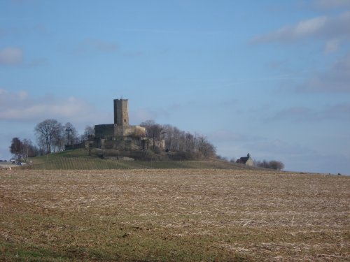
Die auf dem Steinsberg gelegene Burg wurde zwischen 1235 und 1240 aus Keupersandstein erbaut und ist auch wegen seinem, fast 30 m hohen, achteckigen Bergfried, eine imposante Erscheinung und wird deshalb schon in der Frühzeit „Kompass des Kraichgaus“ genannt.
Update 29.06.2021
Die Ursprüngliche Hinweistafel mit Informationen am Parkplatz wurden durch eine neues Schild ohne Geologische Hinweise ersetzt. Daher ändern sich jetzt die Fragen.
Die alten Fragen und Antworten sind:
1. Vor wievielen Jahren entstand die Spalte? - vor etwa 60 Millionen Jahren
2. Ergänze den folgenden Satz: Die rotbunten Tonmergelsteine sind thermisch zu hellgelb ........ (benutze den Ausdruck auf der Infotafel) - gefrittet
Logbedingungen:
Ermittelt die Antworten zu den folgenden Fragen vor Ort. Wenn Ihr möchtet, ladet bitte ein Loggfoto hoch - wir freuen uns darüber! Schickt bitte vor dem Loggen Eure Antworten an meinen GC-Account und loggt direkt online; ich melde mich, falls es Probleme mit den Antworten geben sollte. Logs ohne Antwortmail werden gelöscht.
1. Rechts neben dem Eingangstor in der Ecke befindet sich ein Basalt in der Mauerecke, messe die Höhe und Breite
2. Messe hier die Höhe über NormalNull
3. An der inneren Rinmauer ist auf Augenhöhe ein Schild in Wappenform angebracht mit der Aufschrift "Kegel aus Basalt". Ergänze den Satz: Der Kern ist ein Nephelinbasalt mit einer Ausdehnung von ...m auf ..m

English:
The result is the “Steinsberg”, like the “Katzenbuckel” near Eberbach, according to the displacement of the African continental block north. At the time of turning, between the Cretaceous and Tertiary, was here on a weak zone in the 30 km thick crust a deep cross into the mantle column.
Here broke in an explosive stage energy, hot gases and tuff (volcanic ash) through the base and top with the mountains and formed and entrained host rock falling into a gas-tuff-rock mixture. After that urged an effusive phase (from the Latin effusio = pouring, waste) in cash, red-hot black gray Nephelinbasalt to the depth of the mantle.
The vent of the volcano Steinsberg had a diameter of about 300m. From the determination of the host rock is assumed that the former land surface is located more than 300 m higher than today.
The Nephelinbasalt is gray-black, has a medium to fine grain, and has few Einprenglinge. In places, the basalt contains very high concentrations of magnetite, so that a compass needle to magnetic north can be distracted. This now cooled volcanic rock at the foot of the outer castle wall to find some places still. The high temperatures of the gases and basalts of over 1000 degrees Celsius, the surrounding unbiased layered rock, here Tonmergelsteine red colored, thermally fused to yellow.
After this very short time, volcanic activity, subject to the Steinsberg volcano in the always ongoing erosion. Since opposed the basalt core has a much more stringent resistance, he now forms a striking and highest in the Kraichgau. Situated on the stone mountain fortress was built in 1235-1240 from Keuper sandstone and is called because of its nearly 30 m high, octagonal keep, an imposing figure and is therefore at an early time, "Kompass des Kraichgaus"
Update 06/29/2021 The original sign with information at the parking lot has been replaced by a new sign without geological information. So now the questions are changing. The old questions and answers are:
1. How many years ago did the crevice arise? - about 60 million years ago
2. Complete the following sentence: The red-colored clay marl stones are thermally too light yellow ........ (use the expression on the information board) - fritted
The Quest
You can find the answers to the questions on site. Please prove your visit to this site by sending the answers to my GC.com account, then you may log, I will contact you in case of problems. Logs without an answer-mail will be deleted. If you like, you may upload a logfoto, this is a voluntary rule.
1. To the right of the entrance gate in the corner there is a basalt in the corner of the wall, measure the height and width
2. Measure the height above sea level here
2. A shield in the shape of a coat of arms is attached to the inner wall at eye level with the inscription "Cone made of basalt". Complete the sentence: The core is a nepheline basalt with an extension from ... m to ..m