"The Ground Beneath Your Feet"
Introduction
Throughout the world, karst landscapes vary from rolling hills dotted with sinkholes [as found in portions of the central United States] to jagged hills and pinnacle karst [found in the tropics].
"The development of all karst landforms requires the presence of rock which is capable of being dissolved by surface water or ground water." (1) These rocks that are capable of being dissolved are called "soluble". Karst surfaces are commonly associated with carbonate rocks like limestone and dolomite. Other highly soluble rocks like gypsum and rock salt can be sculpted by the surface and ground water into karst surfaces.
Ten percent of the Earth's surface is composed of karst terrain. Many people on Earth depend on water originating from karst areas. While most abundant in humid regions, karst can be found in temperate, tropical, alpine and even polar environments.
The degree of development of each karst landform will vary from region to region. Karst areas with large drainage systems are likely to have both fluvial (above ground) and karst (below ground) drainage components. The map (figure 1) below shows the different karst systems present in US Geology. The karst system in our area, indicated by the lighter golden color on the map is the "Valley & Ridge, Piedmont and Blue Ridge Aquifer". It is characterized by extensive areas of karst terrain within complex geological structures resulting in varied terrain, as seen below in figure 2.

How karst surfaces form:
Water in the form or rain or snow becomes weakly acidic when it reacts with carbon dioxide in the air and in the soil. This acid is named carbonic acid. The water continues its journey downward, seeping through the soil and cracks in rocks because of gravity. The slightly acidic water will dissolve portions of the rocks along surfaces, joints and fractures, over time, forming caverns and caves, as seen below in figure 2.
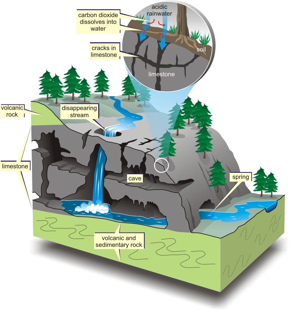
Doline karst is the most widely distributed type of karst surface. This type of landscape is dotted with sinkholes (also called dolines) which can vary in number and size for their distribution. Karst surfaces that are dominated by dolines have several distinct surface features:
- bedrock that was dissolved, leaving behind a bowl shaped depression
- the collapse of shallow caves originally formed by dissolved bedrock
- springs (locations where groundwater emerges at the surface)
- disappearing streams (streams that abruptly end by flowing into the ground) will indicate disrupted surface drainage and the presence of an underground drainage system
- caves (openings large enough to enter)
Why karst surfaces matter:
Knowing where karst surfaces are located can help urban planners and builders make decisions for where it is safe to develop. Prior knowledge can prevent later repairs to buildings that were built on unstable surfaces. Karst springs supply drinking water to millions. Knowledge of the terrain and the movement of underground water systems is critical to maintaining a clean water supply. Pollution of ground water can have disastrous effects in karst terrain.
To Claim a Find on this Earthcache:
Please use the marked trails to find this cache rather than short-cutting or bushwhacking through the woods. Please email the answers to the following questions to the cache owner. Any logs not accompanied by an email containing answers within 48 hours will be deleted. Please use the informational sign at GZ to help you. A picture of you and your GPS at the cache site is not required (per new Earthcache guidelines adopted January 1, 2011).
- Do not go in the sinkhole! From the trail, please estimate it's depth.
- Standing atop a karst surface can be compared to standing atop _____? Explain this comparison.
- Sinkholes can form 2 ways. One was detailed in this write up. What is the other explained on the sign?
- Living in karst areas carries certain responsibilities. Please suggest 3 actions that you personally can do to protect the local water quality.
Sources
(1) Karst Topography: Computer animations and paper model by Tau Rho Alpha, John P. Galloway, and John C. Tinsley III, U.S. Department of the Interior/ U.S. Geological Survey, (c) 1997.
(figure 1) from the United States Geological Survey website visited on February 22, 2011 at http://water.usgs.gov/ogw/karst/
(figure 2) from the website "Geoscape Nanimo" managed by Vancouver Island University visited on February 22, 2011 at http://web.viu.ca/geoscape/Karst.htm