Many times since we arrived in the area in early 2010 have I
passed this spot, and wondered what this was. I did some
research which is below, and I placed a cache next to it to inspire
further suggestions, which was very quick in coming from
duncscott:
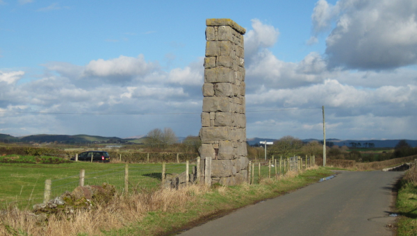
"The sandstone support pillar is the only evidence that remains
of a tramway that crossed over the adjacent road to the nearby
Grievson Pit. The Pinder Ring Pit, south of Lindal Cote, took
its name from the field in which it was sunk. The pit was open from
1872 to 1890, and closed due to flooding. The pit buildings were
demolished in 1905."
More info can be found about the Ulverston Mining Company at
http://lindal-in-furness.co.uk/History/alexbrogden.htm.
Near the bottom of the page, it says "On the road from Crooklands to Urswick, there is a stone
pillar. It was built to support the gantry which took spoil from
Grieveson pit."
This cache is a step back in history. The cache is located near
a pillar of stones, close to the cross roads in the maps below,
which show the evolution through time of this are into a mining
area. Lindal was quite a hub for local mining, and local maps from
the 19th and early 20th centuries show how different the landscape
was back then. Modern maps show no evidence of the activity
in this area.
Map below identified as from 1850 to 1873. The cache is
near the crossroads - no evidence of mining near here
yet.
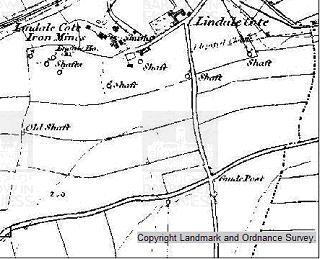
Map
below identified as from 1892 - 1900. Pinder Ring Pit close to
cache site.

Map
below identified from 1914 - 1927. It shows the tram line crossing
the road, reaching towards Grievson Pit.
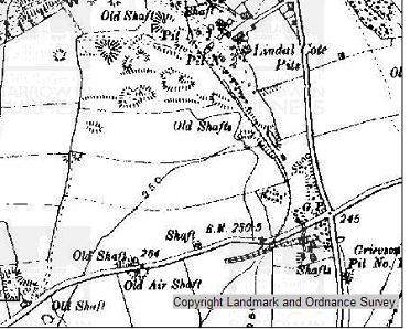
Map
below identiifed as from 1931 - 1938.

Cache is accessible from the road - no need to cross any fences.
It is not located in the stone structure. It's best to park
just around the corner by the gate off the busier road (see
waypoint and note car in picture of cache) - but don't leave the
car there as it blocks the gate. Wheelchair users will be able to
get to the cache site, but might require help to retrieve the
cache.
Great historical maps at http://www.barrowbc.gov.uk/Default.aspx?page=817