Indian Springs Mt. Bethel Artesian Springs ECache EarthCache
Indian Springs Mt. Bethel Artesian Springs ECache
Please note Use of geocaching.com services is subject to the terms and conditions
in our disclaimer.
This cache is placed with the permission of Joe Wood and the Mt. Bethel United Methodist Church, which owns the property it is located on. Please respect the property while caching.

Please PARK AT THE GATE (N 34° 28.294 and W 082° 14.700) and WALK to the cache. It is a short distance (only about 700 feet). The gate is NOT locked, and you have permission to open it. Do NOT try to drive down to the cache! It is deeply rutted and can be very slick if wet. You might get stuck and there is no tow truck nearby. It's a nice walk though, and you can see the M*A*S*H-style sign → halfway down that has milages to places like Jerusalem, Bethlehem, New York, Ware Shoals, and Seattle).
------------------------------------------------------------------
TO LOG THIS EARTHCACHE:
Message or e-mail me with the Answers to at least ONE of the following questions: (Do NOT post them in your log). Please send your answers on the SAME DAY you post your log.
AS AN ALTERNATIVE, You may satisfy the requirements by posting a photo (with you in it if you wish) at the spring.
You do NOT need to wait for a response from me.
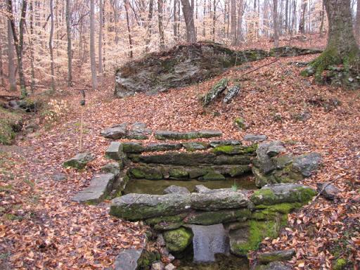
1.) FROM YOUR OBSERVATION: do you see one or more than one spot where water is entering the sping (inside the enclosure)? (You can use a stick to stir up the sediments at the bottom and see where the water is welling up from the spring). 1. = _______________ .
 2.) There is a creek running beside the spring that joins the outflow from the spring just down from the spring (see photo→). Feel the water in both the creek and the spring outflow where they come together. FROM YOUR FEEL AND OBSERVATION, Is the Spring Water Colder, Warmer, or the Same as the temperature of the creek water? 2. = _________.
3.) Also FROM YOUR OBSERVATION: Is the flow from the spring higher, lower, or the same as that of the creek? 3. = ______________.
4.) LOOK at the water level in the spring, AND the water level of the creek even with the spring. Is the elevation of the surface of the water in the spring higher, lower, or the same level at the creek? 4. = ________________.
5.) LOOK at the following chart and FROM YOUR OBSERVATION Estimate the Flow Magnitude or the Flow Rate of the Spring. 5. = ______ Magnitude or _____Pint/Gal. per Minute.
Spring Flow Chart:
1st Magnitude: >44,800 gal/min
2nd Magnitude: 4480 gal/min to 44,800 gal/min
3rd Magnitude: 448 gal/min to 4480 gal/min
4th Magnitude: 100 US gal/min to 448 gal/min
5th Magnitude: 10 to 100 gal/min
6th Magnitude: 1 to 10 gal/min
7th Magnitude: 1 pint to 1 gal/min
8th Magnitude: Less than 1 pint/min
0 Magnitude: No flow (sites of past/historic flow)
Indian Springs (Mt. Bethel Artesian Springs)
Mt. Bethel was organized in 1768 by the Bethel Methodist Society at Indian Springs by the Rev. George Whitefield and families of Arnold, Giraud, Taylor, Sullivan Mitchell, Box, and Wood.
It is the mother to 5 churches and, started the Methodist movement in the 1700's.
The current church was established in 1825. The cemetery here has the grave of several Revolutionary War soldiers as well as some from the Civil War.
A Bit of History:
Originally know as Indian Springs, Mt Bethel Artesian Springs was originally used by the Cherokee of the area as a healing place. They would bring their sick there to be cured by the minerals of the spring water. It was, of course, also used as a source of drinking water.
The Cherokee did not believe in property being "owned" as we know it. To them, the land belonged to the people and the Great Spirit. When white settlers came to the area, the Cherokee shared this sacred place with them, inviting them to worship The Great Spirit here as well .
According to the church history, Huguenot David Giraud (a Revolutionary War soldier buried in the cemetery here), was an indian trader in the late 1780's and knew and worked with the Cherokee. The Cherokee eventually "gave" the springs area to the white settlers to use as a place of worship, and the fledgling Methodist Society built a shelter at the spring to use as a worship place.

Around 1850, the spring, which had come to be owned by the South family, was improved by being "rocked in" by slaves owned by Captain Billy Wood (also buried in the church cemetery).
The rock used was hewn from the large rock outcropping that is seen just behind the springs on the hill in the photo above.↑ and at right.→
An old photo I was shown by Joe Wood shows about 30 people sitting on and around that rock, and in the photo I could even see a couple of the trees that are still here.
In 1851, the church officially bought 10 acres of the land, including the springs, and eventually built the church building now located at the top of the hill. The cemetery has graves dating from the late 1700's.
------------------------------------------------------------------
Now, for the cache:
Evidence exists that the springs here have flowed for generations upon generations.
 Natural springs are important aquatic resources. They are a reliable source of clean, high-quality groundwater that flows at a relatively constant rate and temperature. Because springs are dependable, they are a valuable supply of water for people and wildlife, particularly during droughts.
Mr Wood told me he has never seen this spring run dry in his entire lifetime. He said that at times, the flow into the spring is so great that the water welling up from the bottom actually "humps-up" the surface of the water.
Fish, salamanders, and invertebrates (animals without backbones, such as insects and snails) thrive in clean, spring-fed streams. The moist soil and lush vegetation along stream banks offer food and shelter for birds and other animals.
The Geology of Groundwater:
Groundwater is stored below the Earth's surface within structures called aquifers. An aquifer is made out of permeable or porous rock material and is saturated with groundwater. Aquifers can be defined as confined and unconfined. Confined aquifers are rarer than unconfined aquifers, and occur when the saturated zone lies between two layers of impermeable rock. These types of aquifers result in wells that do not require pumping, or artesian wells. Unconfined aquifers are the most common and only have one layer of impermeable material beneath the saturated zone. Below the permeable aquifer layer, there is usually an impermeable layer that the aquifer rests upon.
 The very top portion of the aquifer is called the water table. Water that is entering the groundwater system is called recharge water. This occurs in what is known as a recharge area where the water table is below the surface of the land. Water reaches the aquifer through a process known as infiltration (percolation). The aquifer can also be considered a zone of saturation. The land above the water table is in the unsaturated zone. Areas where groundwater leaves the system are referred to as discharge areas.
Artesian Springs form where groundwater is forced up and onto the surface through openings in the ground. This is caused by the differences in the slope or "hydraulic gradient" in the aquifer. As rain falls and percolates underground, it exerts pressure on the water already in the aquifer, forcing some to the surface through natural openings.
Artesian springs can occur where faults in the overlying impervious layer allow water to flow upward. Water from an artesian spring is usually free of organic contaminants, making it desiralbe for drinking.
According to Mr Jack Sullivan of the church, local people still use the spring for a water source, and some use it as their ONLY source.
I hope you enjoy your trip to the Indian Springs Earthcache!

The Scout Master at Indian Springs
HAPPY CACHING!!!
FTF HONORS GO TO...OconeeBell (his 1000th find) !!!
-----------------------------------------------------------------------
| I have proudly earned the Geological Society of America's highest level: |
 |
------------------------------------------------------------------------
Additional Hints
(Decrypt)
[Directions: Turn of Hwy 25 onto Mt. Bethel/Dairy Rd. In the sharp curve, turn Left onto Dairy Rd., go 0.2 mi. and Turn Left on Mt. Bethel Ch. Rd. The church is just down the road and GO to the LEFT of The CHURCH to the orange gate. Walk down the road to the cache.]
Treasures
You'll collect a digital Treasure from one of these collections when you find and log this geocache:

Loading Treasures