Ultramafic
Magnificence
Introduction
Those who claim this earth cache will
certainly earn it- but what a reward it offers. So if you are
interested in earth science and the wonder of the wilderness then
this is for you -only problem- it takes three days to walk
there!
Location and
Conditions
The location of this EarthCache is on
the boundary of Fiordland and Mt. Aspiring National Parks in New
Zealand, at a spot known as COW SADDLE. Cow Saddle is the middle
pass/saddle/col on a 5-8 day tramping route known as THE FIVE
PASSES. To get there you need to be experienced in wilderness
tramping a route (as opposed to the much friendlier DOC
tracks). You must carry and be able to use all the necessary
equipment including shelter, cooking gear and food, all weather
clothing and emergency equipment. On this route there are no huts,
marked or cut tracks or Department of Conservation personnel. You
need to be able to handle river crossings, snow, map reading and
navigation and all the weather that Fiordland and Mt Aspiring will
throw at you. Being a wilderness area you are only permitted to
walk to this spot- no landing any aircraft.
Ultramafic
Rock
The Red Mountain range in this area of
Westland is one of the most colourful and geologically interesting
ranges in New Zealand and one of the more unusual world wide. It is
made up of ULTRAMAFIC rock consisting of peridotite or dunite (the
later named after the Dun Mountain in Nelson). ULTRAMAFIC rocks
contain very little quartz or feldspar, and are composed
essentially of ferromagnesium silicates (Iron and Magnesium).
Because of this HIGH IRON CONTENT, these hills weather to a
distinctive, beautiful, deep red, brown rust colour. Being
deficient in Ca, Na, K, P, Bo and other essential minerals no
vegetation grows on them, but they are not "toxic" as often
reported, merely deficient in essential
elements.
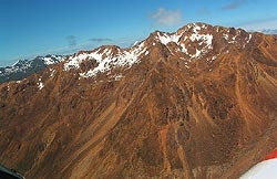
Red Mountain, as seen from above the upper Cascade
Valley
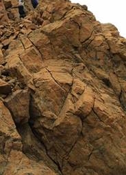
Close up of Ultramafic rock on Fiery Col
The Red Mountain's ultramafic rock has
been thrust up least 10 km from the magma below through the earth's
crust to the surface by the tectonic actions of the Indo-Australian
and Pacific plates. This action results in ultramafic rock
appearing in isolated patches, surrounded by the more usual alpine
rock of greywacke and schist. These colourful patches contrast
dramatically against the surrounding rock and are known as
ULTRAMAFIC INTRUSIONS.
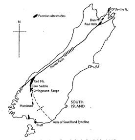
Another striking effect of the tectonic
process is readily apparent as you consider the distribution of
ultramafic intrusions in the South Island. Geologically the other
half of this Red Mountain range lies in Nelson, some 480kms to the
north and is called Red Hills and Dun Mountain. In the past all
these hills and miuntains were adjacent, but on either side of the
alpine fault - Differential movement along the fault over time has
lead to them being now far apart. (see map illustration of this
below).
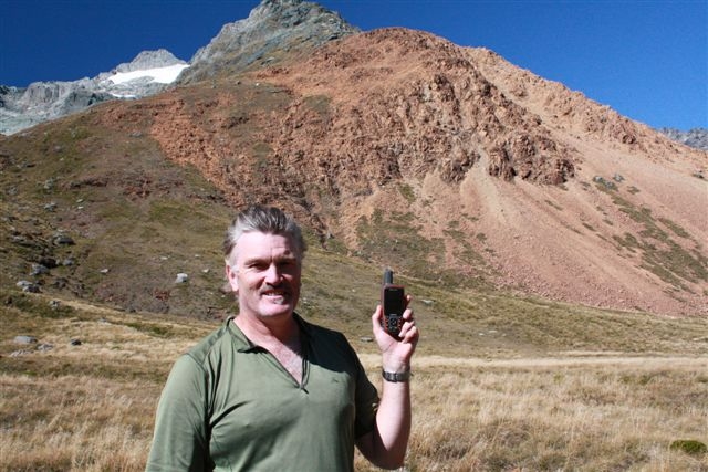
The cache owner at Cow Saddle (24 March 2011). Behind is a face of
Ultramafic rock coming down off Niobe Peak. This location is some
30km south of Red Mountain
At Cow Saddle, the site of this cache,
you can see exposed ULTRAMAFIC rock, where a huge face of it pours
down to the saddle from the south east (see photo of me above). And
then looking up an additional 500 vertical metres to the west you
see the appropriately named Fiery Col where more ultramafic rock is
visible. As you clamber over this rugged col and pass into the
Olivine River Valley the differentiation of the red ultramafic rock
to the east side of your path and the traditional greywacke scree
to the west is striking (see picture below). On a practical level-
for trampers the ultramafic rock is great to walk on- it is rough
like sand paper and gives a great grip for your boots when you
really need it. It also signals its presence with a distinctive
brick like clinking when it bangs together under your
footfall.
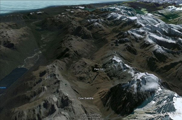
Google Earth image of landscape in this area, showing the
relationship of the three ultramafic intrusions at Cow Saddle and
Fiery Col (bottom centre) and the distant Red Mountain (top
centre). View is looking North
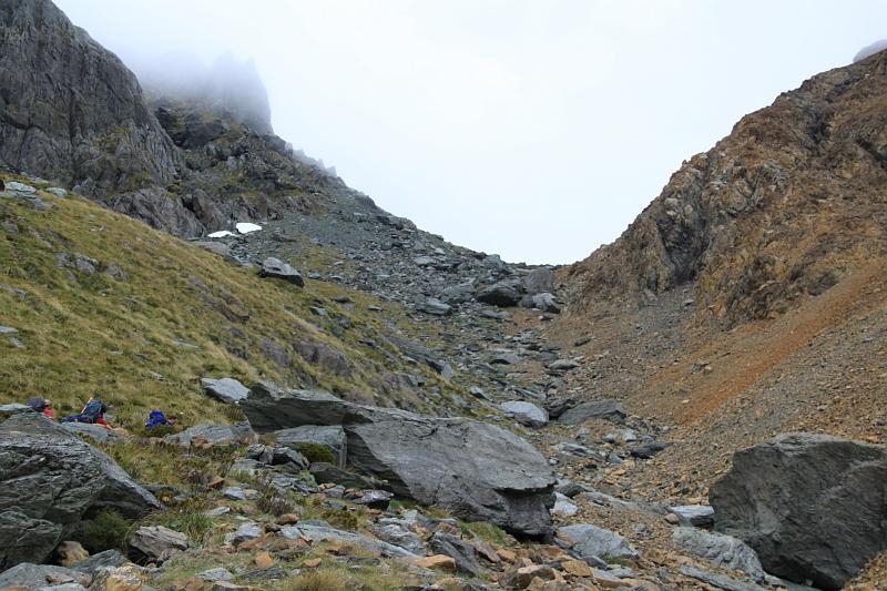
Fiery Col from North- note the distinctive colour difference in
rocks from one side to the other
Claiming the
Cache
The cache coordinates are a location
adjacent to an obvious ROCK set amongst some mountain tarns- If you
are in that spot- hearty congratulations for getting there- and
what a place to be! To log the find please e-mail me back with the
answers to the following questions.
1- At the
coordinates there is a Rock. What type of ROCK is it?
2- What evidence supports your conclusion to answer 1?
3- How do you think this ROCK got to this location?
4- What is the approximate size of the ROCK (Big House? Small
house?, Dump Truck?, Mini bus?, Car?)
5- There is a nice big rounded rock immediately to the west of the
ROCK (good for climbing and sitting on for lunch and drying out wet
gear!)- approximately how far is the top of this sitting rock from
the ROCK?
OPTIONAL- As well as the answers, if you can e-mail me a picture of
you at the ROCK that would be a great (don’t put it in the
gallery though, as that would spoil the questions for
others).
AGAIN OPTIONAL- If the weather permits- please take a photo for the
gallery of yourself at Cow saddle or Fiery Col with your GPS and
some of the plentiful ultramafic rock. This will indeed be a good
record of your mighty exploits. Any tales of your journey would
also be most welcome in the log.
Travel
Safely
This Geocache has been published with the permission of
the NZ Department of Conservation.