Camadas
carbonosas
O Cabo Mondego é um verdadeiro livro da História Geológica do
período Jurássico, entre os 185 e os 120 M. A. (milhões de anos). A
Rota do Jurássico é um conjunto de earthcaches que lhe vão dar
oportunidade de “viver” nos tempos em que os
Megalossáurios calcorreavam este litoral. Ao longo de cerca de 2 km
de arriba, poderá ver sucederem-se diversos paleoambientes,
resultado de regressões e transgressões marinhas ocorridas nesta
zona, apreciar as formações e as estruturas de origem sedimentar,
observar muitos registos fósseis, animais e vegetais,
impressionar-se com as forças tectónicas que ergueram e inclinaram
as bancadas calcárias, enfim, arrebatar-se com a presença de um
verdadeiro tesouro super-antiquíssimo. Um tesouro único, que temos
à nossa disposição e que é de todos nós. Tome atenção especial à
sua preservação – se quiser levar alguma recordação para casa
(rochas, fósseis, etc.) leve-a na máquina fotográfica/GPS ou
telemóvel.
E se trouxer algum saco de plástico faça um CITO (cache in trash
out)!
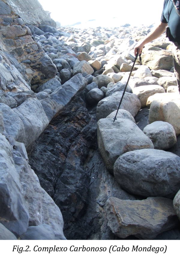
Quando a cobertura arenosa o
permite e a maré está baixa, fica exposta toda uma sucessão regressiva de natureza
lagunar (complexo Carbonoso) correlativa do Oxfordiano Superior
(161-156 milhões de anos). Na base observa-se a transição de uma
barreira com pequenos corpos recifais, para uma laguna salobra com
corbulídeos (moluscos bivalves) e, por fim, uma laguna de água doce
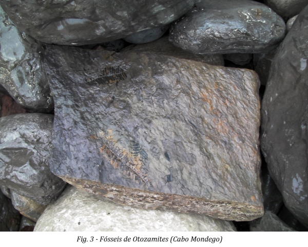
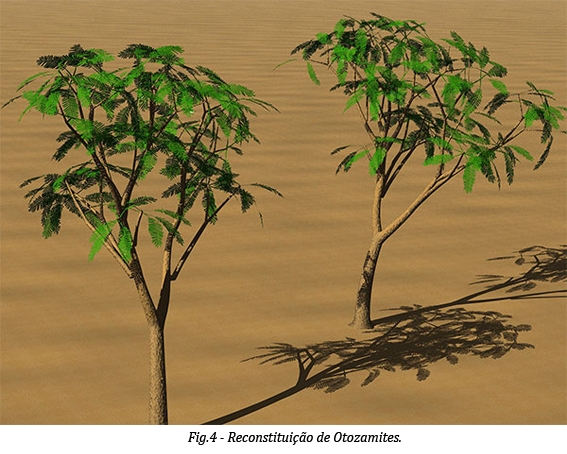
com unios (moluscos bivalves), carófitas (plantas aquáticas) e
fragmentos de folhas de cicadáceas (Otozamites). A
vegetação das margens devia ser luxuriante, de modo que os seus
restos acumulados e incarbonizados levaram à formação das camadas
carbonosas exploradas na antiga mina.
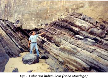
Segue-se uma sucessão monótona de calcários e
de calcários margosos laminados com fragmentos de bivalves marinhos
(camadas marinhas ricas em lamelibrânquios) que se prolonga para
Sul até à Pedra do Roaz. Esta mesma sucessão é a que se encontra
exposta no imenso talude da pedreira da fábrica de cal hidráulica.
Na sua parte superior existem bancadas de calcários compactos e de
arenito
vermelho-amarelado, onde se podem observar pegadas de dinossáurios
carnívoros do género Megalossaurus.
“Subsídios
para um roteiro geoturístico do litoral português: o exemplo da
Figueira da Foz”, Callapez, Pedro Miguel in
Por Terras da Figueira (2008); Edição: Kiwanis Clube da Figueira da
Foz
http://fossil.uc.pt/pags/fbm_coleoides.dwt#
sucessão
regressiva – conjunto de estratos
que revela, pela sua natureza litológica e conteúdo fóssil, uma
regressão marinha, ou seja, o recuo das águas do mar relativamente
à linha de costa. Na praia da Pedra da Nau encontra-se, na base da
falésia, por baixo dos edifícios fabris, uma sucessão de estrados
inclinados para sul (no sentido da Figueira da Foz), que traduzem,
no mesmo sentido, a evolução de um ambiente recifal de águas
salgadas de pouca profundidade para um ambiente lagunar de água
salobra e, finalmente, para um ambiente de laguna com água doce. No
tempo em que estas alterações ambientais se sucediam (Jurássico
Superior), estes estratos depositavam-se e iam-se sobrepondo
verticalmente, uns sobre os outros. Milhões de anos mais tarde, o
levantamento da serra fê-los tombar para sul.
sucessão
monótona – conjunto de estratos
sucessivos e semelhantes entre si. Nesta sucessão de estratos a
existência de bivalves marinhos e calcários compactos revela a
posterior transgressão marinha (avanço das águas do mar
relativamente à linha de costa).
arenito
– rocha sedimentar detrítica,
consolidada, constituída por material arenoso aglutinado por um
cimento natural (carbonatado, silicioso ou ferruginoso). A sua
ocorrência traduz uma deposição ou em ambientes continentais (rios,
lagos, etc.), ou em marinhos costeiros (praias, deltas) ou em
marinhos de talude continental.
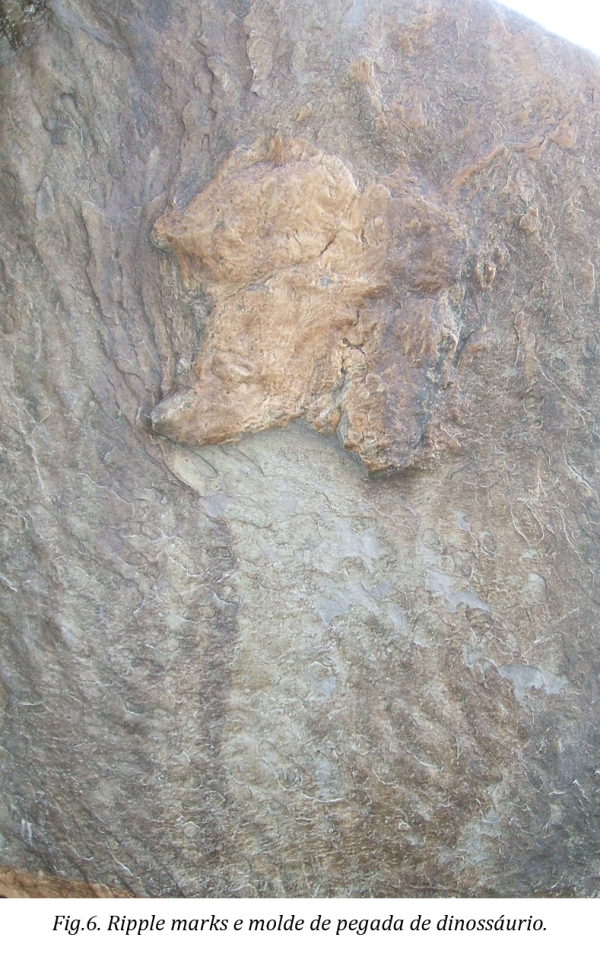
Nos arenitos aflorantes junto
do molde de pegada de dinossáurio podem observar-se ripple marks que são marcas de ondulação, típicas de
ambientes intermareais, a fazer crer noutra regressão
marinha.
Revisto por F. C. Lopes
(Geólogo)
ATENÇÃO
À MARÉ!
Para
aceder ao local deve escolher uma hora de maré-baixa.
Nas
coordenadas indicadas faça a medição da camada
carbonosa aí presente.
Envie
essa medida para o meu email para que lhe seja autorizado o log
desta earthcache.
Carbonaceous layers
The Cabo
Mondego is
a true
book of
Geological History of
the Jurassic period, between
185 and
120 M.
A. (million
years). “Route of
Jurassic” is a set of
earth caches that will give you the opportunity to "live" in
the days when the Megalosaurs walked over
this coast. Over
about 2 km of cliff you can see
different paleoenvironments result of marine
transgressions and regressions occurred in this
area, examine the sediment formations,
observe many
records fossils,
impress themselves with the limestone strata that were tilted by
tectonic forces and finally to feel a
super-ancient
real treasure. It’s a unique treasure
that we have
at our disposal
and that belongs
to all of us. Take special care to preserve the environment -
if you want to
take home some souvenir (rocks, fossils,
etc.) take it
in your camera
/ GPS
or mobile phone.
And if
you bring a
plastic bag, make
a CITO
(cache in
trash out)!
When the tide is low and the sand coverture allows you can
see the regressive
succession of nature lagoon (Carbonic complex) from about
161-156 million years ago – Upper Oxford. In the base you can
observe the transition of the reef coral to a brackish lagoon with
corbulidae (bivalve molluscs) and finally one freshwater lagoon
with Unio (bivalve molluscs), charophyte (aquatic plants) and
fragments of cycads leaves (Otozamites –
fig.3 and 4). The vegetation of the margins should be luxuriant, so
that their
accumulated and carbonized remains led to the
formation of carbonaceous layers
explored in the
old mine. (fig.
2)
It follows a monotone succession of laminated
limestone and marly limestone with fragments of marine bivalve (marine layers
rich in lamellibranch) which
extends south to the Stone of Roaz (fig.5). This succession is the same that is exposed in
the huge slope of the quarry explored by the hydraulic lime
factory. In its top there are layers of compact limestone and
yellowish red sandstone, where one can observe
carnivore dinosaur footprint of the genus Megalossaurus.
regressive succession
– set of strata that reveals, by its
lithological nature and fossil content, one marine regression, in
other words, the retreat of the sea in relation to the
shoreline. In Pedra da Nau’s beach one can find, in the base
of the cliff, underneath the factory buildings, a succession of
inclinated strata to south (on the way to Figueira da Foz), that
show, on the same way, the evolution from a recifal environment of
shallow saltwater to one of lagoonal of brackish water and
finally to one of lagoonal freshwater. At the
time that these environmental changes took place (Upper Jurassic),
these strata layered and werevertically overlapping.
Millions of years later, the lifting of the hill made them fall to
the south.
monotone succession
– set of successive and similar strata. In
this succession the existence of marine bivalve and compact
limestone reveal a posterior marine transgression (advancement of
seawater in relation to the shoreline).
sandstone – detritic consolidated sedimentary rock, formed by
sand material bonded by a natural cement (carbonated, siliceous or ferruginous). Its occurrence
reflects one deposition in continental environments (rivers, lakes,
etc.), or in coastal marine (beaches, deltas, etc.) or in marine
environments of the continental slope.
In sandstones in outcrop along the mold
of the dinosaur footprint one can observe
ripple marks, typical of intertidal environments,
suggesting another marine regression. (fig. 6)
ATTENTION TO THE TIDE!
To access the place you should choose
a period of low tide.
At the given coordinates, please
make the measurement of the existent carbonaceous
layer. Send the answer to my e-mail so that I can allow you to
log this earthcache.