Stockholm is Not! [SWE]
Många olika planer har funnits på att förändra Stockholm, många har som tur är aldrig blivit av. Bland annat fanns förslag på att järnvägsstäckningen över Gamla stan skulle dras längst Skeppsbron, nedanför slottet, förbi Kungsträdgården med en slutstation vid Östermalmstorg.
Den första stadsplan uppkom efter branden som drabbade sydvästra Stadsholmen, nuvarande Gamla stan, den 1 september 1625. Branden, som kallas Stora branden 1625, var en katastrof och totalförstörde sydvästra delen av Stadsholmen. I juni 1626 fick de fastighetsägare som drabbats av branden löfte av kungen om skattefrihet i sex år, förutsättning var att man följde en ny upprättad stadsplan och att husen byggdes i sten.
Clas Larsson Fleming utvecklade tillsammans med sina kollegor, på 1630- och 1640-talen, de första regleringarna på Norr- och Södermalm. Idéerna kom från renässansen, det skulle vara regelbundna och rätvinkliga rutnät av gator och kvarter.
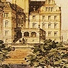
Albert Lindhagen presenterade Lindhagenplanen 1866. Den innehåller ett reglerat gatunät inspirerat av Paris, rutnät och stora fyrkantiga kvarter omgivet och genomkorsat av stora boulevarder. Att bygga gränsboulevarden Valhallavägen ansågs onödigt där den låg i oländig terräng i stadens ytterkant.
Yngve Larsson kom att kallas "sitt århundrades främste svenska stadsbyggare" och "århundradets gigant inom stockholmspolitiken". Yngve Larsson låg bakom mycket av Stockholms utveckling under 1900-talet. Framför allt regleringen av Norrmalm, men även Slussen, Stockholms tunnelbana mm. 1945 beslutade stadsfullmäktige att regleringen av Nedre Norrmalm skulle genomföras, planen realiserades under 1950-, 60- och 70-talen. Genomförandet resulterade i att de gamla Klarakvarteren fick ge plats åt det moderna Stockholm, samtidigt som tunnelbanans utbyggnad underlättades. Rivningarna började 1952, och det avslutades igenom att Gallerian stod klar 1977.
Koordinaterna pekar på Gamla stan, här har det inte hänt mycket 
Stockholm is Not! [ENG]
Many different plans have been in changing Stockholm, many have fortunately never been relaized. There were suggestions that the railways passed Gamla Stans would be at Skeppsbron, below the castle, past Kungsträdgården with a final stop at Östermalmstorg.
The first development plan emerged after the fire that hit southwestern Stadsholmen, current Gamla Stan, on 1 September 1625th. The fire, called the Great Fire in 1625, was a disaster and completely destroyed the southwestern part of Stadsholmen. In June 1626 the property owners affected by the fire got a promise from the king's of tax exemption for six years, provided that the followed the new development plan and that the houses were built in stone.
Clas Larsson Fleming developed with his colleagues in 1630 and 1640’s the first regulations on Norrmalm and Södermalm. The ideas came from the Renaissance; there would be regular and rectangular streets and neighborhoods.
Albert Lindhagen presented Lindhagensplan 1866. It contains a regulated street layout inspired by Paris, grid and large square blocks surrounded and crossed by great boulevards. Building the border Boulevard Valhallavägen was considered unnecessary as it lay in the rugged terrain of the city's edge.
Yngve Larsson came to be called "the century's foremost Swedish city builder" and "century giant in Stockholm policy". Yngve Larsson was behind much of Stockholm's development during the 1900s. In particular, the regulation of Norrmalm, but also Slussen, Stockholm Subway, etc. 1945 City Council decided that the regulation of Lower Norrmalm would be implemented, the plan was realized in 1950 -, 60 - and 70's. The implementation resulted in the old Klara district had given place to the modern Stockholm, while the underground expansion was made possible. Demolitions began in 1952, and it was completed in 1977 through the opening of Gallerian in 1977.
The above coordinates points at Gamla stan, not much happen here
Fråga 1
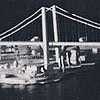 |
AAAA = Endast en av två blev av. Till den som saknas finns många förslag på lösningar, gamla som nya. Vilket år kom förslaget på bilden?
BB = Hur många vertikala pelare är det i mittensektionen på den bro som byggdes? (OBS! Räkna bara en sida)
AAAA = Only one of two was built. For the missing one there have been many solutions, old and new. From what year is the proposal in the picture?
BB = How many vertical pillars are there in the middle section of the bridge that was built? (Note! Count on side only) |
|
|
Fråga 2
 |
CCCC = Gamla stan har man haft planer på att riva flera gånger, en London inspirerad byggnad skulle uppföras enligt ett förslag. Vilket år kom förslaget?
DD = Hur många meter hög är byggnaden i London?
CCCC = There have been many planes to demolish Old Town; a London-inspired building would be built as proposed. What year was the proposal?
DD = How many meters high is the building in London? |
|
|
Fråga 3
 |
EEEE = Sveavägens förlängning till Gamla stan har diskuterats sen Nicodemus Tessin d.y. dagar på 1700-talet. Till och med vilket år fanns den planen kvar?
FF = Hur många småblock hög är den första sektionen av Kristallvertikalaccenten?
EEEE = The extension of Sveavägen to Old Town has been discussed since Nicodemus Tessin the Younger days in the 1700s. Until what year was the plan last?
FF = How many small blocks high is the first section of the Kristallvertikalaccent? |
|
|
Fråga 4
 |
GGGG = Storkyrkan har flera gånger beslutats att riva, bland annat av Gustav III som ville resa en staty av sig själv på platsen, vilket år skulle firas?
H = Delar av Storkyrkan har rivits, ta sista siffran i året när stenläggningen som markerar den gamla grunden las.
GGGG = There have been many decisions to tear down Storkyrkan, Gustav III wanted to erect a statue of himself on the spot, which year would be celebrated?
H = Parts of Storkyrkan has been torn down, take the last digit of year when the pavement that marks the old foundation was set. |
The final coordinates are:
N 59° 20.XXX
E 018° 05.YYY
Where:
XXX = (EEEE-GGGG) + BB + (DD*2) + (FF*2) + 7
YYY = (AAAA-CCCC) + (BB*H) + FF + H
Control your coordinates at: Geochecker.com.