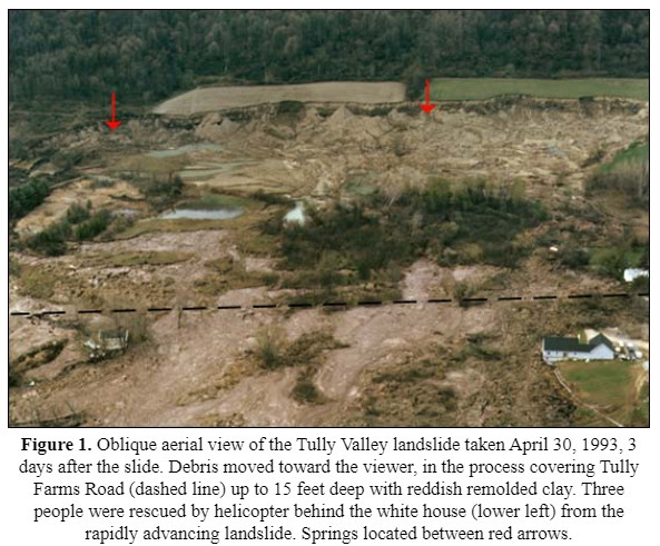
Without warning in the middle of the day on April 27, 1993, a landslide in the Tully Valley covered Tully Farms Road with as much as 16 feet of clay, destroyed three houses, lead to the evacuation of four other houses and caused a loss of drinking water for 15 homes north of the slide area. Three people were rescued from their homes by helicopter from the middle of the landslide. A total of 49 acres were transformed in a just few hours.
Tully Valley is a roughly north–south valley about 6 miles long and about 1 mile wide that was formed by glaciers retreating from the area 14,000 years ago. The valley walls consist of glacial till (gravel, sand, silt, and clay) covering bedrock. During studies following the 1993 slide, USGS scientists recognized features suggestive of past landslides at 73 sites within the area surrounding the Tully Valley, and discovered evidence of a very similar slide roughly 6,100 years ago that was only 300 feet north of the 1993 slide.
The 1993 landslide was a complex earth-slump/mudflow that started on the lower slope of Bare Mountain and moved onto the valley floor. Although the landslide stopped moving a few hours after it started, water flowing from fresh and brackish springs at the base of the Mountain behind the slide and the saturation of the clay at the site threatened to restart the slide and kept people away from their homes for two weeks while a variety of remedial steps (draining water, construction of ditches and road clearing) were taken to stabilize the slide area.
Today you can see remnants of the slide in the form of hummocks (unusual mounds of earth) at the bottom of both the 1993 slide and the much earlier slide that happened at the intersection of Webster Road, just north of the 1993 slide.
To log this cache, you must email or message us the answers to the following questions, before or immediately after submitting your found log:
1) On which side of Tully Farms Road (east or west) are the hummocks the tallest?
2) Why are the hummocks taller on one side of the road?
3) What is your estimate of the height of the tallest hummock easily visible from the posted coordinates?
a) 5 feet,
b) 10 feet
c) 20 feet
d) 30 feet
Please do not post your answers in your log. Photos are not required, but may be posted. If you post a photo, please do not reveal the answers to the questions in your photo! If we do not receive the answers before or shortly after you post your log, we will delete your log (i.e. we are not going to chase you for the answers).
Additional information about this landslide and pictures of the slide from 1993, can be found at:
https://www.usgs.gov/science-explorer-results?es=Tully+Farms+Landslide and http://pubs.usgs.gov/fs/fs13-98
Our thanks to Donald L. Pair and William M. Kappel of the Geology Department at University of Dayton, Dayton, OH for their excellent summary of the extensive research surrounding the landslide which was the basis for this description.