Most rivers initially start by a steady flow of water following
the course of least resistance. The water flows where it can and
starts to maintain this pattern as the water remains consistent.
While the water does what it likes the river bed is subject to
natural forces that can manipulate the flow and direction of the
water over time. Erosion and the properties of the underlying
materials can change the face of a river over the years. Which
brings us to this Earthcache: The Etobicoke Creek Meander...For
Now
As you wander around GZ you will quickly see that this creek is
subject to many such meanders for most of its length. Why? The
underlying materials are soft (most of the creek banks are lined
with shale) and as the water begins to pummel a certain area it
starts to erode. As you will see the rate of flow in the water
changes depending on where in the meander it is, this results in
removal of material in the "higher speed" zones and deposits of
material in the "slower speed" zones. Depending on how closely you
look you may get to perceive the change that is occuring in this
particular section of Etobicoke Creek.
In this diagram we can see the way in which a meander can change
to form an oxbow lake. The arrows represent the direction of the
water flow. 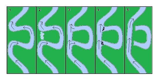 At first (1) the
water proceeds to follow the course of the meander and slowly
erosion and flooding continue to change the surrounding creek bed.
(2) The movement of materials in the creek bed continue as
it begins to deteriorate the width of the neck (or when flooding is
a factor it can reduce the height of that area by washing out top
soil and other sediment). (3) Once the neck is consumed by
the natural process it may still feed the bend of the meander but
the flow would be greatly reduced. (4) Before long, sediment
begins to fill the openings of the bend (or cutoff) and starts to
all but eliminate any real flow from the river into this former
component. (5) When enough sediment has come to rest at the
openings of the bend, it will no longer be a part of the river and
will now be considered an oxbow lake. Separated by the same forces
that created it (almost sounds like a geological soap opera).
At first (1) the
water proceeds to follow the course of the meander and slowly
erosion and flooding continue to change the surrounding creek bed.
(2) The movement of materials in the creek bed continue as
it begins to deteriorate the width of the neck (or when flooding is
a factor it can reduce the height of that area by washing out top
soil and other sediment). (3) Once the neck is consumed by
the natural process it may still feed the bend of the meander but
the flow would be greatly reduced. (4) Before long, sediment
begins to fill the openings of the bend (or cutoff) and starts to
all but eliminate any real flow from the river into this former
component. (5) When enough sediment has come to rest at the
openings of the bend, it will no longer be a part of the river and
will now be considered an oxbow lake. Separated by the same forces
that created it (almost sounds like a geological soap opera).
In order to log this EarthCache you will need to answer a few
things based on your observations at GZ. Please email me your
answers to these questions and then feel free to log your find:
1. Comparing this meander to the diagram in the description,
at what phase would you say this meander is? Please
explain.
2. Take a look at the "neck" of the meander, what is the
greater factor to its transition: Erosion or Flooding? Please
explain.
3. Measures have been taken to maintain the outside wall of
the bend, what are they and why are they needed?
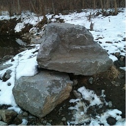
This location is great for wildlife, bring your camera you never
know what you will see. Have fun, be safe, happy caching!


References
1.Meanders on
Wikipedia
2.Oxbow lakes on
Wikipedia
3.Brampton
Trail Guide