Erosion in the Dells EarthCache
Please note Use of geocaching.com services is subject to the terms and conditions
in our disclaimer.
**************IMPORTANT: In order to claim this as "found", you must complete the logging requirements at the bottom of the page.****************This is not your typical geocache, it is an EarthCache, you will not be looking for a "cache container" rather, an EarthCache is designed to bring you to a geological feature. See http://www.earthcache.org/ for further details.
Erosion
What is erosion? Erosion is the process of the earth wearing away or breaking down. Water in it’s different forms are most often the cause of erosion. When water or other elements like air or pollution wear away at the earth it is called “weathering”. Even a large piece of bedrock can be made smaller over time by small pieces being worn away a bit at a time or even by chemical reactions taking place that loosen the bonds holding the rock together. While there are other types of erosion, here are some of the more common ways that our earth is worn away.
Water Erosion: As I said, water is the most common erosional agent and the most common way for it to do that is with running water in streams. According to Matt Rosenberg: “Streams erode their banks in three different ways: 1) the hydraulic action of the water itself moves the sediments, 2) water acts to corrode sediments by removing ions and dissolving them, and 3) particles in the water strike bedrock and erode it.” Water can also wear away at the soil and rock in the form of rain and snowfall or even with standing water.
Air Erosion: Erosion by wind is known as Aeolian (or Eolian) erosion (named after Aeolus, the Greek god of winds) and occurs almost always in deserts. Small particles of rock or soil can be carried away or moved as the wind blows on it. Aeolian erosion of sand in the desert is partially responsible for the formation of sand dunes.
Ice Erosions: Considering our cold climate, ice erosion is quite common in Wisconsin. This form of water is even more powerful than running water erosion. Water seeps into small spaces inside the rocks and soil, freezes and expands. This can be quite destructive! Think of all of the potholes on the roads in the spring because of the effects of ice erosions on the roads. Glaciers are the largest forms of ice erosion. The large amounts of ice all in one place can dislodge and move very large rocks and carry them great distances.
Wave Erosion: This is another type of water erosion and it takes place in coastal areas where the waves are strong. Matt Rosenburg says: “The power of oceanic waves is awesome, large storm waves can produce 2000 pounds of pressure per square foot. The pure energy of waves along with the chemical content of the water is what erodes the rock of the coastline.” Wave erosion mostly moves sand along on the beach as the waves pick up pieces of sand and deposit them somewhere else. It also can beat against the rocks on the shore.
Biotic Weathering: “Bio” means life. So this type of weathering is the wearing down caused by plants, animals and other living organisms. The most common example of biotic weathering would be tree or other plant roots. Those roots dig deep into the cracks in a rock, creating a wedge that can widen and expand the cracks. It also provides more space for water to come in and do its damage at the same time. Other types of biotic weathering are digging animals, microscopic plants and animals, algae and fungi. Humans are living things so we fall into this category. And we do our fair share of damage too! Think of all of the trails worn into the grass as we walk off trail to find geocaches (and other muggle activities).
Rocky Arbor State Park
You will need to visit Rocky Arbor State Park in Wisconsin Dells to complete this EarthCache. This is what the DNR has to say about Rocky Arbor: “The 244-acre Rocky Arbor State Park is within 1.5 miles of the popular Wisconsin Dells vacation community. Eighty-nine wooded campsites offer seclusion, while pine trees and sandstone bluffs offer a cool escape to the picnicker or hiker in this summer park. The park has a 1-mile self-guided nature trail. Walk quietly, stop often, listen, and watch for wildlife. You may see deer, raccoons, squirrels, bats, and chipmunks. The campground has showers, flush toilets, and electricity.”
Also from their website regarding how to get there: “From Interstate Highway 90/94, take the U.S. Highway 12/16 exit on the north side of Wisconsin Dells. Go east on Highway 12/16 about .8 mile; the park entrance will be on your right. From Wisconsin Dells, take State Highway 13/16/23 west to Highway U.S. 12. Go right (northwest) on Highway 12/16 about 1.2 miles; the park entrance will be on your left. The park entrance is at latitude 43° 38' 27.3", longitude 89° 48' 7.0"
To enter any WI State Park you will need to pay a vehicle entrance fee. To purchase an annual pass it is $25, for the day it is $7, or you can just go for an hour for $5. Non-residents have to pay a little more and seniors pay less. Check out the WI DNR website for more information regarding fees and other information: www.dnr.wi.gov Rocky Arbor S.P. is closed late fall – early spring to motor vehicles. If you come when it is closed you are welcome to park at the gate and walk in.
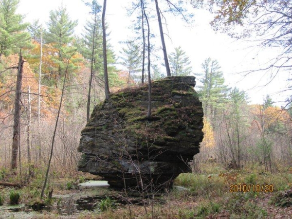
A Rock in Rocky Arbor
You are looking for a large rock along the Nature Trail at Rocky Arbor State Park. I thought that this stubborn piece of rock was beautiful and I was sure I could find a reason to bring people here to see it. I decided that it was a great way to view the effects of erosion on the rocks in Wisconsin Dells. You will need to visit this rock and answer some questions to complete this EarthCache. The trail is approximately a mile long loop and starts at the back of the area by the main entrance. The rock is on the lower section of trail along the river. About .2 miles past the rock is a set of stairs that will take you up to the higher section of the loop which will head back to the main entrance and campground.
Logging Requirements
Please send me an email with the answers to the following questions. Please do not put these answers in your Found It log because that would give the answers away for other people.
1. Tell me what kind of erosion is taking place on this rock?
2. Describe the eroding forces and how they are wearing away at the rock.
3. Estimate and tell me how tall the rock is. Also, how high and wide is the portion that is worn away?
BONUS: We are no longer allowed to require a photo for submission requirements but you would make this CO very happy if you would take a picture of your caching team along the trail or in front of the rock and choose to upload it. Again, not a requirement, it just would be nice. :-)
The Geocache Notification Form has been submitted to Steve Rodenkirch,, Property Manager of the Wisconsin DNR. Geocaches placed on Wisconsin Department of Natural Resource managed lands require permission by means of a notification form. Please print out a paper copy of the notification form, fill in all required information, then submit it to the land manager. The DNR Notification form and land manager information can be obtained at: (visit link)
Congratulations go to RemembertheChief for being the FTF on 4/6/11!
| I have earned GSA's highest level: |
 |

Additional Hints
(No hints available.)
Treasures
You'll collect a digital Treasure from one of these collections when you find and log this geocache:

Loading Treasures