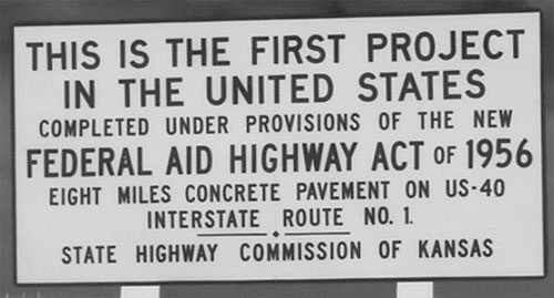
The cache is located along a frontage road near the east end of this historic stretch of Interstate. Along the Interstate just south of the cache is a new sign erected to commemorate this piece of U.S. history.
You are looking for an ammo can painted by 1BigWally that we won at the Moose Pancakes 2011 event. Initial contents include a logbook, pen, a little bit of swag and a one-of-a-kind FTF prize related to the cache.
On October 15, 1990, President George H. W. Bush signed Public Law 101-427 changing the official name of the Interstate System to honor the President who did so much to bring it about. Based on an amendment in the Intermodal Surface Transportation Efficiency Act of 1991 (ISTEA), it is now called the Dwight D. Eisenhower National System of Interstate and Defense Highways.
Interesting Interstate Facts
As of 2006, the system covers 46,876 miles.
Highest: 11,158 ft/3,401 m: I-70 in the Eisenhower Tunnel at the Continental Divide in the Colorado Rocky Mountains
Lowest (under water): -107 ft/-33 m: I-95 in the Fort McHenry Tunnel under the Inner Harbor in Baltimore, Maryland.
Longest: 3,020.54 mi (4,861 km): I-90 from Seattle, Washington to Boston, Massachusetts
Shortest (unsigned): 0.7 mi (1.1 km): I-878, a portion of New York State Route 878 adjacent to John F. Kennedy International Airport in Queens, New York
Widest (most grade-separated access-controlled through lanes): 21 lanes—I-5 along a 2-mile (3.2 km) section between I-805 and SR-56 in San Diego, which was completed in April 2007
Narrowest: 2 lanes—I-93 in New Hampshire where it runs through Franconia Notch State Park where it also lacks breakdown lanes and I-81 on the southern span of the Thousand Islands Bridge, are the only instances of a two lane highway – also called a Super-2 parkway – on the Interstate system.
Congratulations to 1BigWally for the FTF!