This is one of three caches we placed in the Little Roche-A-Cri
Creek public use area in June of 2011. The three caches are:
Logging a Smiley,
Logging a Multi, and
Logging a 'Real Purdy' Spot. If all three are done together,
and in that order, they will take about an hour to do, and you will
walk no more than a mile and a half total. Use the logging road to
go in, then use that and the faint trail along and above the creek
to get to the caches. At no time will you have to go down to the
creek level or go far away from a trail, nor will you have to walk
through any wooded areas except near the creek. The adjacent wooded
property north and west of the logged area is private, so do not go
that way.
Note on 10/17/2011: The popple has grown up
enough to obscure most of the logging road. These "twigs" are over
eight feet tall in some places. Also, many trees on this DNR
property that were not logged a year ago were broken off or
uprooted in the 9/2/2011 wind storm that went through the area. The
storm damage has necessitated the relocation of this, the third
cache in this series. It is findable, but you will work for the
smiley on this cache.
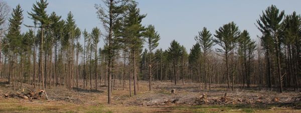
In the fall of 2010, much of this acreage was selectively
logged. We never explored this place before the logging, so we
don't know what it looked like then, but all of us who visit here
now will have the chance to see the results of the logging and how
the land here renews itself over time. Every time we have visited
this logged area, there are different things to see. Turkey hunters
use this land in the spring, and deer hunters (bow and rifle) use
this in their respective fall seasons. Please keep this in mind
when planning a visit and if you see other vehicles in the parking
lot at those times. Caches are available in the winter, but no
parts of any are winter-friendly.
Our coordinates here may be a bit off on these three caches,
since every time we visited and took readings, we came up with
something different. Use your geosense and the hints to make the
finds. Please replace all containers exactly as you found them, and
make sure that they are covered with natural camo when you
leave.

This cache is the farthest of the
three from the parking area. It also sustained the brunt of the
windstorm damage. The original GZ was almost under a large fallen
tree when we went to check a few week safter the storm, so we
didn’t think the cache had survived. Luckily, jar42 was brave
enough to take on the task of seeing what he could find, and he
came up with the container, leaving it for us to retrieve from a
new spot with a ‘real purdy’ view . We chose to keep
the cache fairly close to that spot and to the original spot, so
there is still a view of the creek from GZ. We have upped the
terrain level because of all the downed trees you will have to
avoid, plus there’s not much of a trail now. Watch your step,
especially when you are near to the edge above the
creek.
While you are hiking to the cache,
take in all the different areas that you are going through. Look
for wildlife and wildflowers. Notice how the logged area renews
itself over time. As you approach GZ, no matter which route you
come by, you will soon see the creek. You will be above it, and you
can look down on it as it flows from your left to your
right.
We first visited this area before
the trees were fully leafed out, so we had excellent views of the
bottomlands and the windings of the water. When we placed the cache
in early June, a lot had changed, as things greened up and leafed
out, but we could still see the creek. You might find yourself
spending some time here as we did, watching the water, taking in
the beautiful simplicity of nature at this location, even after
nature decided to rearrange a bit of the scenery here. A geocaching
friend of our would call this place a 'real purdy' spot. Enjoy the
views, enjoy your hike, and most of all, enjoy logging this 'real
purdy' spot!

This cache is in a public hunting
area,
so wear blaze orange and take precautions
if you search for this cache during hunting season.
The Geocache Notification Form has been submitted to Justine
Hasz of the Wisconsin Rapids office of the Wisconsin DNR. Geocaches
placed on Wisconsin Department of Natural Resource managed lands
require permission by means of a notification form. Please print
out a paper copy of the notification form, fill in all required
information, then submit it to the land manager. The DNR
Notification form and land manager information can be obtained by
looking at this page on the WGA website.