Things you will need to log this Earthcache:
- GPS
- Camera (optional)
To log your find, please E-mail me via my profile, the answers to the following questions:
- At the posted waypoint, look down the slope and count the number of beach ridges you can see. You can walk down the slope to count them too. How many did you count?
- Using your GPS or by estimation, determine the elevation change from the first beach ridge to the last. Using the average of 0.11" per year (11" per century). Tell me how many years the land took to rise to create all of the beach ridges you counted.
Elevation Change in Inches / 0.11 = Years
- Where the trail exposes the material of the beach ridges, describe to me the material.
- Not required but always appreciated, post to your on-line log a photo of your GPS. Your face can be included if you so wish.
Definition of Terms
Crustal Rebound
Sometimes called post-glacial rebound, continental rebound, isostatic rebound or glacial isostatic adjustment. Is the upward movement of the Earth's crust that was depressed by the weight of ice sheets during the last glaciation period. This process is known as isostasy.
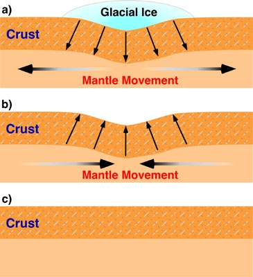
The three stages of Crustal Rebound.
Beach Ridge
A wave deposited or wave swept ridge running parallel to a shoreline. It is commonly composed of sand as well as sediment worked from underlying beach material. A fall in water level or an uplift of land can isolate a beach ridge from the body of water that created it.

Beach Ridges.
The Geology
The geologic story of Mackinac Island is long and varied. This Earthcache will focus on a brief period around 12,000 years. Prior to this time, glaciers were present. The thickness of the glaciers have been estimated to be from 6,000 to 10,000 feet (1.14 - 1.89 miles). The weight of the ice was tremendous. The weight of the ice over the thousands of years that it existed pressed down on the Earth's surface. The bedrock was pushed down below it's original elevation.
As the glaciers retreated, the weight was removed from the bedrock. Slowly over time the bedrock started to rebound. This process of crustal rebounding is continuing to this day. The rate of crustal rebounding around Mackinac Island is currently 9" to 12" per 100 years. The rate of rebounding was the greatest soon after the ice melted. Although the rate is slowing down, it is still expected to continue for another 1,000 years.

Rates Of Crustal Rebound.
As the glaciers melted and retreated to the north, a lake was formed, which was known as Lake Algonquin. It's shoreline was just above the posted waypoint. As the ice continued to melt, new outlets were uncovered that allowed the water to drain away. This and the crustal rebounding effectively lowered the level of the lake that surrounded Mackinac Island. The lowering of Lake Algonquin did not happen quickly or evenly. The water level changed in stages. I used the word "changed" as not only did the water level lower, but the land was rising.
I've brought you here to see some of the ancient shorelines that were formed on Mackinac Island. There were three main Lake Algonquin stages that formed major shorelines were the bedrock was eroded. The shorelines that you will examine formed over a short period of geologic time. If the lake level remained stationary for longer periods of time, the bedrock would have been eroded. What we see here is a series of beach ridges spaced closely together in terms of elevation along a gentle slope.

Area of Ancient Shorelines.
References used:
- http://www.michigan.gov/documents/deq/Glacial_History_Bergquist_306034_7.pdf
- http://earthscience-longoria.blogspot.com/2009/03/ice-sheets-and-glacial-rebound.html
- http://www.geo.msu.edu/geogmich