The Esker Among Us EarthCache
-
Difficulty:
-

-
Terrain:
-
Size:  (other)
Please note Use of geocaching.com services is subject to the terms and conditions
in our disclaimer.
Eskers are snake-like ridges formed by melting glaciers. Meltwater trying to escape from beneath a glacier forms tunnels underneath the ice. Following paths of weakest points in the ice as the water moves downward, the tunnels formed by the water wind along in a curving manner. Throughout its travel, the water deposits silt and rocks which it accumulated during its movement. Eventually the water reaches the margins of the glacier where it becomes confined within the ice walls of the glacier. The water continues to deposit the silt and rocks that it accumulated. Because the stream is restricted by the glacier walls, the deposits gradually build up above ground level underneath the glacier. As the glacier melts away, the icy walls and roofs of the tunnels melt, leaving long, winding ridges of gravel and sand that were deposited during the water's flow. 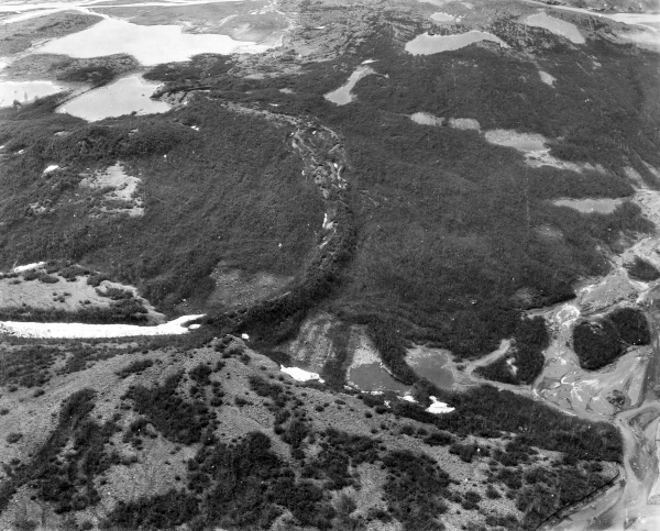
PHOTO CREDIT: U.S. Geological Survey Photographic Library
Like other river systems, the eskers left by glacial water are sometimes in a network similar to a branching system of tributaries. The heights of eskers vary from just a few feet to more than several hundred feet. Eskers range from less than a mile to dozens of miles in length. 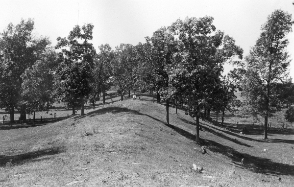
PHOTO CREDIT: U.S. Geological Survey Photographic Library
Eskers left by retreating glaciers were frequently used by travelers as elevated roadways. More recently eskers have been used as sources of sand and gravel for the construction of roads. In some of these cases, the eskers have been almost completely removed by mining.

PHOTO CREDIT: U.S. Geological Survey Photographic Library
Michigan is home to more than a thousand eskers. The state’s most renowned esker is the Mason esker which runs from Dewitt through Lansing to Mason. A map of eskers in Michigan can be seen here.
SOURCES
To receive credit for this earthcache, email me the following information (include the name and GC number of the earthcache):
- Near the earthcache coordinates is an informational sign. How many prominent eskers are within the uplands of Ott Preserve? NOTE: On December 30, 2014, this sign was confirmed to be missing, thus the answer to this question will not be required. However, kudos will be extended to those geocachers who take the time to find this information in one of the links provided on this page.
- Estimate the width of the esker near the earthcache coordinates.
- Use your GPS unit to determine the elevation of the esker at this point.*
- Continue north on the trail to the lowest part of the esker near the boardwalk. Mark a waypoint here. Submit the coordinates and elevation* of this point to the cache owner.
- What is the difference in elevation between these two points of the esker?
* NOTE: If your GPSr does not provide elevation information, estimate the difference in height between these two points of the esker.
This earthcache has been published with the permission of Calhoun County Road Commission.
More information about Ott Biological Preserve can be found here.

Check out this site for more earthcache listings.

Additional Hints
(No hints available.)