1964 Alaska Earthquake: Government Hill Landslide EarthCache
1964 Alaska Earthquake: Government Hill Landslide
Please note Use of geocaching.com services is subject to the terms and conditions
in our disclaimer.
Welcome to the Government Hill Landslide site, created during
the 1964 Alaska Earthquake.
On March 27, 1964 at 5:36 p.m., the largest earthquake ever to
strike North America shook Southcentral Alaska for nearly five
minutes. The epicenter of the 9.2 magnitude quake was located in
Prince William Sound, 80 miles east of Anchorage. The earthquake
caused vertical displacement over an area of 520,000 square
kilometers. Tsunamis were responsible for 119 of the 130 deaths
from this earthquake, with only 11 deaths caused by building
collapse or other seismic-related issues.
Within the city of Anchorage the quake’s costliest impact
was caused by landslides. Triggering of landslides by the
earthquake was related to the soil mechanics of the Bootlegger Cove
Formation (named after the downtown coastal subdivision where it
was first identified), a glacial estuarine-marine deposit that
underlies much of the Anchorage area at soil depths just above sea
level. These soils were laid down by rivers draining glacial
valleys just prior to the ‘Naptowne’ glaciation period
(10,000–12,000 years ago). Naptowne-era gravels were laid
down over most of Anchorage in the last glaciation event this area
experienced. In general the Bootlegger Cove Formation consists of
three physically distinct but gradational zones - an upper and a
lower stiff competent zone and a central weak sensitive zone.
Failures under the vibratory stress of the earthquake occurred
chiefly in the central zone of Bootlegger Cove Formation soils,
where low shear strength, high water content, and high sensitivity
to stress are evident. The major destructive landslides in the
Anchorage area moved primarily by translation (soil transferring
relatively intact from one location to another on a mild grade),
moving on nearly horizontal slip surfaces after loss of strength in
the weakest layer of the Bootlegger Cove Formation. These slides
occurred at locations involving flat-topped bluffs bounded by steep
slopes facing lower ground. Destructive translatory slides of
unique variations in size, appearance, and complexity occurred in
the downtown area (Fourth Avenue slide), at Government Hill (the
elementary school slide), and at Turnagain Heights (now Earthquake
Park). The effects and aftermath of the landslides are still
clearly evident at these sites nearly fifty years later.
The Government Hill slide enveloped 11 acres of land along
its south bluff, including 2 acres of land below the bluff where
the slide passed into an earthflow form and spread out in the
Alaska Railroad yard. The slide had a width of 1,180 feet east to
west, and involved about 900,000 cubic yards of earth. Its greatest
length was 600 feet measured from head to toe, and the head of the
slide formed 400 feet north behind the pre-quake bluff line to
intersect (and subsequently destroy) the empty Government Hill
Elementary School. Ground movement here is described as a
moderately complex translatory slide, somewhere in detail between
the relatively simple slide at Fourth Avenue and the total
disruption shown by the Turnagain Heights slide.

This slide occurred because of several factors. The entire
Government Hill bluff area is underlain by the Bootlegger Cove
Formation, which lost cohesive strength during the
earthquake’s extended shaking. Geologists seeking to
determine why this point (and no other) on the Government Hill
bluffs failed so dramatically found that extensive excavations in
the Alaska Railroad yard along the toe of the bluff below the
school contributed significantly to failure by removing support at
the base of the affected slope.
Your visit to the Government Hill Elementary School slide
site best begins during your approach by turning south onto Ash
Place off of Hollywood Drive. At the corner of Ash and Vine, you
are rewarded with a panoramic view south across the former home of
the single-storied Government Hill Elementary School. Site
coordinates are for the parking area, from which you’ll spend
the rest of your visit on foot. A map of learning locations, the
parking lot, and an outline of the upper graben are shown
below.

This is an EarthCache, whose purpose is to educate you about
geological conditions found at the site. There is no physical
container or logbook! Learning locations at the Government Hill
Slide Site are shown on the close up aerial photo (above left). To
help you learn to observe original event photos and relate their
image to the landscape you observe during your visit, you are
strongly encouraged to print out the map and photos for use during
your walk across the site. Please send all requested answers to
the cache owner by email through his geocaching.com profile. Any
online logs listing answers to these questions will be deleted, as
will any logs which aren’t accompanied by an email with
answers to the cache owner. You are encouraged to post photos
of your visit, as long as the photo captions do not contain
answers. Questions below MUST be answered completely to
receive credit for your learning experience.
1) Email the park name as found at Location 1 on a routed
wooden beam sign.
2) At Location 2 describe a landslide feature apparent directly
in front of you, running from east to west. Is the water tower
still visible? The picture above of the water tower and
destroyed school building was taken from this vantage point looking
west.
3) Using the information provided here, how did this gully at
Location 3 form during the earthquake and subsequent landslide?
What is the name of this kind of landslide feature? Measure an
approximate depth of this feature at Location 3, relative to the
head of the slide scarp (the depth of the gully, relative to
the top of the slope directly in front of the parking area).
4) Describe what the layers of soil look like (are they
parallel,etc) south of the fenceline at Location 4, along the south
edge of the park on the small treed humps of land. Look through
the fence without crossing it. These blocks of soil were once on
top of the bluff, and were transported to this location during the
landslide. Report on exposed soils on the north face of the
blocks.
5) How is the land at this slide site used today? Based on the two
reasons given about why this particular area experienced a
landslide, why do you suppose the land was not used again for a
school?
6) Include in your report the number of persons in your party
who visited.
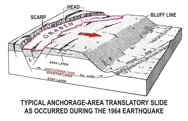
The diagram below illustrates a simplified view of the soil
structure found at the three slide sites, with Naptowne soils
deposited over Bootlegger Cove Formation soils. The upper and lower
layers of the Bootlegger Cove Formation are stiff and competent
soils under most conditions, but the middle layer tends to be
weaker and less cohesive under extreme stress and shaking. This is
the soil layer which experienced liquefaction of its elements,
allowing blocks of soil above it to slide away to lower ground.
Note the graben formed by subsiding wedges of soil which sink down
in height as blocks of soil below them move away from the head of
the slide. The weight of the graben behind the sliding block adds
more pressure for movement once the weak layer of soil has failed,
adding impetus to the movement away from the head of the slide. As
the blocks of soil move, more graben may form as the blocks crack
and separate into smaller blocks. When the foot of the bluff is
excavated or removed (undercutting), support for the block of soil
behind the bluff line is decreased, which increases the likelihood
of a translatory slide.
Terms to understand:
Liquefaction describes a soil’s failure to remain
cohesive and strong during a period of stress while it contains a
large volume of water. Under too much stress the soil cohesion
fails and it behaves like a fluid.
Graben is the name for the sunken section of land created
behind the soil blocks moving along in the slide. Several graben
can be formed in a slide zone, and they are generally perpendicular
in alignment to the movement of the soils.
Horst is the name used for large blocks of soil which have
remained intact and upright in between graben features.
They’re more common in simple slides, and less common in more
complex slide sites.
Head of slide Scarp is a term describing the
uppermost point of the area of slide movement (the head), which is
visible after the slide as being at the top of a Scarp (soil
embankment or sheer bluff).
Undercutting is the term used to describe the removal of
soils or structure at the toe of a bluff. This action can
significantly reduce soil resistance to slide triggers, making
landslides more likely.
Thank you for your interest in learning about the geologic
consequences of the 1964 Alaska earthquake here at Government
Hill.
Resources used to develop this EarthCache:
Effects of the Earthquake Of March 27, 1964 at Anchorage,
Alaska
By Wallace R. Hansen
U.S. Geological Survey Professional Paper 542-A
A Guide To The Geology Of Anchorage:
A Commentary On The Geotechnical And Historical Aspects Of Selected
Localities In The City
By R.G. Updike, C.A. Ulery, and J.L. Weir
Alaska Division of Geological and Geophysical Surveys, June
1986
Pictures (unless otherwise noted) are in the public domain, from
the archives of the U.S. Geological Survey.
Additional Hints
(Decrypt)
Fghql cubgbf naq qrfpevcgvba pnershyyl.
Treasures
You'll collect a digital Treasure from one of these collections when you find and log this geocache:

Loading Treasures