 Salpeterkop as
seen from the north (the opposite side from where you will be) with
Springbok grazing on the grounds of the
Observatory.
Salpeterkop as
seen from the north (the opposite side from where you will be) with
Springbok grazing on the grounds of the
Observatory.
Salpeterkop (Saltpetre Hill) was an active surface volcano about
66 million years ago – believed to be the last one in South
Africa, making it the youngest known active volcano in Africa south
of the Equator. The volcano pushed through the sedimentary layers
during the late Cretaceous period, which is later than the Jurassic
dolerite intrusions common around this area (the focus of my nearby
RockStars EarthCache).
A study, done in 1988 by W.J. Verwoerd of the Geology
Department, University of Stellenbosch found that Salpeterkop forms
part of a dome with radial fractures extending to a distance of at
least 16 km. Four concentric zones of decreasing megascopic
deformation were distinguished, including a central crater 1 km in
diameter, but no unequivocal shock features could be found. The
Salpeterkop structure is interpreted as a dome overlying an
alkaline-carbonatite ring complex, obscured by a volcanic
superstructure that has been only partly eroded.
 Salpeterkop on a
geological map, where:
Salpeterkop on a
geological map, where:
Ksa=Agglomerate, tuff, breccia
Kst=Trachyte
Ksm=Melilite basalt
Ksk=Carbonatite
Jd=Dolerite
When viewing this structure today, it must be remembered that
about 2 km of rock has been eroded away, so we are looking at a
level deep in the throat of the volcano. Its present summit is
reached via a kilometre-wide lava ash field. When climbing it (for
which permission is needed) you cannot help to be intrigued by the
striking circular strata and caves where walls are stained orange,
yellow, red and black from volcanic sulphur elements – quite
obvious where the name originated.
 A close-up view of
the rocks of Salpeterkop shows various colours and evidence of
their heated past.
A close-up view of
the rocks of Salpeterkop shows various colours and evidence of
their heated past.
Pictures: dr. Steve Potter
There are natural caves around Salpeterkop with evidence of
former occupancy by Khoisan people, but are also sites of
significant fossil finds such as the remains of lions, eland and
the extinct brown hyena. More recent human exploration activities
are visible as horizontal shafts dug into the side of the mountain.
More modern drilling activity is also evident when a series of some
75 prospecting boreholes were sunk in and around Salpeterkop during
the 1960s. An intensive study was made by the University of Cape
town in the early 1970s. They found traces of 77 minerals, mainly
Carbonatites, trachytes and olivine melilitites, but only one,
Barite, was worth exploring.

The light-grey area indicates the mineralised zone
– where any minerals of any potential value were
found.
For an area once vigorously shaken by explosive eruptions, it is
today regarded as one of the most seismographically quiet in the
world, enabling a world-class Observatory to be built nearby.
To claim "Found it" you must email me satisfactory responses to
the following:
Any logs not accompanied by an email will be deleted.
- OPTIONAL: Send me a picture of you
and/or your navigation device, taken from the designated position
with Salpeterkop in the background.
- Have a careful look to see if you can spot any signs of a
crater visible at the summit of Salpeterkop. In your own words,
explain what you see, but most importantly, why it is this
way?
- If you go on a night tour
at the nearby Observatory you are likely to see people measure
angles on the sky, using their hands, held at arm’s length,
like in the picture below. Using this same technique, you must
estimate the angle Ang of the summit above the true
horizontal – remember to keep your arm straight and level
with your eyes.
Is Ang closer to 4°, 10° or 20°?
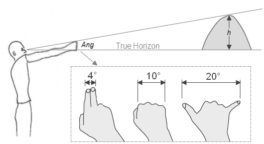
- Given that the summit is 4 km away from here, using simple
trigonometry, it is now easy to calculate its height
(h) using the formula: h = tan (Ang) x 4000m
What is h?
- Finally, the height of the summit above sea level can now be
determined by taking an altitude reading on your GPS (let's call it
Alt) and add it to h.
What do you get for Alt and Alt + h =
?
Note: Do not post any spoiler
pictures or hints to this page, even if
encrypted.