This site is considered SACRED, so please STAY ON THE MARKED TRAIL!!!
Leave the Area as You Found it!
REQUIREMENTS and things to consider before and while attempting this earthcache.
- Summit is CLOSED from 8pm to 5am.
- A 4X4 vehicle is REQUIRED.
- Use low gear going up and coming down, Do Not Over Heat Your Brakes.
- Stopping or parking alongside the road is NOT allowed.
- Park only in designated areas located off the road.
- A One-Hour acclimation to the altitude is highly recommended at the Visitor Center.
- It is NOT recommended that children under the age of 16 traverse to the summit.
- NO camping is allowed.
- NO walking or hiking unless on a trail is allowed (the summit cinder cones are considered sacred as well as habitat for the wekiu bug which is a candidate for federal protection).
- There is now a sign at the beginning of the trail to the summit that asks for your respect. If you feel uncomfortable going past it you may mention that in your log and try your best to get the necessary info from the parking area.
- Please DO NOT sit or stand on the summit ahu (a.k.a. cultural altar). It may look like a UPR (Unnatural Pile of Rocks), but it is SACRED to me and other native Hawaiians!!!
- Schedule enough time to finish the cache requirements by sunset.
- Wear warm clothing.
- Use sunscreen.
- Drink plenty of Water.
- Bring a camera
 !
!
To get credit for this earthcache you have to perform the following tasks.
- Email with the text "GC2Y6MA Maunakea" on the first line.
- Include the Date, Time, and Number of people in your group during your visit.
- While on your careful drive up to the summit, pay attention to the lava in the area (especially along the gravel road portion). What percentage is pahoehoe and 'a'a? ~~~And Remember: DO NOT stop or park alongside the road; park only in designated parking areas located off the roadway.~~~ Email, DO NOT POST the information you gather.
- At the posted coords look North and count the amount of cinder cones visible, estimate the height of the largest one, and tell me where it is located (e.g. ______ from right/left or at XXX degrees). Email, DO NOT POST the information you gather.
- Also at the posted coords look South toward Mauna Loa. What are the main differences between Mauna Kea and Mauna Loa? (Hint: Mauna Loa is younger) Email, DO NOT POST the information you gather.
- Optional: If you so desire take a photo of either you or your GPSr at the posted coords being careful not to include all the cinder cones.
|
Maunakea
The Land of Fire and Ice
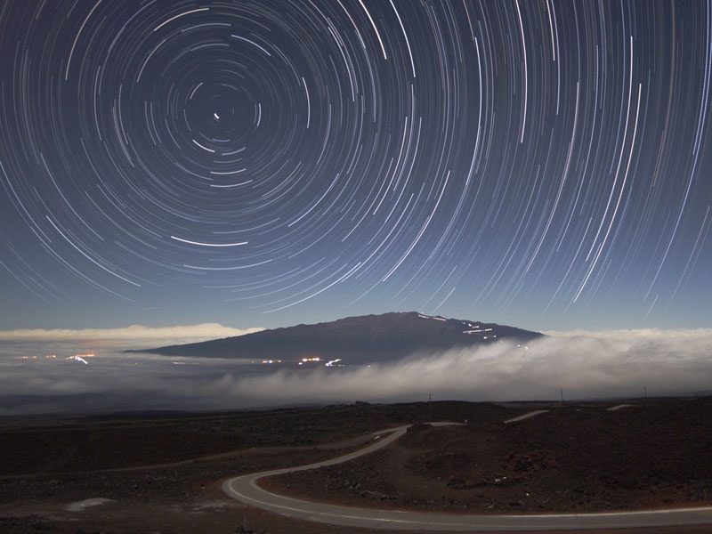 Star Trails Above Maunakea - Credit & Copyright: Peter Michaud (Gemini Observatory), AURA, NSF
Maunakea is a Volcano on the island of Hawai'i. Standing 4,205 m (13,796 ft) above sea level, its peak is the highest point in the state of Hawai'i. However, much of the mountain is under water; when measured from its oceanic base, Maunakea is over 10,000 m (33,000 ft) tall - significantly taller than Mount Everest on the Tibetan Plateau.
In Hawaiian mythology, the peaks of the island of Hawai'i are sacred, and Maunakea is the most sacred of all. An ancient law allowed only high-ranking Ali'i or tribal chiefs to visit its peak. Ancient Hawaiians living on the slopes of Maunakea relied on its extensive forests for food, and quarried the dense volcano-glacial basalts on its flanks for tool production. When Europeans arrived in the late 18th century, settlers introduced cattle, sheep and game animals, many of which became feral and began to damage the mountain's ecology. Maunakea can be ecologically divided into three sections: an alpine climate at its summit, a Sophora chrysophylla - Myoporum sandwicense (or mamane - naio) forest on its flanks, and an Acacia koa - Metrosideros polymorpha (or koa - 'ohi'a) forest, now mostly cleared by the former sugar industry, at its base.
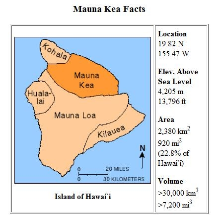 photo credit
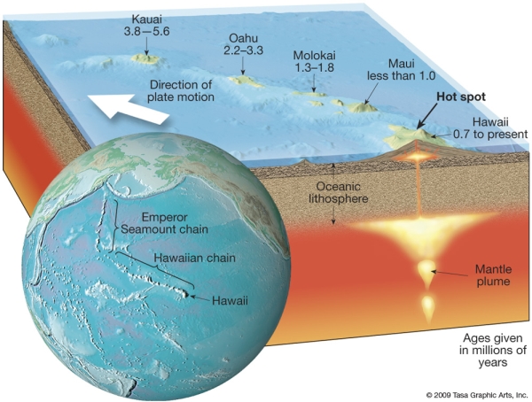
Maunakea is one of five hotspot volcanoes that form the island of Hawai'i, the largest and youngest island of the Hawaiian-Emperor seamount chain. Of these five volcanoes, Maunakea is the fourth oldest and fourth most active. It began as a preshield volcano driven by the Hawai'i hotspot around one million years ago, and became exceptionally active during its shield stage until 500,000 years ago. Maunakea entered its quieter post-shield stage 250,000 to 200,000 years ago, and is currently dormant.
Maunakea is over 3,200 km3 (770 cu mi) in volume, so massive that it and its neighbor, Maunaloa, depress the ocean crust beneath it by 6 km (4 mi). The volcano continues to slip and flatten under its own weight at a rate of less than 0.2 mm (0.01 in) per year. Much of its mass lies east of its present summit.
Lava flows from Maunakea overlapped in complex layers with those of its neighbors during its growth. Most prominently, Maunakea is built upon older flows from Kohala to the northwest, and intersects the base of Maunaloa to the south. The original eruptive fissures (rift zones) in the flanks of Maunakea were buried by its post-shield volcanism. Hilo Ridge, a prominent underwater rift zone structure east of Maunakea, was once believed to be a part of the volcano; however, it is now understood to be a rift zone of Kohala that has been affected by younger Maunakea flows.
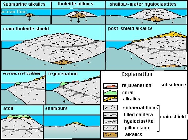 The diagram is adapted from Peterson & Moore (1987)
The shield-stage lavas that built the enormous main mass of the mountain are tholeiitic basalts, like those of Maunaloa, created through the mixing of primary magma and subducted oceanic crust. They are covered by the oldest exposed rock strata on Maunakea, the post-shield alkali basalts of the Hamakua Volcanics, which erupted between 250,000 and 70–65,000 years ago. The most recent volcanic flows are hawaiites and mugearites: they are the post-shield Laupahoehoe Volcanics, erupted between 65,000 and 4,000 years ago. These changes in lava composition accompanied the slow reduction of the supply of magma to the summit, which led to weaker eruptions that then gave way to isolated episodes associated with volcanic dormancy. The Laupahoehoe lavas are more viscous and contain more volatiles than the earlier tholeiitic basalts; their thicker flows significantly steepened Maunakea's flanks. In addition, explosive eruptions have built cinder cones near the summit. These cones are the most recent eruptive centers of Maunakea. Its present summit is dominated by lava domes and cinder cones up to 1.5 km (0.9 mi) in diameter and hundreds of meters tall.
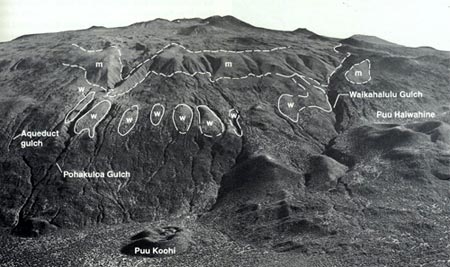 Aerial View of Maunakea from the Saddle Road side.
Areas outlined in white are terminal moraines (m) and glacial till (w).
photo credit
Aerial View of Maunakea from the Saddle Road side.
Areas outlined in white are terminal moraines (m) and glacial till (w).
photo credit
Maunakea is the only Hawaiian volcano with distinct evidence of glaciation. Similar deposits probably existed on Maunaloa, but have been covered by later lava flows. Despite Hawai'i's tropical location, during several past ice ages a drop of only a degree in temperature allowed snow to remain at the mountain's summit through summer, triggering the formation of an ice cap. There are three episodes of glaciation that have been recorded from the last 180,000 years: the Pohakuloa (180 - 130 ka), Waihu (80 - 60 ka) and Makanaka (40 - 13 ka) series. These have extensively sculpted the summit, depositing moraines and a circular ring of till and gravel along the mountain's upper flanks. Subglacial eruptions built cinder cones during the Makanaka glaciation, most of which were heavily gouged by glacial action. The most recent cones were built between 9000 and 4500 years ago, atop the glacial deposits, although one study indicates that the last eruption may have been around 3600 years ago.
At their maximum extent, the glaciers extended from the summit down to between 3,200 and 3,800 m (10,500 and 12,500 ft) of elevation. A small body of permafrost, less than 25 m (80 ft) across, was found at the summit of Maunakea prior to 1974, and may still be present. Small gullies etch the summit, formed by rain- and snow-fed streams that flow only during winter melt and rain showers. On the windward side of the mountain, stream erosion driven by trade winds has accelerated erosion in a manner similar to that on older Kohala.
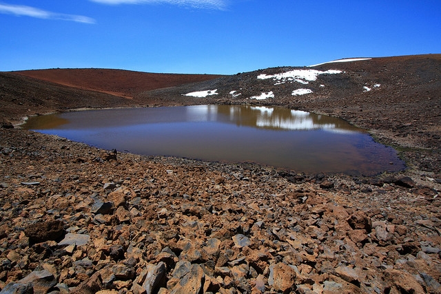 Lake Waiau by Alan Cressler
Maunakea is home to Lake Waiau, the highest lake in the Pacific Basin. At an altitude of 3,969 m (13,022 ft), it lies within the Pu'u Waiau cinder cone and is the only alpine lake in Hawai'i. The lake is very small and shallow, with a surface area of 0.73 ha (1.80 acres) and a depth of 3 m (10 ft). Radiocarbon dating of samples at the base of the lake indicates that it was clear of ice 12,600 years ago. Hawaiian lavas are typically permeable, preventing the formation of lakes due to infiltration. Here, either sulfur-bearing steam altered the volcanic ash to low-permeability clays, or explosive interactions between rising magma and groundwater or surface water (phreatic eruptions) formed exceptionally fine ash that also would reduce the permeability of the lake bed.
The last eruption of Maunakea was about 4,600 years ago; because of this inactivity, Maunakea is assigned a United States Geological Survey hazard listing of 7 for its summit and 8 for its lower flanks, out of the lowest possible hazard rating of 9 (which is given to the extinct volcano Kohala). Twenty percent of the volcano's summit has seen lava flows in the past 10,000 years, and its flanks have seen virtually no lava flows during that time.
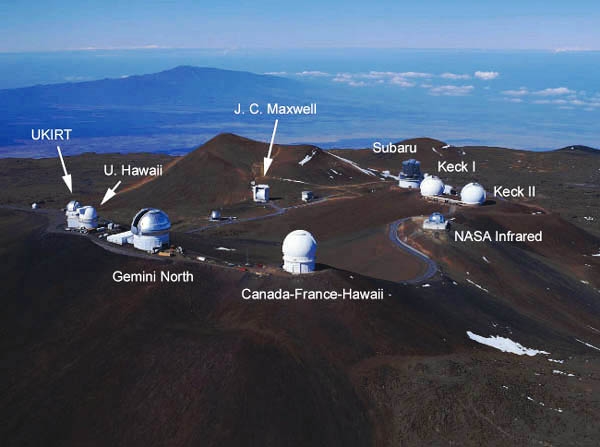 Observatories on Maunakea - photo credit
Despite its dormancy, Maunakea is expected to erupt again, although there would be sufficient warning to evacuate. The telescopes on Maunakea's summit would be the first to detect the minute amounts of deformation resulting from the volcano's swelling, acting like expensive tiltmeters. Based on previous eruptions, such an event could occur anywhere on the volcano's upper flanks and would likely produce extended lava flows, mostly of 'a'a, of 15 - 25 km (9 - 16 mi) in length. Long periods of activity could build a cinder cone at the source. Although not likely in the next few centuries, such an eruption would probably result in little loss of life but significant damage to infrastructure.
References:
- Watson, Jim (5 May 1999). "The long trail of the Hawaiian hotspot". United States Geological Survey.
- "Mauna Kea: Hawai`i's Tallest Volcano". Hawaiian Volcano Observatory - United States Geological Survey. 22 May 2002.
- Blichert-Toft, J.; Weis, D.; Maerschalk, C.; Agranier, A.; and Albarède, F. (19 February 2003). "Hawaiian hotspot dynamics as inferred from Hf and Pb isotope evolution of Mauna Kea volcano". Geochemistry Geophysics Geosystems (American Geophysical Union)
- "Complete Report for Mauna Kea Volcano (Class B) No. 2601". United States Geological Survey. 26 October 2009.
- Wolfe, E.W.; Wise, W.S., and Dalrymple, G.B. (1997). The geology and petrology of Mauna Kea volcano, Hawaii : a study of postshield volcanism. Professional Paper 1557. United States Geological Survey
- Sherrod, David R.; Sinton, John M.; Watkins, Sarah E.; Brunt, Kelly M. (2007). "Geological Map of the State of Hawaii" Open File report 2007-1089. United States Geological Survey. pp. 44 - 48.
- "What in the world is the Hilo Ridge?". Hawaii Volcano Observatory - United States Geological Survey. 8 January 1998.
- Herzberg, Claude (30 November 2006). "Petrology and thermal structure of the Hawaiian plume from Mauna Kea volcano". Nature (Nature Publishing Group) 444 (7119): 605–9.
- Frey, F.A.; Garcia, M. O.; Wise, W. S.; Kennedy, A.; Gurriet, P. and Albarede, F. (1991). "The Evolution of Mauna Kea Volcano, Hawaii: Petrogenesis of Tholeiitic and Alkalic Basalts". Journal of Geophysical Research 96 (B9): 14,347.
- Hon, Ken. "GEOL205 – Fire and Ice – Mauna Kea: Lecture Notes". University of Hawaii at Hilo.
- "Hawaiian Volcano Observatory: Photo Information". Photo description. United States Geological Survey. 13 March 1998.
- Porter, Stephen C. (23 April 1971). "Holocene Eruptions of Mauna Kea Volcano, Hawaii". Science (American Association for the Advancement of Science) 172 (3981): 375–77.
- Porter, Stephen C. (June 1973). "Stratigraphy and Chronology of Late Quaternary Tephra along the South Rift Zone of Mauna Kea Volcano, Hawaii". Geological Society of America Bulletin (Geological Society of America) 84 (6): 1923–40.
- Gregory, Herbert Ernest; Wentworth, Chester Keeler (December 1937). "General features and glacial geology of Mauna Kea, Hawaii". GSA Bulletin (Geological Society of America) 47 (12): 1719 - 42.
- "Hawai'i: Hawai'i's Comprehensive Wildlife Conservation Strategy". Hawaii Department of Land and Natural Resources. 1 October 2005.
- "Mauna Kea Comprehensive Management Plan: UH Management Areas". Institute for Astronomy – University of Hawaii. January 2009.
- Stearns, Harold Thornton; Macdonald, Gordon Andrew (1946). Geology and ground-water resources of the island of Hawaii. Bulletin. 9. United State Geological Survey. p. 245.
- "Impermeable beds trap rain and snow at Mauna Kea's Lake Waiau". Hawaii Volcano Observatory – United States Geological Survey. 19 June 2003.
- Watson, John (18 July 1997). "Lava Flow Hazard Maps: Kohala and Mauna Kea". United States Geological Survey. Retrieved 9 August 2010.
- "The next eruption of Mauna Kea". Hawaii Volcano Observatory – United States Geological Survey. 5 June 2000.
Disclaimer: You are under no obligation to hunt this cache. You do so at your own risk. Like any outdoor sport/activity, it carries the risk of unforeseen hazards. Use your best judgment with the environment and conditions. As conditions and cache locations may vary, it is the responsibility of the searcher to be familiar with the conditions in the area to be searched, to adequately prepare for those conditions, and to conduct oneself safely and responsibly and remain within his or her personal abilities and limitations. Children should be well supervised. Individual Geostash and GPS cache sponsors assume no liability for events, which may occur, related directly or indirectly to your searching for a stash.
 Cache with Al
 ha
ha