This is a letterbox that we have been wanting to place for some time. The posted Waypoint marks where in 1819, Michigan Governor Lewis Cass set out on an exploration of the Michigan territory to disprove land surveyors claims that this territory was swampy and uninhabitable. They reached a desirable area of higher ground here of what is now the intersections of Niles Road (Main), Paint Creek Trail (Rochester) and Ball Line Road (Crooks). They encountered a stately oak tree with a trunk considerably wider than most other oaks. Its large branches reminded Cass of the legend of The Royal Oak Tree, under which King Charles II of England took sanctuary from enemy forces in 1660. Cass and his companions christened the tree, "The Royal Oak".
This is where the City got its name and where your journey to meet the pioneers begins. Some of these people will give you clues to get you to the projection final of this letterbox. Be sure to listen to the pioneers carefully to get the right information.
The posted coordinates take you to where a Bronze plaque used to be. It is the spot the "The Royal Oak Tree" stood. The boulder here was taken from one of the city's farms.
You need to cross Paint Creek Trail to get to the St. Mary's cemetery entrance. It is at the junction of the Triangle Intersection of the roads.
In 1826 Daniel Burrows donated this land for use as a cemetery for Royal Oak. Your journey begins in what was once all Royal Oak Township Cemetery. In 1874, these two acres were sold to the Catholic Society of St. Mary's Parish and is called St. Mary Cemetery.
Heading north on the path, on your right, is two of the people you will meet today. They are the Fraquelli brothers. This is a beautiful marker that is easy to spot. They ran the Royal Oak Monumental Works Company. Many of the headstones you will see today are of their works.
Continuing north and a couple of rows east, you will meet the McHale sisters. This is a great headstone with wonderfully preserved photos of the girls. They were unfortunately killed in an automobile accident. They are the Great grand-daughters of someone else you will be meeting today. They tell you to PLEASE remember them as you will need something about them later today.
Next you will be looking for Mr. Grainger. You will know you are in the correct spot here as he is resting across the path from the M.B. mausoleum. Adolphus' contribution was that of a sawmill. His mill turned out the lumber for the first Belle Isle Bridge.
Mr. Grainger tells you that you will need make note of the 3rd number in his birth year.
Next you will meet Edmund Loughnane. You know are in the correct spot as his name plate is almost on the path, the monument stands a few feet back. He was one of the first people buried in Saint Marys cemetery. He donated 1/4 acre at Twelve Mile and Campbell Road for the First Catholic Church. Services were held once a month by a priest from Centerline for this parish of 25 members, mostly of German and French origin. He is the Great-grandfather of the McHale girls.
Heading north on the path, on you left you will see the statue of the Blessed Mother Mary. It sat atop of the St. Mary's church high school in 1925 and was moved here in 1992.
Continuing north along the path, on the east side, you will meet one of the most prosperous and widely known residents, Welcome Campbell.

He was a cooper (maker of wood casks, barrels, buckets) and a farmer. In 1859, Mr. Campbell with his wife and eight children ( 5 boys & 5 girls) moved to Royal Oak Township where he bought 750 acres of land between 9 and 10 Mile, which had a road running north through it. He built his home on what is now know as Campbell Road in Royal Oak.

The house was torn down in 1978 after many years of neglect.
Welcome tells you that for a number you need, face his marker and count the number of large (at least 3' tall, upright) monuments in this row that use his name.
Heading somewhat northwest, between two trees with large burls on them, you are stopping to see the "One Eyed Sheriff." Alexander Lewless' marker is a tall gray stone. He was the only deputy sheriff for more than 40 years here.
Continuing due north and 1 row east, you are looking for Charles Allen. You will know you are close when you spot his relatives tall marker with the name of a state on it. His is a flat on the ground marker, next to his wife. He is called "Father of Royal Oak" as he single handedly circulated the petitions to have Royal Oak incorporated back in 1891.
Moving back onto the path and continuing north is a very large stone marker with the name Parker. Asher Parker invented the "Michigan Plow". It was a small plow used to precede the larger one to break up the prairie sod. He was the grandson of someone you will soon be meeting.
Ashton tells you to note the 3rd number in his death date.
Moving north and back onto the path, looking to the east, you will meet the man who built the only water mill in this town. James Johnson's marker states - "He served his generation." It was said that during the spring water run-off, his mill could cut 2000 feet of lumber in 24 hours.
Traveling north again down the path, just before it starts to turn to the right, on the left side of the path you are going to meet one of the more famous people who settled in Royal Oak. There is his original headstone along with a dedicated boulder marker at his grave. Erza Parker fought in the Revolutionary War at Lexington and the Battle of Bunker Hill. He was an orderly with Benedict Arnold and was with him on the Plains of Abraham. He also served under General Stark. His homestead stood at 13 mile and Woodward until 1953 when the Northwood Shopping Center was built.
Moving north and 2 rows west, you will meet a lady who is the oldest burial in the Royal Oak Cemetery. She died when she was only ?7 years old. Harriet Goodwin was the daughter of Cromwell Goodwin, the first bricklayer of the town. She lies 2 plots south of her father. Harriet tells you that you need to know the missing number in her age at time of her death. It is marked on her stone.
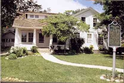
Continuing east 4 rows and then north towards the fence, you will meet the famous cow bell maker, Orson Starr.

His bells were the beginning industry of Royal Oak. These bells are now prized by collectors. He purchased an 80 - acre tract of land for $160 and built his home at 13 mile and Main street in 1845. His home still stands at that site.
Standing at Orson Starr's marker, with the information these pioneers shared with you, use it to project(true north) to the future to find the letterbox.
You need for the degrees to use:
The 3rd number in Mr. Graingers birth year.
Harriet Goodwin's missing number of her age at death.
From Welcome Campbell, the number of large monuments in the row.
for the feet use:
The number of sisters you met today.
The 3rd number in Asher Parkers death date.
The number of letters in the name of the City you are standing in
PLEASE DO NOT TAKE THE LETTERBOX STAMP
Be sure to stamp your journal with the unique stamp and if you have
your own stamp, please imprint it into our logbook/journal.