L&A Yarker Falls Erosion and
Abrasion
Earth Cache
As you stand on the bridge at ground zero, allow me to take
you
back in time.
Hundreds or years ago, you would be standing in
the middle or the raging Napanee River.
Very wide and very deep.
The river would be heading straight and 50-60 meters down stream
is
would make a slight left bend.
So how do you go from a
fairly straight raging river to the Falls we see today?
Allow me to explain these few simple steps.
Yes simple, but over a very long time.
The falls and the bend were caused by types of Erosion and
Abrasion
Lesson
What is erosion and abrasion, and how does it work?
Using the following information and what you see at GZ
answer the following 4 questions.
(1) How many steps, can you see in the Yarker Falls?
(2) Looking down the River to the Left turn, estimate how high the
river used to be.
(3) Name 2 signs of continuing erosion, that you see
(4) Take an altitude reading with your GPS or Guess the total
drop in the River from GZ to where the
river turns Left.
E-mail the answers to me through my Geocaching profile.
As I have many Earth caches, please place "Yarker Falls" in the
subject line.
Although pictures are totally
voluntary,
I encourage you to post some, with the date taken,
so everyone can see how the falls change over the
year.
*****************************************************************************
Waterfalls are sheer vertical
falls in the channel of a river. Examples of a well
known
waterfalls is the Niagra Falls in
USA/Canada.
Waterfalls are found in the
upper course
of a river.
Typically waterfalls occur where
ariver
flows across a band of hard rock onto a band of
softer rock, Soil and debris.
The
waterfall is created because of
differential
erosion, that
is, different rates of
erosion.
As the river flows downstream the
softer rock is
eroded more quickly as a result of the processes
of abrasion
and hydraulic
action.
The river carries a bed load of stones and pebbles.
Asthe river flows, the bed load strikes the
bed and banks
of the river causing the channel
toerode.
This process is called abrasion.
Hydraulic action is erosion caused by the
sheerforce of flowing water.
Water rushes into cavities or small cracks in the river
channeland forces soil and
rock particles away from the river channel or banks.
Where the Napanee River turned left below the Yarker
Falls, the Erosion process caused the turn to become deeper and
sharper.
In a waterfall, erosion is
concentrated downwards into the bed of
the channel. This
aspect of the process is
called vertical
erosion
and
causes the river channel to
deepen.
As the
river passes the hard rock a knick
point develops on the soft rock. Here the
river water can become ‘broken’ by
the development of rapids.
This effect produces ‘whitewater’
because the water
is turbulent here. Over a long period of time the soft rock
will erode producing a
vertical
drop in the
river channel. This is the waterfall.
The energy of the falling water will continue to
erode the bed of
the river so that eventually a plunge
pool
will develop at the base of the
waterfall.
The plunge pool develops initially
becausethe force of the falling water creates a
slightly deeper
pool in the bed of the river. As
therivers’ bed load falls into the pool
it swirls about
frantically and scours the base of
thepool causing it to deepen. This is what we
see at the
Yarker Falls, where it takes it's left turn.
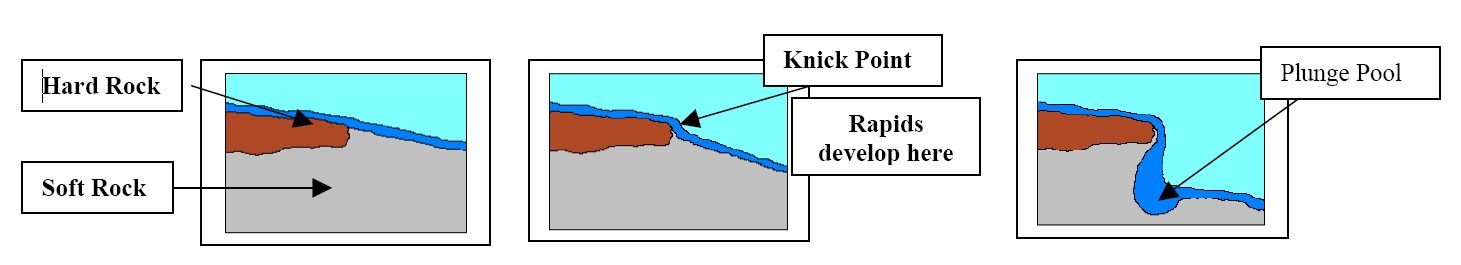
Over a longer period of time, perhaps hundreds of years, the plunge
pool will grow
largerand assist the river in eroding backwards.
This backward erosion is
called headwarderosion.
Eventually the band of hard rock above the plunge pool will be
undermined.
Without
the support of the rock below, the band of hard
rock will collapse into the
river.
Over a
still longer period of time, the river will erode
back through its bed and produce
agorge.
A gorge is a valley with vertical walls at the bottom of which lies
the riverwhich eroded it.
*****************************************************************************
So over the course of hundreds of years, the Napanee River started
to have abrasion and hydraulic
action.
This caused the river here to deepen, as time continued on the
Erosion started to focus
downward
causing a small sets of waterfalls to develop. This process
continued several times causing "Steps" in the Falls
As this mighty Napanee river continued to flow onward and
downward, the soft rock, dirt and debris
eroded away, causing multiple Knick Points, eventually breaking off
and causing larger "Steps" to develop
Over the years the flow rate and amount of water in the river has
lessened and this is what
Yarker Falls looks like today.
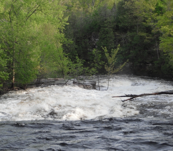
So, has the Erosion and Abrasion process stopped?
No ! But is has slowed a lot.
Most of the falls and Napanee river in this area have a
limestone
(CaCO3) base.
So the vertical erosion has almost stopped, but erosion and
abrasion still continues on the
sides of the falls and river edges.
During the spring and heavy rain periods, the
falls and river swell to higher then normal levels, and this causes
widening of the edges.
During dryer times you can see where the river is making it's way
in and around
tree roots, and limestone ledges and cracks, eroding away the soil
and smaller rocks
creating bigger ledges and gaps in the limestone layers.
End of Lesson.
This Earth Cache is being paced for the L&A
Geocaching Event, Please do not hunt it until
9am August 27, 2011