Roll Tide EarthCache
Please note Use of geocaching.com services is subject to the terms and conditions
in our disclaimer.
Tides. They are among some of the most interesting phenomena on our earth. While they are something that we all have a general idea about, or learned about in grade school science class, let's take this opportunity to delve a little deeper into the subject and refresh our memory of how and why tides work and why they are important to us and our earth.
About a year and half ago, just a few miles from here, I found my very first Earthcache ('Earthcache at Gulf State Park' - GC1NBF5), and my love of this type of cache began. This is the 3rd earthcache that I have developed that put up to the EC Masters Platinum level; and it was published just as I found my 40th Earthcache (Green Mountain Sandstone Outcropping - GC1F0AA) - I hope you enjoy it!
Ok, ok, enough about stuff you don't want to know, on to the earth science!
For this cache you must visit the location at the posted coordinates and make several observations as listed below. The posted coords will take you to a public beach access in Gulf Shores, along the emerald coast along the Gulf of Mexico.
An ocean tide refers to the cyclic rise and fall of seawater. Tides are caused by slight variations in gravitational attraction between the Earth and the moon and the Sun in geometric relationship with locations on the Earth's surface. Tides are periodic primarily because of the cyclical influence of the Earth's rotation.
The Sun and Moon pull on the Earth, the water, even you! But gravitational attraction depends on distance and mass. For example, you have very little mass and you're very close to the Earth, so the Sun and Moon can't just yank you off the planet. The Sun is extremely massive, but it is an average of 93 million miles (150 million km) from Earth, compared with about 238,866 miles (384,400 km) from here to the Moon. And since the Moon is nearly 400 times closer to our planet, its influence on our oceans is twice as strong as the Sun's.
The moon is the primary factor controlling the temporal rhythm and height of tides. The moon produces two tidal bulges somewhere on the Earth through the effects of gravitational attraction. The height of these tidal bulges is controlled by the moon's gravitational force and the Earth's gravity pulling the water back toward the Earth. At the location on the Earth closest to the moon, seawater is drawn toward the moon because of the greater strength of gravitational attraction. On the opposite side of the Earth, another tidal bulge is produced away from the moon. However, this bulge is due to the fact that at this point on the Earth the force of the moon's gravity is at its weakest. Considering this information, any given point on the Earth's surface should experience two tidal crests and two tidal troughs during each tidal period.
The timing of tidal events is related to the Earth's rotation and the revolution of the moon around the Earth. If the moon was stationary in space, the tidal cycle would be 24 hours long. However, the moon is in motion revolving around the Earth. One revolution takes about 27 days and adds about 50 minutes to the tidal cycle. As a result, the tidal period is 24 hours and 50 minutes in length. The lunar day is longer than the Earth day because the Moon orbits in the same direction the Earth spins. This is analogous to the minute hand on a watch crossing the hour hand at 12:00 and then again at about 1:05 (not at 1:00) because the hour hand is moving in that direction as well.
The second factor controlling tides on the Earth's surface is the Sun's gravity. The height of the average solar tide is about 50% the average lunar tide. At certain times during the moon's revolution around the Earth, the direction of its gravitational attraction is aligned with the Sun's. During these times the two tide producing bodies act together to create the highest and lowest tides of the year. This planetary allignment of the sun, earth, and moon is called Syzygy (siz-eh-gee). These spring tides occur every 14-15 days during full and new moons. (See Below)
When the gravitational pull of the moon and Sun are at right angles to each other, the daily tidal variations on the Earth are at their least. These events are called neap tides and they occur during the first and last quarter of the moon. (See Below)
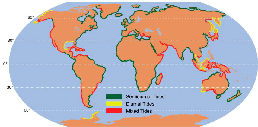
Tides are most commonly semidiurnal (two high waters and two low waters each day), or diurnal (one tidal cycle per day). The two high waters on a given day are typically not the same height (the daily inequality); these are the higher high water and the lower high water in tide tables. Similarly, the two low waters each day are the higher low water and the lower low water. The daily inequality is not consistent and is generally small when the Moon is over the equator.
The map below shows the geographic distribution of these three tide types on the Earth.
Extreme example of high and low tides:
 Visit Link
Tidal Currents and Bores:
Accompanying the vertical rise and fall of water are various horizontal or lateral movements commonly known as tidal currents or tidal streams. When the high tide is moving in, a tidal current known as the flood current flows towards the shore for about six hours. At high tide, the current reverses and flows away from shore. This is the ebb current. At low tide about six hours later, the current reverses again. The exact times may vary depending on local conditions. During the period of reversal, the water is in a state of rest or calm, known as slack water. Like the cyclical tides, these reversing currents are important to seagoing vessels. Ships entering a river’s mouth, heading for an upstream port, receive a boost from a flood current.
When a large volume of water from a flood current accumulates in the mouth of a funnel-shaped river or estuary more rapidly than it can flow upstream, a crested wave, or bore, gradually forms and rushes up the channel. The highest bores in the world reach heights of more than 4.5 metres (15 feet). Notable bores occur at the mouths of the Qiantang Jiang estuary on the Hangzhou Wan in China, of the Petitcodiac River in the Bay of Fundy, of the River Severn of the United Kingdom, and of the Amazon in Brazil. During a spring tide, the Amazon’s bore may travel 650 kilometres (400 miles) upstream at a speed of over 65 kilometres per hour (40 miles per hour).
Tidal Energy:
The energy from tides has been harnessed to produce electricity. In 1966 a tidal power plant with a capacity of 240,000 kilowatts went into operation in northwestern France on the Rance River, an estuary of the English Channel. The incoming tide of the river flows through a dam near the city of Saint-Malo, driving turbines, and then is trapped behind the dam. When the tide ebbs, the trapped water is released and flows back through the dam, again driving the turbines. Such tidal powerplants are most efficient if the difference between high and low tides is great, as in the Rance estuary, where the tidal range is 8.5 metres (28 feet).
So, why are tides Important?
Tides are important to geology because of their ability to transport sediment and carve coastlines. Over a long period, shorelines shift, estuaries and rivers are filled in with sediment, and beaches change from the rise and fall of the tides. This is why there is the constant shifting of the shoreline, and why it has been so difficult for humans to live in these areas where change is constant.
In the world of commerce, tides are vitally important to the shipping and fishing industries. Navigators of heavy freighters heading for shallow ports must schedule their arrival for high tide, when the water is deepest. Fishing boats are also subject to the ebb and flow of tides. Predicting these changes is an essential aspect of maritime travel, and highly detailed tide tables are available for almost all coastal areas.
Tidal flows are of importance in navigation, and significant errors in position will occur if they are not taken into account. Tidal heights are also important; for example many rivers and harbors have a shallow "bar" at the entrance which will prevent boats with significant draft from entering at certain states of the tide.
--------------------------------------------------------
Please email me the answers to the following questions to log your find. These can be answered by a combination of reading the material and information on this cache page and possibly a little extra research on your part and then, most importantly, visiting the coordinates and making your observations of the environment there using the information you've learned about the tides and their effects on the coastal environment.
1) Marine Geology Vocabulary lesson. I learned these terms while creating this earthcache and though they were interesting and that they were relevant to this earthcache.
What do the following terms mean?
a)Bathymetry
b)Littoral zone
c)Spring Tide
d)Neap Tide
e)Semidiurnal Tides
f)Diurnal Tides
2)
a)How do Tides affect how beaches (like the one you are standing on) form over time?
b) What are other geological factors in the formation of beaches over time?
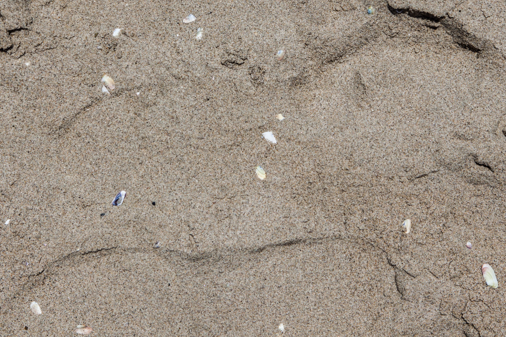
c)Given how they are formed, from the pictures why do you think the fine white sand that your standing in along the gulf of mexico is so different in color and texture when compared to the dark coarser sand from the east coast?
Gulf of Mexico

West Coast
3)
a) Is this area a Semidiurnal Tide Zone, a Diurnal Tide Zone, or a mixed tide and why do you think that is the case (See that Vocab. lesson is already paying off!)?
b)Also, based on the dunes and water line do you think the tide is currently high or low at the coordinates?
c) If the tide is low how wide (in feet) do you think the inter-tidal zone (distance between the high tide line and the low tide line) is at the posted cordinates?
4) We know the Moon is mainly responsible for the tides, explain (Generally and in your own words) why. Are there any other plantery factors that affect the tides?
5) What major event devestated the natural marine ecosystem around this part of the Florida (and Alabama/Louisiana) coastlines on the morning of April 20, 2010? The tides and resulting currents carried this material as far down the coastline as the Florida panhandle from its original location.
6) (Optional, but appreciated) - Please post a picture of you and/or your GPSr at the coordinates to comemorate your visit.
Congrats to Zeek_70706 for the FTF!
Sources:
http://www.pacificislandtravel.com
http://www.wikipedia.org
http://www.physicalgeography.net
http://www.onr.navy.mil
http://www.saltwatertides.com
Additional Hints
(Decrypt)
Choyvp Ornpu Npprff. Vs lbh cnex ng/nebhaq gur Unatbhg gurer vf nccneragyl n $5 cnexvat srr.. Gurer vf bgure serr cnexvat arneol vs lbh fpbhg nebhaq.
Treasures
You'll collect a digital Treasure from one of these collections when you find and log this geocache:

Loading Treasures