In simple terms, a basin is a depression in the
Earth's crust which is usually filled with water for most of it's
existence. The depth of these basins vary and may even be hundreds
of meters deep. Basins are usually fresh water bodies unless they
are linked via tidal areas to the sea. From the surrounding higher
areas streams and rivers drain into the basin. These erode the
surrounding landscape and deposit the eroded materials into the
basin. In time, if no other major geological forces occur these
eventually fill up the basin. This area might form a new
depression, or faulting and shifting may cause other basins to form
which may partly overlap. Most of the sediments preserved in basins
are not formed in their permanently submerged parts, but in
shallower areas of slow moving water. Some sedimentary basins are
not formed by water but by wind. In this case driving winds carry
eroded materials over a depression where they are deposited over
time to form large expanses of sedimentary deposits.
A similar basin such as described in the above paragraphs existed
in this area during the Cambrian to Ordovician period, consisting
of a relatively shallow depression fed by rivers from surrounding
high areas. Until the development of a fault line in this area
resulting in the uplifting of the basin and resulting in erosion
that led to the features visible today.

Cross bedding can help us to understand ancient
water / air current direction. As the water or air current moves
downstream / downwind, it picks up particles of mud or grains of
sand. If they are exposed to the full force of the current, sand
grains are likely to be moved on. However, if they fall into the
"lee" of the ripple, they are no longer under the influence of the
main current. The water / air is calmer there, and the particles
are deposited. The particulate materials accumulate on the steep
slope of the ripple-mark, facing downstream. A succession of these
"ripple fronts" is preserved as a series of cross-beds.
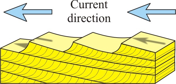
The arrow shown skimming across the top of the
ripples shows the fastest bottom current that carries the
particles. Because ripples advance by erosion off the back and
deposition down the front (the steep side), the tops of ripples are
commonly lost to erosion and the cross-beds preserve only the lower
part of the original ripple. Note that the main horizontal layers
are often very gently inclined. The steep front faces tilt
down-current and thus indicate current flow direction. Cross-beds
are commonly curved at the base. All of this gives a guide to
determining the original orientation of the layers in more complex
bedding examples.
Although the overall layering is horizontal, the
structure can be further modified by periods of stronger water or
wind currents which will erode already deposited layers, resulting
in even horizontal bands. Horizontal Bands may also be deposited in
different directions depending on the current flows at the time of
creation. Large gently sloping cross-beds could indicate that these
sediments were deposited by slow flowing river currents or
deposited on large windswept areas. The grain structure is an
indication of the materials that were deposited from the suspended
source. Larger conglomerate inclusions often indicate a period of
stronger current flow as the largest and heaviest particles in
suspension are deposited and conversely a fine structure may
indicate a slower current. Very fine grain grain structure may also
be an indicator of river-delta conditions, these often producing
mudstone rather than sandstone.

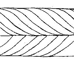
Matched sets of cross-beds tilting in opposite
directions are called herringbone cross-beds. Such beds are most
commonly produced by tidal movements in and out of a shallow
sea.
This site is best approached coming form the bottom of Fields Hill
on the M13 and turning off the highway at S 29° 47.877 E 030°
50.910 and finding a safe parking spot, before walking to the view
site. For a better overall view there is parking available on the
opposite side of the highway from where a general picture can be
obtained.
Please note that you are going to be close to a major highway,
and although you do not need to venture near it, please at all
times be aware of your surroundings and ensure that you are safely
out of the way of any traffic.
Due to the location of the site this cache is not recommended for
small children.