
Nukumoi Point
Tombolo
Po‘ipū Beach
Park, Kaua‘i
On Kaua‘i's sunny southern shore, Po‘ipū Beach
is a favorite tourist destination and in 2001 was named the "Best
Beach in America". The beach features two small bays, separated at
times by a tombolo joining the shoreline to Nukumoi Point, a
small rocky islet just off shore. Often, endangered Hawai‘ian
monk seals can be observed resting on the point.
What is a Tombolo?
A tombolo, from the Italian tombolo, derived from the Latin
tumulus, meaning 'mound,' is a coastal deposition landform in which
an island is connected to the mainland or another island by a
narrow piece of land such as a spit or sand bar. Once attached, the
island is then known as a tied island. 
Ocean Currents Move Sand Around
Beaches are areas of loose sand, gravel and cobbles controlled by
ocean processes. Waves and currents move this sediment - constantly
creating, eroding and changing the coastline. One primary force in
the formation of a beach is called a longshore current.
As an ocean wave moves toward the beach, usually one end reaches
the shore first. This front part of the wave encounters the shallow
water and slows down. As a result, the wave refracts, or
bends and conforms to the general shape of the coastline. The rest
of the wave bends as it comes onto the shore creating a current
that parallels the beach. Longshore currents can carry large
amounts of sand parallel to the shoreline.
The water in this longshore current flows up onto the beach
(swash), and back into the ocean (backwash). As this sheet of water
moves on and off the beach, it carries sand back out to sea. This
process, called longshore drift, can cause significant beach
erosion. At Po‘ipū Beach, erosion is a serious ongoing
concern and "beach nourishment" projects using near shore sand
fields to restore the shoreline are currently being studied.
How a Tombolo is Formed
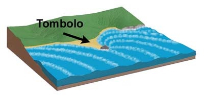 Tombolos are formed by wave refraction. As waves
near an island, they are slowed by the shallow water surrounding
it. These waves then refract or “bend” around the
island to the opposite side as they approach. The wave pattern
created by this water movement causes simultaneous longshore drift
on both sides of the island. In other words, the waves sweep
sediment together from both sides. Eventually, when enough material
has built up, the beach shoreline, known as a spit, will connect
with the island and form a tombolo.
Tombolos are formed by wave refraction. As waves
near an island, they are slowed by the shallow water surrounding
it. These waves then refract or “bend” around the
island to the opposite side as they approach. The wave pattern
created by this water movement causes simultaneous longshore drift
on both sides of the island. In other words, the waves sweep
sediment together from both sides. Eventually, when enough material
has built up, the beach shoreline, known as a spit, will connect
with the island and form a tombolo.

Wave refraction around Nukumoi Point 9/13/2006
source: Google Earth
Tombolos Change Over Time
By observing tombolos, we can understand the sensitivity of
shorelines. Tombolos, like other coastal features, typically change
dramatically over time due to changing sediment supply, currents,
sea levels and storm events. Due to unusual weather conditions in
2010, the Nukumoi Point Tombolo reappeared at Po‘ipū
Beach Park after an absence of approximately ten years.
As you can observe in the following photographs, the Nukumoi
Point tombolo has indeed changed over the course of the past few
years.

Nukumoi Point in 2010

Nukumoi Point on 9/13/2006 source: Google
Earth

Nukumoi Point on 1/5/2004 source: Google
Earth
Logging requirements:
Please remember this is an EarthCache, there is no physical
container to find at the posted coordinates.
The posted coordinates bring you to a point on the shore where
you should be able to safely observe the tombolo. To claim this
earthcache as "Found", send us a note through our profile on
geocaching.com with your answers to the following items:
- The text "GC2ZEWN Nukumoi Point Tombolo" on the first line
- The number of people in your group.
- Based on your observation from the posted coordinates, estimate
of the width and height of the exposed spit between the shore and
the island.
- Date of your visit, time of day and tide height at time of
visit. Link to tide table for the nearest monitoring station is
here.
- On both sides of the spit, observe the wave action (if
exposed), or the longshore current over the spit if it is under
water. Send us your description of how you think this affects the
formation of the spit at the time of your visit.
- Not required but helpful to observe the changes in the tombolo
over time: Post a picture with your online log of you and the
tombolo.
- After sending us the required answers, go ahead and log your
find. Please do not post your answers in your online
log.
Disclaimer: This earthcache does not
require finders to cross the spit to the island. If you do, you do
so at your own risk. Rip currents in this location can be very
strong and dangerous.
Resources:
Geology.com
Wikipedia.org
Geology.about.com
Office of Naval Research; Habitats: Beaches - Characteristics;
http://www.onr.navy.mil/focus/ocean/habitats/beaches1.htm
http://oceanservice.noaa.gov/education/kits/currents/03coastal1.html


 Free counters
