Sanding Room Only EarthCache
-
Difficulty:
-

-
Terrain:
-

Size:  (not chosen)
Please note Use of geocaching.com services is subject to the terms and conditions
in our disclaimer.
The Bluff River Gorge is situated about an hour northeast of Hobart
in the Swansea State Forest. This is a short scenic walk along one
side of the gorge. Although the track is a little overgrown in some
places, it is relatively easy to follow for those with some
bushwalking experience. There are a couple of steep sections. This
is one of a series of 3 caches placed to highlight different
features of the gorge.
To get to the start of the walk you must first travel to Buckland,
then turn off to the north onto the Buckland Road and travel for
approximately 11km. There is a clear boundary between private
property (open paddocks) and the state forest, which crosses the
road in an obvious straight line, where the parking coordinates are
located.
The track starts parallel with the fence line, and after a short
distance you reach a small clearing where there is a fork in the
track and a big tree with an arrow on it. The easier but slightly
longer route is to take the right fork (in the direction of the
arrow). This eventually leads to another small clearing where the
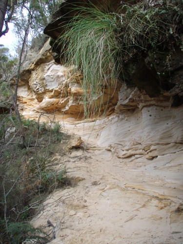
gorge walk proper starts (see photo). You will need to leave the
fire trail at this point and the trail to the gorge is narrow but
defined. Head downhill to another not so obvious fork where the
track branches off either around a tree (to GC2ZFA) or downhill,
which is the way you need to go. Watch out for stinging nettles at
this spot. After approximately 30 m there is another fork; you need
to go straight ahead and make your way across the little creek,
following the tape along the trail. The track ascends on the other
side a short distance to GZ.
The sandstones of central and eastern Tasmania were formed in
Permian and Triassic times (approximately 200-300 million years
ago). The clean quartz sandstones are typical of the early
Triassic; quartz is the dominant material, arising from the
destruction and winnowing of older rock. The sandstone created in
this period was not marine in nature, rather, the sedimentation
occurred on windswept plains during periods of local flooding.
Angular shaped grains of sand occur when there is minimal transport
and tumbling of sand, whereas rounded grains suggest a long period
of transport, tumbling and wearing of the individual grains.
Deposition of sand also happened in dunes, billabongs and rivers.
This created irregular consolidation and compaction of the sand,
producing sandstones of varying quality. The colonial stonemasons
were skilled at selecting the harder sandstone suitable for
building.
In the latter Triassic period the sandstones were gradually
overlaid by mudstone. There are a number of environmental forces
which have shaped this sandstone to what it is today. The course of
the Bluff River, over time, has carved into the softer areas and
inconsistencies of the sandstone that was laid down. Although the
gorge is deep, there are side cuttings in the gorge creating a fern
leaf pattern of drainage. The tougher sandstone has survived in the
form of ridges and cliffs. The remaining sandstone has been openly
exposed to wind and rain, which has scalloped caves out of the
softer sections of rock. There are also subtleties within the caves
- fissures have been grooved deep into some of the softer lines of
stone vertically, and even horizontally in some sections you can
see the clear delineation between harder and softer layers of
sandstone. There are visible round pebbles of harder volcanic rock
in some sections. This often occurred during the later Triassic
period. The colour of sandstone in this area ranges from white to
tan and yellow, indicating varying quantities of the clear quartz
with the amber coloured feldspar of the sand. There is also some
iron oxide in this rock that adds an obvious reddish tint to the
layers.
Claiming the EarthCache This is very straightforward once you have
arrived at the listed coordinates. Observe carefully and answer the
following questions and be sure to take a photo of you (or your
team) at the site.
Approximately how big (in diameter) are the grains of sand at the
bottom of the cave?
What is the approximate thickness of the sandstone shelves (where
softer layers have been eroded) on the right side of the
cave?
What colour are volcanic pebbles?
Send the answers, with a clear identification of the EarthCache,
via the GC profile above and log your found. Logs without the
corresponding correct answers and uploaded photo will be
deleted.
Enjoy the EarthCache!
Additional Hints
(No hints available.)
Treasures
You'll collect a digital Treasure from one of these collections when you find and log this geocache:

Loading Treasures