Pour logger votre visite:
REPONDRE A LA QUESTION OU PRENDRE UNE PHOTO AVEC LA TABLE D'ORIENTATION ET LA METTRE SUR LE "FOUND" ET NON EN MESSAGERIE
(ENVOYER-MOI LA REPONSE A LA QUESTION VIA MON PROFIL,LE FOUND-IT NE SERA ACCEPTE SEULEMENT SI C'EST LA BONNE REPONSE).
Répondre a la question suivante et envoyer les moi par mail sur la page de mon profil, le"found-it" sera accepté si la réponse est bonne
"il y a la présence importante d'une pierre de couleur grise au pieds des montagnes Alpine et qui a servi de semelle lubrifiante entre les plaques d'Europe et d'Afrique,donnée le nom de la pierre?"
HISTOIRE GÉOLOGIQUE DE LA FORMATION DES ALPES
Aujourd'hui, les géologues ont une idée globale du fonctionnement de la planète Terre avec le mécanisme de la tectonique des plaques lithosphériques.
Ainsi, du fait d'une énergie interne, liée en particulier à la présence d'éléments radioactifs qui « chauffent » le cœur de la Terre, à la surface de celle-ci, de grandes plaques rigides de lithosphère (croûte terrestre + enveloppe la plus externe du manteau supérieur) qui en composent la partie la plus périphérique (100 à 150 km d'épaisseur sur les 6370 km de rayon de la planète), se déplacent les unes par rapport aux autres.
Elles s'écartent, se rapprochent, coulissent au gré de courants internes de la partie du manteau supérieur plus souple, sur laquelle elles "flottent" et qui s'étend jusqu'à 670 km de profondeur (asthénosphère).
L'histoire des Alpes n'est autre chose que la reconstitution de déplacements qui ont affecté et qui affectent les plaques Europe et Afrique.
On a pu retrouver les étapes de cette histoire en interrogeant les roches et paysages d'aujourd'hui. En effet, les géologues, en utilisant des méthodes et principes simples propres à leur science, ont retracé l'histoire de nos Alpes… aboutissement de la disparition d'un océan !
Les prémices du mouvement de divergence Il y a 250 millions d'années (au Trias), un immense continent – la Pangée – aplani par l'érosion s'enfonçait peu à peu (subsidence). Dans la mer très peu profonde qui l'inondait se sont déposés des sédiments.
La divergence et l'amincissement du continent Vers 200 millions d'années ( au début du Jurassique), le continent fut affecté de mouvements de divergence avec des déformations en extension, des cassures ou failles normales. Il se découpa en immenses blocs continentaux tout en s'amincissant ce qui créa une vaste dépression rapidement occupée par une mer plus profonde, au sein de laquelle des sédiments se déposaient.
La divergence et l'océanisation Vers 155 millions d'années (Jurassique supérieur), la plaque continentale s'est déchirée, le manteau chaud se mit à fondre en partie pour donner naissance à un fond océanique constitué de roches plus sombres plus denses (basaltes et gabbros) que les roches continentales claires et moins denses (granites, gneiss).
Cet océan comportait deux volets décalés, l'Atlantique central et l'océan alpin.
Des sédiments de grande profondeur recouvrent les fonds océaniques et leurs bordures continentales. Bien sûr la géographie fut bouleversée… exit Pangée, bonjour Europe - Afrique - Amériques !
L'Afrique dérivait vers l'Est par rapport à l'Europe. L'Atlantique central, bientôt relayé par l'Atlantique Sud puis Nord, est toujours « vivant », il continue de grandir au rythme moyen de 2 centimètres par an.
L'océan alpin a disparu…en lieu et place : LES ALPES ! QUE S'EST-IL PASSE ? Le mouvement de convergence des plaques !!!
Après avoir fonctionné de concert avec son grand frère Atlantique Central, entre 155 et 100 millions d'années (crétacé inférieur), l'inversion des mouvements relatifs Europe - Afrique s'est traduite par l'engloutissement de l'océan alpin (subduction) sous l'Afrique ! Pourquoi ? À cause de l'ouverture de l'Atlantique sud ! Il en est résulté une poussée de l'Afrique vers le nord…(consultez votre planisphère !)
Comment cela s'est il déroulé ? Les deux continents Europe et Afrique qui constituaient les bords (marges) de l'océan alpin se déplaçant l'un vers l'autre, l'océan alpin constitué de roches plus denses (2,9), a « plongé » sous le continent Afrique (densité 2,7) et disparu peu à peu, entre 100 et 65 millions d'années (crétacé supérieur). En Queyras, les roches ont gardé la trace de cet événement !
Finalement l'Europe, tractée par l'océan alpin, s'engage sous l'Afrique… mais pour des raisons de densité équivalente, le système se bloque et le continent européen se casse en grandes écailles qui se sous charrient les unes les autres et sous l'Afrique créant ainsi des reliefs… alpins !
Au col du Lautaret, le panorama sur le col du Galibier, depuis Côte Plaine jusqu'au Grand Galibier, montre le chevauchement des Alpes orientales sur les Alpes Occidentales. Aujourd'hui, la convergence des plaques Europe et Afrique perdure, les Alpes "montent" malgré l'érosion.
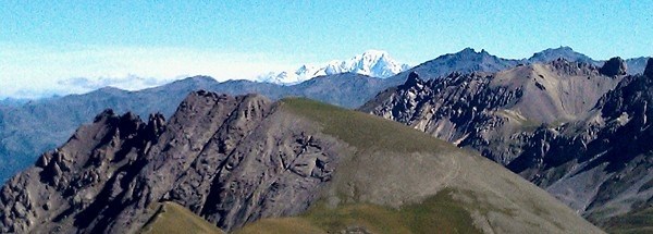
A bit higher than Col du Galibier (2645m) lies a viewpoint table at 32m high. From there, one can see the glaciers from la Barre des Écrins and from la Meije (massif of "les Écrins") to the south, as well as Mount Blanc, one of the Aiguilles d'Arves, the peek of Rochebrune (massif of Queyras) farther to the south-east, and finally the Great Galibier (3229 m).
To log your visit please answer to the following question,send to me as an email or just take a picture with GPSR,yourself from the wiewpoint's table it's ok
"There is great quantities of a grey rock at the feet of Alpine mountains. This rock was the lubrificating sole between European and African plates. What is the rock's name?"
GEOLOGICAL HISTORY OF HOW THE ALPS WERE FORMED
Nowadays geologists have a general knowledge of how planet Earth works inside with lithospheric tectonic plates. Therefore, due to some internal energy, linked in particular to the presence of radioactive elements that "heat" the core of the Earth; on the planet's surface are moving against each other great rigid sheets of lithosphere (crust + softer outermost part of the upper mantle) which are constituting the most peripheral part (100 to 150 km thick, to be compared with the 6370 km-thick radius of the planet). They are moving away, closing in or sliding according to internal currents of the softer part of the upper mantle, on which they "float" and that goes 670 kilometer deep (asthenosphere).
The history of the Alps stems from reconstituting the displacements of the European and African plates. The steps of this history have been determined by analyzing nowadays' rocks and landscapes. Indeed, by using methods and principles from their science, geologists have traced back the history of our Alps, in which all begins by the disappearance of an ocean.
The premise of the divergence movement. 250 million years ago (during Trias), a great continent - Pangea - was polished by erosion and was slowly sinking (subsidence). Sediments were laid down on the shallow sea which flooded Pangea.
Divergence and continent slimming. Around 200 million years ago (during the beginning of Jurassic), the continent was stroke with divergence movements and extension deformations, breaks or normal faults. It got cut in huge continental blocks while getting more thin at the same time, which caused a great depression that quickly got occupied by a deeper sea into which sediments were getting laid down.
Divergence and oceanisation. Around 155 million years (Upper Jurassique), the continental plate got ripped off, and the hot mantle started to partly melt down and created an ocean floor composed of darker and denser rocks (basalts and gabbros) than clear and less dense continental rocks (granites, gneiss). This ocean featured two shifted components: the central Atlantic and the Alpine ocean. Deep down, sediments cover the oceanic floors and their continental borders. Obviously, the world's geography was tremendously changed... bye bye Pangea, hello Europe, Africa, Americas! Africa drifted towards east from Europe.
Central Atlantic, then soon replaced by South and North Atlantic, is still "alive" nowadays and keeps on growing at an average speed of 2 centimeters per year. The alpine ocean then disappeared and was replaced... by the ALPS! WHAT HAPPENED? The convergence movement of plates! Between 155 and 100 million years (lower Cretaceous), the inversion of relative movements Europe - Africa caused the alpine ocean to sink (subduction) under Africa ! Why? Because of the opening of South Atlantic! This caused Africa to be pushed towards north (check out a world map).
How did it happen? Both continents Europe and Africa, which constituted the boundaries of the alpine ocean, were moving towards each other. The alpine ocean, featuring denser rocks (density 2.9), "sank" under Africa (density 2.7) and slowly disappeared between 100 and 65 million years (upper Cretaceous). In Queyras, rocks kept trace of this event!
Eventually Europa, pulled by the alpine ocean, starts getting under Africa... but for analog density reasons, the system gets stuck and the European continent breaks down into big scales which act upon each other under Africa, thus creating alpine reliefs!
At Col du Lautaret, the sight over Col du Galibier - from Côte Plaine to Grand Galibier - displays the overlapping of Oriental Alps on Occidental Alps. Nowadays, convergence of European and African plates is still going on, and Alps are becoming higher and higher despite erosion.