Kronplatz
Plan de Corones
FTF: swissroli
STF: Team Eurosailer
 - - - DEUTSCH
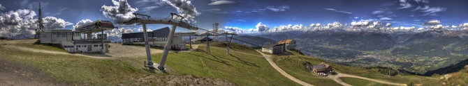
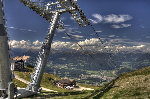
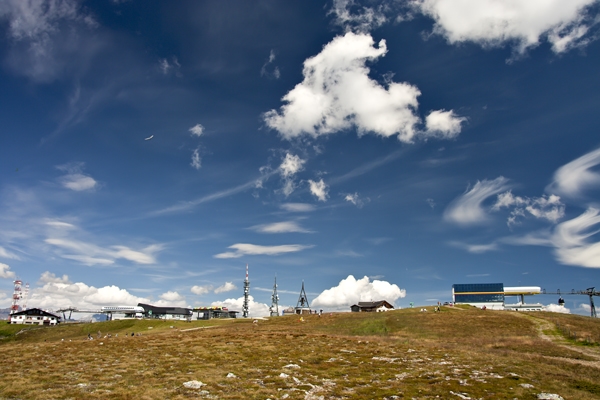
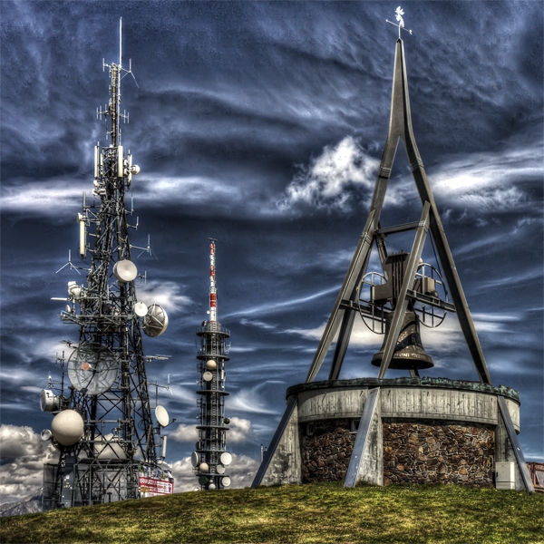
Der Kronplatz (Ladinisch: Plang de Curunes) ist ein 2275 Meter hoher Berg in Südtirol am Rande der Dolomiten. Er ist Hausberg von Bruneck (aber größtenteils zur Gemeinde Enneberg gehörig) und ein bekanntes Skigebiet mit modernen Aufstiegsanlagen. Der höchste Punkt ist das Spitzhörnle (genannt auch Hühnerspiel), bekannt auch durch seine Beschreibung durch Ludwig Steub. Hier versteckt liegt auch der Cache. Der Name des Berges stammt aus der Fanes-Sage: Am Kronplatz soll Dolasilla, die unverwundbare Prinzessin des Reiches der Fanes, gekrönt worden sein. Im Sommer bleiben einige Aufstiegsanlagen im Betrieb und der Berg ist deshalb ein beliebtes Gebiet für verschiedene Aktivitäten wie Wandern, Mountainbiking, Downhill-Mountainbiking und Paragleiten. Im Sommer, wenn kein Skibetrieb stattfindet, dienen die kargen Wiesen als Viehweiden. Die wenigen noch unberührten Teile des Berges weisen die für das Pustertal typische Bewaldung auf. Der Kronplatz ist ein Beispiel dafür, wie schönste Natur durch Menschenhand und dem Streben nach Profit entwertet wird; das ist wohl der Preis den wir für unseren Wohlstand zahlen müssen. Nichts desto trotz genießt man von hier eine herrliche Aussicht in alle Himmelsrichtung, und etwas abseits des Rummels, des Maschinelärms, des Stahls und des Betons könnte einem wieder klar werden, dass man sich auf einem Berg befindet, und es könnte sogar ein bisschen Bergstimmung aufkommen. Wer allerdings die Ruhe, den Zauber der Natur und die Abgeschiedenheit der Bergwelt sucht, ist am Kronplatz wohl fehl am Platz.
Der Kronplatz ist sozusagen von allen Richtungen erreichbar, entweder zu Fuß, mit dem Fahrrad, oder bequem mit diversen Aufstiegsanlagen von Reischach oder St. Vigil. Die Terrain-Bewertung bezieht sich auf den Startort Bergstation, da ich annehme, dass viele auf diesem Wege hier herauf finden werden. Wer einen Fußmarsch vorzieht kann z.B. bei den angegebenen Parkplätzen starten; von hier aus könnte man auch mit dem Mountainbike das Ziel erreichen.
Bitte den Cache wieder gut und ohne zu beschädigen verstecken!
************
 - - - ENGLISH
The Kronplatz (lad: Plang de Curunes) is a mountain (2275 meter) in South Tyrol, Italy. In the winter it is a ski resort and some of the lifts remain open in the summer for other activities such as walking, climbing, mountain biking, downhill mounting biking and paragliding. The highest point of this area is called "Spitzhörnle" or "Hühnerspiel", also known by Ludwig Steubs description; it's the place where the cache is hidden. The name of the mountain comes from the legend of Fanes: The invulnerable Dolasilla, princess of the kingdom of Fanes, was crowned at Kronplatz. In the summer when no skiing takes place, the barren meadows serve as pasturage. The few remaining unspoiled parts of the mountain show the typical forests of the Pustertal. Kronplatz is an example how beautiful nature is devalued by human hands and the pursuit of profit. Nevertheless you can enjoy a splendid 360 degree view from there, and a bit away from the summit station perhaps you can find a quieter spot. But who is looking for the tranquility, the beauty of nature and the solitude of the mountains, probably is out of place on the Kronplatz.
The Kronplatz is accessible quasi from all directions, either on foot, by bike, or comfortable with diverse ski lifts from Reischach or St. Vigil. The overall terrain rating refers to the starting point on the summit station. I think, most of the people will reach the summit using the ski lift. If someone wants to do some nice hike, you can start near the given parking coordinates. From here you can reach the cache also with the mountain bike.
Please re-hide the cache as well as possible without damaging!
************
 - - - ITALIANO
Il Plan de Corones (Plang de Curunes in ladino) è una montagna delle Alpi alta 2.275 metri. Si trova sul versante sud della Val Pusteria, in Alto Adige, 3 chilometri a sud di Brunico. L'origine del massiccio a forma di panettone, il cui punto più alto si chiama Spitzhörnle o anche Hühnerspiel, è vulcanica. Qui è nascosta la cache. Dal Sito panoramico offre un'ampia visuale sulle montagne circostanti, dalle Dolomiti fino alle vette delle Alpi in Val Venosta. Il termine "Plan de Corones" deriva dall’incoronazione leggendaria della principessa Dolasilla la quale fu incoronata con la Raietta, per opera del padre (il re di Fanes) al Plan, seconda la leggenda. Il nome ladino "Plang de Curunes", attestato nel 1780 come "Plang de corones", ne preserva ancora il significato originale, essendo i curunes, gli antichi spiriti dei monti della legenda ladina. IL termine "Kronplatz" ricalca il nome ladino, mentre le forme tedesche sono "Spitzhörnle", attestato nel 1557 come Spizhörnle e nel 1840 come Hörnle oder Kronplatz, nonché "Hühnerspiel", attestato nel 1474 come Hünerspyl e nel 1485 come Hünerspiel waldl. In estate, alcune funivie restano in funzione e, pertanto, la montagna è una meta apprezzata per le varie attività come l'escursionismo, il mountain biking, il downhill-mountain biking e il parapendio. In estate le praterie aride fungono da pascoli. Gli areali ancora intatti della montagna sono pochi e mostrano i boschi tipici della Val Pusteria. Plan de Corones è un esempio della svalutazione di natura eccezionalmente bella tramite la mano umana, e la sua ricerca del profitto; sarà il prezzo che dobbiamo pagare per la nostra prosperità. Tuttavia, da quassù si gode un magnifico panorama in tutte le direzioni. Forse un po’ lontano dalla stazione a monte puoi trovare anche un posticino un po’ tranquillo. Chi sta cercando la tranquillità, la bellezza della natura e la solitudine della montagna probabilmente sul Plan de Corones è fuori luogo.
Il Plan de Corones è raggiungibile più o meno da tutte le direzioni, o a piedi, o in bici, o comodo con la funivia da Riscone o San Vigilio di Marebbe. La valutazione del "Terrain" si riferisce al punto di partenza alla stazione a monte; penso che la maggior parte della gente userà la funivia per arrivare in cima. Se qualcuno vuole fare una bella passeggiata, può partire dalle coordinate date (parcheggio). Da qui si puo partire anche in mountain bike.
Prego riposizionare la cache bene nascosta senza danneggiarla!
************
Inhalt / content / contenuto:
FTF certificate
pencil, sharpener, logbook
schwarzes Steinchen
USB-Stick (32 MB)
leere DVD-R
Gummizug
Ohrringe
Golfball
Teelich
Münze
Hupe
Tausche gleichwertig/swap for equal value/scambia con lo stesso valore