 Not Your Ordinary Pothole
Little Falls, New York
Not Your Ordinary Pothole
Little Falls, New York
A couple of years ago when I was a young'un traveling with my Aunt Ede west out Route 5 to Utica and then northwest on Route 28 towards Watertown and eventually Campbell's Point on Lake Ontario to visit yet another aunt's camp, I used to marvel at the cliffs around Little Falls. The Thruway was just being built. Yes, I did say a couple of years ago. At that time, we still traveled on what were then the main highways.
Recently, my geologist daughter and I explored Moss Island near Little Falls. Once again, I became the fascinated 9 year-old whose wondering eyes perceived marvels. That visit prompted this first attempt at an earth cache focusing on the potholes at Moss Island.
Moss Island is located in Little Falls, New York, between the Mohawk River and the Erie/Barge Canal, at Lock 17. Here the river drops approximately 40 feet (12 m) in elevation draining to the east. Moss Island is not an actual island but is an outcrop of a very hard igneous intrusion separating the highest lock in New York State's Erie Canal system from the natural bed of the Mohawk River.
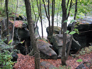
In eons long gone by, a huge waterfall, larger than Niagara Falls, cascaded over the rocky walls near the area that would eventually become Little Falls. The rocks at Little Falls are very ancient, some of the oldest in the world. The cliffs at Moss Island are known as the Burnt Rocks while the rocks at the bottom of the gorge and in the riverbed are called the bedrock. Both are made of the same plutonic rock that looks like granite except for the fact that it contains no quartz. Plutonic rocks are those cooled and solidified from molten materials extremely deep in the earth. Here, at Moss Island, they became uncovered through erosion.
How was this great gorge of ancient rocks formed?
After the glaciers receded a great lake, Lake Iroquois, was created by glacial melt waters. Water from Lake Iroquois poured over the rocks creating noteworthy evidences of water erosion at Little Falls. The tremendous power of the water from Lake Iroquois surging over the falls likely caused erosion of the rocks by water. It is thought by some that the water wore potholes of varying sizes in the rocky sides of the gorge. These potholes measure from a few feet to thirty feet wide. The potholes in the Little Falls Gorge are among the largest and most remarkable on earth. Some are fully thirty feet in depth and, others, even deeper. Nearly all are filled with debris. These holes are cut in the Adirondack syenite.
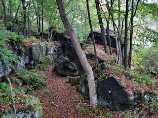
One formation theory holds that potholes like those at Moss Island were caused by vortices in former streams that rotated and vibrated “grinding stones”. Over long ages, the process gradually wore down a deep, cylindrical hole into the rock. It is not uncommon to find partial potholes at locales such as Moss Island or along the Niagara Escarpment where only a portion of a vertical cylindrical hole remains in the side of a gorge or cliff. Freezing and thawing could cause portions of the rock wall to fall away exposing a cylindrical cross section of a pothole such as those found here at Moss Island or at Eagle’s Nest on the Niagara Escarpment.
Most of these potholes are within a region of a half-mile below the lowest falls, the largest examples being on Moss Island where some of the potholes are large enough to walk around in. It is believed that the potholes were formed in the hard rock of the intrusion when today’s Mohawk River was the much larger Iromohawk River. That great river carried the melt water down the rocks and away from Lake Iroquois above the falls. It is suggested that the harder intrusion at Moss Island and the Little Falls gorge was slow to erode and forced the post-glacial Mohawk to narrow its channel and pick up speed in the location of Moss Island thus providing the force that would be necessary to drill the potholes. All of this amazing action is said to have occurred only about 15,000 years ago.
The potholes were put to interesting uses in Colonial and Revolutionary times. During Indian forays, Native American men frequently hid sheep and other loot in these holes and returned at night to remove them. The potholes were also hiding places for the settlers during the Revolution. The largest of the potholes of the Little Falls Gorge is the basin just below the lower falls, where the water is over 150 feet deep, at a point that is thought to be where the last stage of the great cataract exerted its force during the process of wearing down the Gorge channel. In the Little Falls Gorge, evidences of powerful water action and even potholes are noted over 300 feet above the bedrock of the river.
The glacial potholes on this small island are enormous, some reaching to impressive depths of 40-45 feet (12 -14 m)! Pictured at the left is a circular, hanging pothole ground into the Precambrian gneiss that makes up the island.

Potholes may also be referred to as weathering pits, tanks, tinajas, and water pockets depending on the geographic region in which they occur. Unlike the formations at Moss Island, it is said that potholes are usually not a part of an active drainage system; rather, they often form on flat or slightly dipping bedrock, typically sandstone surfaces, and huge potholes can form atop knolls, domes, and fins, and along the edges of mesas. Acting as rain gauges, they capture water directly from precipitation.

It is also thought that weathering and erosion of potholes results, at least in part, from biological activity. Quartz sandstone is ordinarily resistant to moisture-induced chemical changes but can be more rapidly altered through geomicrobiologic processes. Pothole location is commonly related to the presence of fractures or joints in the bedrock.
It seems that there is no carved in stone (pun intended) answer to the question of how potholes are formed. We’ll leave the debate to geologists far more knowledgeable than this lay woman.
This is probably why you DON’T want to explore the potholes in winter.

Sources:
geology.utah.gov/surveynotes/gladasked/gladpotholes.htm
http://www.sentex.net/~tcc/pothole.html
http://www.schenectadyhistory.org/resources/mvgw/history/001.html#lfgmap
While you don’t need to bring your kayaks or canoes, the most magnificent potholes at Moss Island are on the Little Falls side of the island and are best viewed from the water or at least from the shore on the other side of the Mohawk. Really, what is better than a nice, lazy paddle on the water?
To receive credit for Not Your Ordinary Pothole, please answer the following questions and email the responses to the cache owner. Please do not post your answers in your log. Logs containing answers to the questions will be deleted to maintain the integrity of the earth cache.
1. What theory is proposed to explain the formation of the massive potholes at Moss Island?
2. How does the rock composition of the potholes at Moss Island differ from potholes that might be found elsewhere?
3. The potholes on Moss Island are not only an awe inspiring sight but they were also used for practical purposes in pre-Revolutionary times? How were they used?
4. In addition to water erosion, what is another force that might cause the formation of a pothole?
5. Find a small pothole on Moss Island and measure its size using your GPSr or a body part as the measuring instrument. How many measuring units wide is this small pothole? Translate it into inches or centimeters. Please feel free to post a photo of your measuring process.
6. Stand in or position your kayak/canoe in a pothole and estimate the width and the height above water or land of the pothole in relation to YOUR size. Please feel free to post a picture of yourself in a pothole.
Please send your responses to the owner by private email BEFORE you log the cache. We hope you enjoy your trip to Moss Island as much as we did.
Moss Island has been declared a National Natural Landmark. It has not yet been named a State Park. Access to the island is available year round during the hours of 7 AM to dusk. It is possible that the parking lot near the lock will not be plowed in the winter. However, the island can still be accessed at the west end near the hydroelectric power plant. The trail to the potholes can be quite slick when wet and can be dangerous in the winter. DO NOT ATTEMPT TO GO TO THE POTHOLES IN THE WINTER. So, visit the island before the snow flies as, based on recent winters, you won’t be able to visit again until May. Sturdy footwear is recommended. This is probably not the best trail for small children especially on the river side of the island near the potholes. There are some pothole formations on the lock side and this area is fairly level for the young’uns.