Baía de Angra do Heroísmo (Terceira)
ATENÇÃO
A cache não está escondida nas coordenadas publicadas
Não coloquem fotos da cache!!!
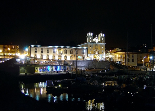
A Baía de Angra do Heroísmo localiza-se na cidade de Angra do Heroísmo, na costa Sul da ilha Terceira, nos Açores.
As suas águas têm uma profundidade média de 40 metros.
Reveste-se de importância histórica uma vez que, a partir do século XV, foi o porto de abrigo das naus da Carreira da Índia - carregadas de ouro, prata, porcelanas, especiarias e outras mercadorias -,
que aqui aguardavam a reunião das frotas para seguirem sob escolta da Armada das ilhas até ao Reino.
Aqui ficavam protegidas dos ventos dominantes de Norte e Nordeste, uma vez que os únicos ventos a que a baía é sensível são as tempestades de Sul e Sudoeste.
Estas encontram-se na origem de numerosos naufrágios, atestados na documentação e na tradição oral e confirmadas em numerosas evidências arqueológicas
que apenas recentemente começaram e ser identificadas mas onde desde já é possível identificar mais de 90 naufrágios históricos.
ATTENTION
The cache it's not hidden at the published coordinates
And do not post photos of the cache!!!
Angra do Heroísmo Bay or Baía de Angra do Heroísmo is a body of water near the city of Angra do Heroísmo on the island of Terceira in the Azores, Portugal.
Its waters have an average depth of forty metres.
The bay is of historical importance because, since the fifteenth century, it was the port where merchant ships returning from the East Indies and Brazil, full of gold, silver, porcelain, spices, rare woods, and other goods,
anchored and waited for an armed escort to accompany them the rest of the way to Portugal.
In the bay at Angra, ships were sheltered from the prevailing north and northwest winds; only storms generating winds from the opposite direction, the south or southeast, posed a threat.
Nonetheless, there were numerous shipwrecks when adverse winds drove the merchantmen against Terceira's lee shore.
There is a wealth of documentation in local archives as well as a lively oral tradition attesting to the fact that many ships foundered in these waters.

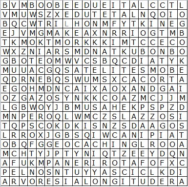
Caça Palavras
| trilho |
|
geocaching |
| altitude |
|
longitude |
| rio |
|
cito |
| latitude |
|
taipina |
| satelite |
|
distancia |
| logbook |
|
gps |
| troca |
|
arvores |
| caixa |
|
rota |
| contentor |
|
posicao |
| montanha |
|
mapa |
| A |
B |
C |
D |
E |
F |
G |
H |
I |
J |
K |
L |
M |
N |
O |
P |
Q |
R |
S |
T |
U |
V |
W |
X |
Y |
Z |
| 1 |
2 |
3 |
4 |
5 |
6 |
7 |
8 |
9 |
10 |
11 |
12 |
13 |
14 |
15 |
16 |
17 |
18 |
19 |
20 |
21 |
22 |
23 |
24 |
25 |
26 |
letras que se cruzam da parte de cima do puzzle
letters from the intersecting words in the top half of the puzzle
letras: __ __ __ __ __
Valores: __ + __ + __ + __ + __ =
x35/100 =
+16.823
N38__-___
letras que se cruzam da parte de baixo do puzzle
letters from the intersecting words in the bottom half
letras: __ __ __ __ __
Valores: __ + __ + __ + __ + __ =
x45/1000 =
+10.551
W27__-___
Ver resultado --->You can check your answers for this puzzle on Geochecker.com.
Divirtam-se
Have Fun