Like huge turquoises the atolls ot the Maldives shimmer in the deep blue of the Indian Ocean. Their development is one of the big wonders of our world, because these geological structures are built by living beings: Colonies of tiny coral animals, mainly stony corals, that live in symbiotic relationship with monocellular algae called zooxanthellae, take in - with their aid - calcium ions and carbon dioxide diluted in the sea water and excrete calcium carbonate in crystalline form (aragonite), thus, in the course of many generations, creating a constantly growing calcium construct – the reef.
How reefs develop
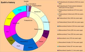
Early forms of reefs were built in cryptozoic eon by microorganisms (e.g. cyanobacteria) that caught particles of sediment. During the ordovician period, early anthozoa began building reef structures; at the permian-triassic-boundary these anthozoa became extinct; later, more modern forms of stony corals took over.
 copyright by heicel 2012
Then and now, the same requirements are necessary: consistent water temperatures – preferrably between 20° C and 29° C -, a salinity of about 2,7 percent and a stable underground that mustn’t be submerged too deeply because the zooxanthellae need light. If these requirements are met, colonies of corals start to grow and continue to grow year after year, towards the light at the surface as well as towards the nutrient-rich open sea. This way, an ever thicker and broader calcerous structure evolves: the reef.
The area of the Maldives offers all these requierments in abundance. The atolls and island of this state rest on the Lakkadavian-Chagos-Ridge, an ancient, formerly partly volcanic mountain range an the seam of India; it has sunk under water by the slow rise of the sea level of the Indian Ocean long ago. Here, corals found ideal conditions. Glaciation and glacial melts several times resulted in the sinking or rising of the sea level, so that many parts of the newly built reefs at some points of time came to be over water. Then wind and weather worked the surface of the grown structures and sometimes changed the aragonite into limestone. When the islands were covered by water again, corals resettled and started to build again. Today, some of the primeval reefs can even be found far away from any sea. The Northern Calcerous Alps, for example the Dolomites, consist mainly of fossile coral reefs. And the famous Sphinx above Gizeh was built from the stone of a coral reef 20.000 years old.
Reef types
Reefs mainly are classified as:
• fringing reefs – structures immediately adjacent to the coastline. This ist he most common form of reefs (e.g. Red Sea)
• barrier reefs – reef systems running parallel to the coastline, but separated from the shore by more or less wide, occasionally quite deep lagoons (Australia, Central America, Bahamas, New Caledonia etc.).
• atolls – reefs forming circles around a wide lagoon that surround one or sometimes several islands; this kind of reefs is found mainly in the Pacific Ocean (Polynesia, Micronesia etc.) and the Indian Ocean (Maldives).
Reef zones
Many of the Maldivian atolls are so-called ‚fried egg’-islands, where the typical zones of reefs are easy to see:
• An island – big or small, surrounded by a white beach of fine coral sands – forms the highest part of the atoll. It represents the oldest part of the reef; deep underneath its calcerous ‚armor’ one can find the original underground, where thousands of years ago corals settled colonially. Today, this part of the atoll rises about one meter above sea line.
• A relatively shallow, more or less wide strip of water surrounds the island: the lagoon. Its calcerous underground offers a protected area for the origination of so-called micro-atolls: tiny coral islands that show the same zones as their ‚big sisters’.
• The roof – the highest point of the coral reef itself – encompasses the lagoon; it reaches up to, sometimes even above sea level.
• The outer reef at the intertidal zone represents the border between the atoll and the open sea. Almost all of the Maldivian atolls have a relatively steep outer reef, because they foot on the sides of mountains instead of flat plains.
From:
wikipedia, diff. articles
M. Grant Gross: ‚Oceanography – a view of the earth’
Oliver Arndt: ‚Malediven – Geographie eines Inselstaats’
To log this earthcache:
• please tell us by mail, what special feature in the reef structure you can see – facing the ocean - directly to your left at the given coordinates.
• draw any of the coral forms that you can see near the given coordinates.
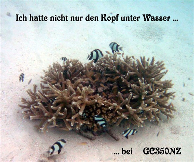
Though not a requirement for logging any more we would be delighted if you would load up a foto from your stay with your log – even if it shows neither you nor your GPS
Geologie im Werden: Korallenriffe
Wie riesige Türkise schimmern die zauberhaften Atolle der Malediven im tiefen Blau des Indischen Ozeans. Ihre Entstehung ist eines der großen Naturwunder unserer Welt – denn diese geologischen Strukturen werden von Lebewesen gebaut: Kolonien von winzigen Korallentierchen, insbesondere Steinkorallen, die in Symbiose mit einzelligen Algen leben, nehmen mit deren Hilfe Calciumionen und Hydrogencarbonat-Ionen aus dem Meerwasser auf, fällen daraus Calciumcarbonat-Kristalle (Aragonit) und erbauen so im Verlauf vieler Generationen ein ständig wachsendes, stabiles Kalkgebilde – das Riff.
Wie Riffe entstehen
Die ersten Riffe entstanden bereits im Präkambrium durch Mikroorganismen (z.B. Cyanobakterien), die Sedimentpartikel einfingen. Im Ordovizium begannen die ersten Blumentiere mit dem Riffbau, starben jedoch an der Perm-Trias-Grenze aus. Später folgten ihnen ‚modernere’ Formen der Steinkorallen als Baumeister.
copyright by heicel 2012
Damals wie heute gelten dieselben Voraussetzung für die Bildung von Riffen: gleich bleibende Wassertemperaturen – am besten zwischen 20° C und 29° C -, ein konstanter Salzgehalt des Wassers von rund 2,7 Prozent und ein stabiler Untergrund, der nicht zu tief unter der Wasseroberfläche liegen darf, da die Zooxanthellen Licht benötigen. Sind diese Voraussetzungen gegeben, bildet sich ein Bewuchs aus Korallen, der im Laufe der Jahre immer weiter wächst, sowohl dem Licht als auch der Nahrungszufuhr aus der offenen See entgegen, so dass sich nach und nach immer breitere und dickere Strukturen bilden: stabile Riffe.
Das Gebiet der Maldiven bietet all diese Voraussetzungen in reichem Maße. Die Atolle und Inseln dieses Staates ruhen auf dem Lakkadiven-Chagos-Rücken, einem rund 2700 Kilometer langen, teilweise vulkanischen Gebirge am Rand der indischen Landmasse, das durch das langsame Ansteigen des Meeresspiegels während vergangener Erdzeitalter unter Wasser absank. Hier fanden die Korallentierchen ideale Bedingungen vor. Vergletscherung und Gletscherschmelzen sorgten immer wieder für wechselnde Wasserstände, so dass viele Teile der neu entstandenen Riffe über Wasser gerieten. Dann bearbeiteten Wind und Wetter die gewachsenen Strukturen dieser Inseln und wandelten mancherorts Aragonit in Kalkstein um. Stieg der Wasserstand wieder, siedelten sich neue Korallen an und bauten weiter. Manche der urzeitlichen Riffe aus der Vorzeit liegen heute sogar weitab von jedem Meer. So bestehen etwa die Nördlichen Kalkalpen zu großen Teilen aus fossilen Korallenriffen, und die berühmte große Sphinx nahe Gizeh wurde aus dem Gestein eines 20.000 Jahre alten Korallenriffs erbaut.
Riffformen
Man unterscheidet drei Hauptarten von Riffen:
• Saumriffe – die sich unmittelbar an die Küste anschließen; diese Riffart ist die am weitesten verbreitete (z.B. Rotes Meer).
• Barriereriffe – Riffsysteme, die parallel zur Küste verlaufen, von dieser aber durch breite und zumindest gelegentlich auch tiefe Lagunen getrennt sind (Australien, Mittelamerika, Bahamas, Neukaledonien).
• Atolle – kreisförmige Riffe um eine breite Lagune, die eine oder auch mehrere Inseln umgibt; diese Art findet man meist im Pazifik (Polynesien, Micronesien etc.) und dem Indischen Ozean (Malediven).
Die Zonen eines Atolls
Viele der maledivischen Atolle sind so genannte Spiegelei-Inseln, an denen sich die typischen Riffzonen besonders gut erkennen lassen:
• Eine mehr oder minder große Insel, gesäumt von einem Strand aus feinem Korallensand, bildet die höchste Stelle des Atolls. Sie stellt den ältesten Teil des Riffs dar; unter ihrem ‚Panzer’ aus Kalkstein kann man den ursprünglichen Grund finden, auf und um dem sich die Korallen vor Jahrtausenden anzusiedeln begannen. Heute erhebt sie sich nur etwa einen Meter über den Meeresspiegel.
• Um die Insel herum erstreckt sich ein relativ flacher, mehr oder weniger breiter Wasserstreifen – die Lagune. Ihr Untergrund besteht aus Korallenkalk und bietet Raum für die Entstehung so genannter Mikro-Atolle: kleiner Koralleninseln, die dieselben Zonen aufweisen wie ihre ‚großen Schwestern’.
• Das Riffdach – der höchste Punkt des Riffs – umgibt die Lagune; es liegt knapp unterhalb des Meeresspiegels, kann aber gelegentlich auch darüber hinaus ragen.
• Das Außenriff – die Brandungskante des Riffs – bildet die Grenze zwischen Atoll und offener See. Bei den maledivischen Atollen fällt das Außenriff typischerweise relativ steil ab, da sie auf den Hängen eines Gebirges fußen und nicht auf flachem Boden. Nur sehr selten kann man hier auch ein Vorriff – die ‚neue Baustelle’ eines Riffs - sehen.
Quellen:
Wikipedia,
div. Artikel M. Grant Gross: ‚Oceanography – a view of the earth’
Oliver Arndt: ‚Malediven – Geographie eines Inselstaats’
Um diesen Earthcache zu loggen:
• schreibe uns bitte in einer Mail, welche spezielle Eigenheit du zu deiner Linken innerhalb der Riffstruktur an den angegebenen Koordinaten sehen kannst (Blickrichtung Ozean).
• zeichne eine der Korallenformen, die du nahe den angegebenen Koordinaten sehen kannst.
Wir würden uns besonders freuen, wenn du ein Foto von deinem Aufenthalt dort mit deinem Log hochladen würdest – auch wenn es weder dich noch dein GPS zeigt!
Für Bannerfreunde:
<a href="http://coord.info/GC577M7" target="_blank""><img src="https://s3.amazonaws.com/gs-geo-images/a36afcf9-a084-4c51-a0ee-3c96498d3cc3_l.jpg" width="329" height="275" </a>