This Earthcache is located just off the soldier pass trail. There
is a gate that is open to the site from 8:00 am - 6:00pm everyday.
You will need to pick up a Red Rock Pass. You can
pick them up all over the area. They cost $5 per day
PLEASE USE CAUTION AS THE EDGES CAN BE VERY UNSTABLE
AND COULD CAVE IN AT ANY TIME PLEASE SEE MAP BELOW
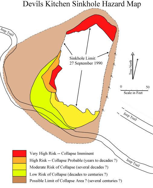
Devils Kitchen Sinkhole
HISTORIC PERSPECTIVE
A description of the Devils Kitchen collapse is presented by Albert
E. Thompson (Those Early Days, 1968, Sedona Westerners, p. 60). "My
parents were living in Sedona in the early 1880s and heard the
crash when the spot caved in. Mother said the dust from the cave-in
filled the air all day and the sun looked like it was shining
through heavy smoke. Her brother, Jim James, was the first one to
see the new hole in the ground". The current examination of the
sinkhole (as of September 27, 1990) suggests that the southernmost
wall of the collapse area may have pre-dated the supposed cave-in
of the entire area. The reason for saying this is that there is
surface evidence that rounded outcrops and a patina of manganese
[oxide] suggests that an opening in that area may have been small
but open for several hundred years. This weathering is in sharp
contrast to the recent collapse (latter half of 1989) of the entire
northern wall of the sinkhole. The edges of the new breaks are very
angular and the surface soil has not yet begun to slough off. A
massive collapse of the northern portion (one third?) of the
sinkhole added very large blocks to the sinkhole collapse rubble.
The largest of these blocks rotated outward toward the center of
the rubble pile and was detached along three bounding walls from
its caprock.
ABOUT SINKHOLES
There are several possible reasons for the development of sinkholes
but the most common is from the collapse of caves in limestone
bedrock by the agency of weakly acidic groundwater and the
dissolution of the mineral calcite. Small amounts of dissolved
carbon dioxide in rainwater provide weakly acidic groundwater which
slowly dissolves limestone along fractures. Over long periods of
geologic time these slow rates of dissolution are capable of making
gigantic underground caverns. During the formation of a cave the
slowly enlarging chambers are formed below the water table and may
form important groundwater aquifers. If a cave is finally unroofed
by erosion or the groundwater table lowers below the cave floor,
then, and only then, will the cave be termed "dry" and be able to
form secondary stalagmites and stalactites. The Karst region of
Yugoslavia lent its name to "karst topography" that is common in
many parts of the world where limestone is the dominant surface
rock type. In such a topography there are collapse areas of large
subterranean caves, internal drainage below ground level, and poor
soil development. Caves which form in such regions may become so
large that the overlying rocks collapse into the openings.
Sinkholes formed in this fashion may collapse with great speed. Or
they may slowly collapse upward until the opening is filled with
broken rubble.
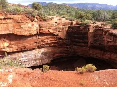
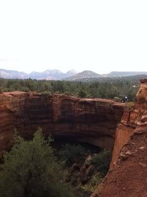
THE DEVILS KITCHEN SINKHOLE
Unlike typical karst topography the outcrops in the immediate
vicinity of the Devils Kitchen sinkhole contains no limestone. The
walls of the collapse area contain massive [Schnebly Hill]
sandstone in the upper walls and a much weaker [Hermit Formation]
shaly siltstone in the undercut lowest portions of the sinkhole
walls. This sinkhole, as well as the similar Devils Dining Room to
the south of Sedona is formed as the result of deep-seated collapse
of Redwall Limestone caves at depth.
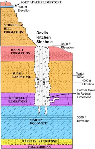
The schematic cross section shows that the top portion of the
Devils Kitchen sinkhole is at an approximate elevation of 4510 feet
above sea level. Rocks at this position belong to the upper part of
the Hermit formation which is made up of bedded sandstone,
siltstone, and shale. These strata were formerly classified as part
of the "Supai Sandstone" (i.e., the "Red Rocks") but recent
reclassification has restricted "Supai" to the massive sandstone
beginning at about 210 feet below the collar of the sinkhole. The
massive Supai Sandstone is approximately 430 feet thick and rests
conformably on top of Redwall limestone which is approximately 180
feet thick. Below the Redwall is a thick layer of [Devonian] Martin
Dolomite and [Cambrian] Tapeats Sandstone. The crystalline
Precambrian basement lies approxi¬mately 1350 feet below the collar
of the Devils Kitchen sinkhole. .
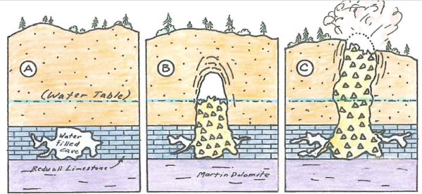
This shows how a sinkhole may develop. Part A shows a limestone
cave beneath a cover of sandstone, much the same as seen at the
Devils Kitchen area. Part B shows that as the cave got too large to
support the roof rocks it began to cave in the overlying strata.
The broken rock which occupies the enlarging cavity is called
breccia. Part C show how the upward-stoping collapse finally
breaches through the surface.
| I have earned GSA's highest level: |
 |