The Ancient Ohio River
The view before you was formed by the Ohio River - the Ohio River that existed before the last glaciers that came through Ohio. You see, before the many glaciers that covered Ohio to various degrees in the past there was another river system running through Ohio - the Teays river.
The Teays River
Below is an illustration of the Teays:
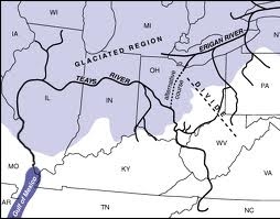
From the illustration it can be seen the Teays originated in modern day North Carolina, passed through West Virginia, and then North just south of Columbus Ohio, then west across Indiana and Illinois, before it turned south and feed into the ancient Gulf of Mexico (which reached up to where Cairo Illinois is today). and unlike most modern North American rivers it flowed north. This river existed before the ice ages that started occurring 3 million years ago - before humans were present in this region. The only remains of this river that are readily apparent are large river valleys with small streams running through them. Geologist deduced this ancient river by noting river erosion that runs through glacier till (the unsorted sediments left by glaciers) in exposed areas.
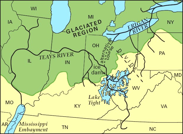
As parts of Ohio were covered by successive glaciers the river was diverted. The large ice sheets would form dams - forming lakes. The overflow of these lakes would cause floods and new rivers to form. Below shows Lake Tight (named for William G. Tight who discovered it) which formed about 2,000,000 years ago during the Kansan Glacial period. This lake filled areas of the current Ohio river valley near the Ohio/Kentucky/West Virginia intersection. At its greatest size it was 900 feet deep and covered an area 2/3 that of Lake Erie.
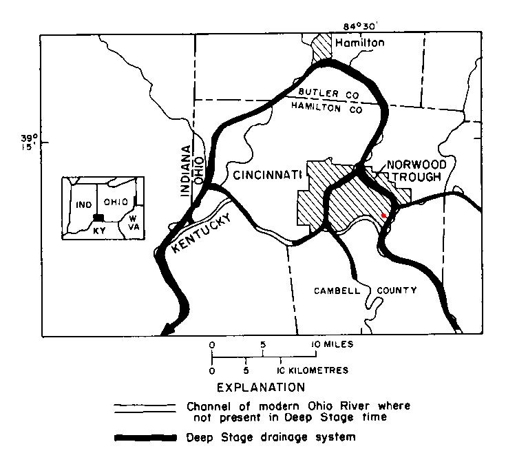
The Deep Stage Ohio River
Successive glaciers pushed Teays south until it formed what is called the "Deep Stage Ohio". It may be difficult to see, but the valley before you contains the Little Miami river. What you are viewing before you is evidence of the Deep Stage Ohio river. The Deep Stage Ohio was run along the valley to the east and south of where you are standing until 100,000 years ago and the arrival of the Wisconsin Glacier. The illustration below shows where this Deep Stage Ohio River ran. Where you are standing is the red dot.
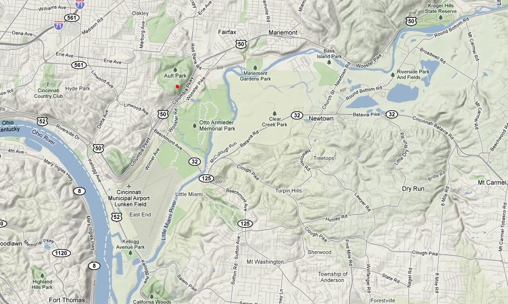
This glacier create a large lake upstream that overtopped a divide about 3 miles west of Cincinnati near Anderson Ferry. The ice advance over the lake to about the present position of the Ohio river, before retreating. Below is a terrain map of the current valley showing the ancient river basin. Again you are standing at the red dot.
To log this earthcache:
1) Estimate the width of the an cent river valley before you. Look in the direction of the Mt. Washington water tower which is south east of your location.
2) Based on the cache description an your observations - what evidence is there that the Deep Ohio passed through this valley?
3) What direction did the Deep Ohio River flow through the valley before you?
Optional: A photo of you or your gps with the magnificent view.
References:
http://en.wikipedia.org/wiki/Glacial_Lake_Tight
http://www.teachersdomain.org/resource/ket08.sci.ess.earthsys.ohioriver/
http://www.dnr.state.oh.us/parks/magazinehome/magazine/sprsum04/teaysriver/tabid/364/Default.aspx
http://www.dnr.state.oh.us/Portals/10/pdf/GeoFacts/geof10.pdf
http://www.cincinnati-oh.gov/transeng/downloads/transeng_pdf7076.pdf
http://en.wikipedia.org/wiki/Teays_River